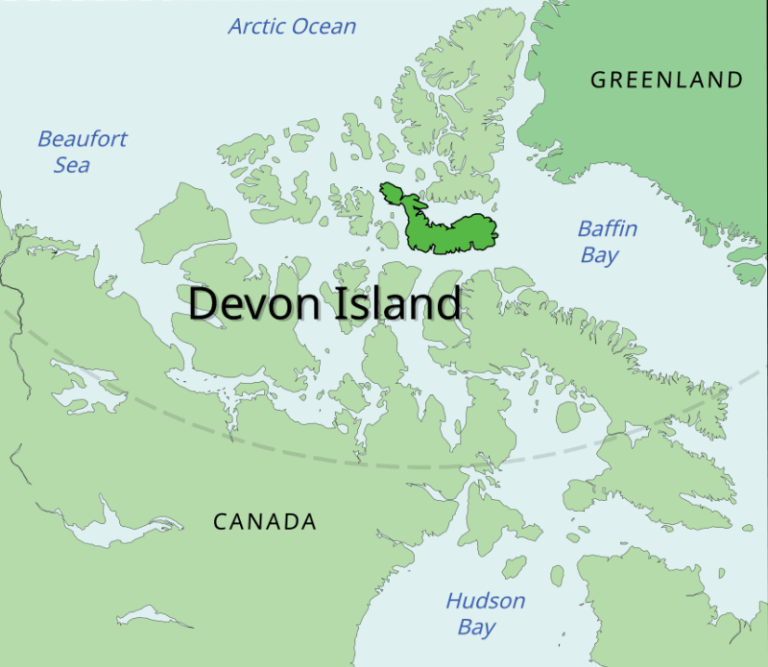
Devon Island
- 14 Mar 2026
In News:
Scientists from the National Aeronautics and Space Administration (NASA) continue to use Devon Island in the Canadian Arctic as a major Mars analogue research site. The island’s barren terrain, extreme cold, and polar desert conditions closely resemble the Martian environment, making it an ideal location to test next-generation rovers, autonomous drones, and life-support systems intended for future Mars missions.
Location and Geographic Setting
- Devon Island is located in the Canadian Arctic Archipelago within the territory of Nunavut, Canada, and lies well within the Arctic Circle.
- It is recognized as the largest uninhabited island on Earth, characterized by extremely harsh climatic conditions and limited biological activity.
Neighbouring Regions
- North: Separated from Ellesmere Island by Jones Sound
- South: Separated from Somerset Island and Baffin Island by Lancaster Sound
- West: Cornwallis Island, home to the settlement of Resolute
- East: Baffin Bay
Climate and Environmental Conditions
Devon Island is classified as a polar desert, characterized by extremely low precipitation and harsh climatic conditions.
Key climatic features include:
- Short growing season: Approximately 40–55 days per year
- Summer temperatures: Around 2°C to 8°C
- Winter temperatures: Can fall to −50°C
- Low solar energy input and minimal rainfall
These conditions severely limit vegetation growth, resulting in a barren, rocky landscape covered by snow and ice for much of the year.
Major Geographic Features
Haughton Impact Crater
- A prominent feature of the island is the **Haughton Impact Crater, approximately 20 kilometres (14 miles) wide, formed about 39 million years ago when a meteorite struck the region.
- The crater’s rocky, fragmented terrain and absence of vegetation make it one of the closest terrestrial analogues to the cratered surface of Mars.
Martian-Like Terrain
Devon Island contains several geological features that resemble Martian landscapes:
- Permafrost and underground ice deposits
- Dried lakebeds and sedimentary plains
- Deep canyons and rugged rocky valleys
These conditions simulate the extreme dryness, cold, and geological features found on Mars.
Endolithic Microbial Habitats
- Scientists have discovered microorganisms living inside rocks within the Haughton Crater. This phenomenon, known as endolithic colonisation, allows microbes to survive extreme conditions such as intense ultraviolet radiation and limited nutrients.
- Such findings help scientists understand how life might survive in harsh extraterrestrial environments.
Scientific and Space Exploration Significance
Testing Space Technology
Devon Island serves as a testing ground for space exploration equipment, including:
- Advanced planetary rovers
- Autonomous aerial drones
- Deep-drilling systems
- Pressurized exploration vehicles
Testing technologies in such remote conditions helps engineers evaluate equipment that cannot be repaired once deployed on Mars.
Searching for Signs of Life
- Research on microbial life in Devon Island’s frozen soils provides insights into potential biosignatures and survival strategies of life on Mars, guiding future astrobiology missions.
Astronaut Training
- The island’s extreme isolation, harsh climate, and barren terrain also provide a realistic environment for astronauts preparing for long-duration space missions, helping them adapt to the psychological and operational challenges of extraterrestrial exploration.
Udhampur-Srinagar-Baramulla Rail Link (USBRL)

- 06 Jun 2025
In News:
The Udhampur-Srinagar-Baramulla Rail Link (USBRL) is a transformative 272-km railway project aimed at connecting the Kashmir Valley to the Indian Railways network. With Prime Minister Narendra Modi inaugurating the Chenab Rail Bridge and flagging off Vande Bharat trains in June 2025, the project nears full operationalization.
Key Details:
Chenab Rail Bridge – World’s Highest Railway Arch Bridge
- Height: 359 metres above riverbed (taller than the Eiffel Tower).
- Length: 1,315 metres; Arch span: 467 metres.
- Status: Highest railway arch bridge in the world.
- Engineering feat in Reasi district, Jammu and Kashmir.
Strategic All-Weather Connectivity
- Reduces dependency on the Srinagar-Jammu highway, which is prone to closure due to snow and landslides.
- Ensures year-round transportation and supply lines.
Enhanced Military Mobility
- Enables rapid movement of troops and equipment to border regions.
- Crucial for national security due to the region's proximity to international borders.
- Designed to withstand blasts and harsh weather.
Anji Bridge – India’s First Cable-Stayed Rail Bridge
- Length: 473 metres; Height: 331 metres.
- Located on the Katra-Banihal section.
- Supported by 48 cables, suitable for rugged Himalayan terrain.
Vande Bharat Connectivity
- High-speed trains introduced on Katra–Srinagar route.
- Improves passenger comfort and reduces travel time.
Economic Boost via Trade
- Improves market access for Kashmiri products: apples, saffron, handicrafts, and dry fruits.
- Facilitates faster freight movement, integrating the region into national trade networks.
Tourism Promotion
- Easier access to religious and scenic sites.
- Expected to boost tourism post disruptions (e.g., Pahalgam incident).
- Cheaper and faster rail travel enhances domestic footfall.
Engineering Resilience
- Chenab Bridge:
- Blast-resistant (withstands up to 40 kg TNT).
- Wind resistant (up to 260 kmph).
- Seismic-resilient with a 120-year design life.
- Symbol of India’s capability in building infrastructure in high-risk zones.
Time Efficiency
- Travel time between Jammu and Srinagar will reduce from 6 hours (by road) to 3–3.5 hours (by rail).
- Facilitates emergency services, logistics, and routine travel.
National Integration and Inclusion
- 943 bridges, 36 tunnels covering 119 km — overcoming Himalayan terrain challenges.
- Integrates remote districts of Jammu & Kashmir into India's railway grid.
- Promotes inclusive development and better governance outreach.
Madden-Julian Oscillation (MJO)
- 29 May 2025
In News:
In 2025, the early onset of the southwest monsoon in Kerala (May 24) and Mumbai (May 26—the earliest on record) was significantly influenced by the Madden-Julian Oscillation (MJO), as reported by the India Meteorological Department (IMD).
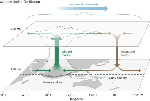
What is the MJO?
- The Madden-Julian Oscillation (MJO) is a large-scale atmospheric phenomenon observed in the tropical belt (30°N to 30°S).
- It is an eastward-moving disturbance involving winds, clouds, pressure, and rainfall that circles the globe every 30 to 60 days (occasionally up to 90 days).
- Identified in 1971 by Roland Madden and Paul Julian, it differs from ENSO (El Niño–Southern Oscillation) in being intra-seasonal and transient.
Phases of MJO:
- Enhanced Convective Phase:
- Associated with increased cloudiness, low pressure, and above-normal rainfall.
- Characterized by rising air and moisture convergence.
- Suppressed Convective Phase:
- Brings clearer skies and reduced rainfall due to subsiding dry air.
- These phases shift eastward and influence weather globally, including India.
Formation and Movement:
- Triggered by surface wind convergence that causes upward motion, cloud formation, and upper-level wind divergence.
- Travels at 4–8 m/s, completing a global circuit roughly every 30–60 days.
MJO’s Impact on Indian Monsoon:
- MJO in active phase over the Indian Ocean can:
- Trigger early monsoon onset, as seen in 2024 and 2025.
- Enhance cyclogenesis and monsoon depressions.
- Improve intra-seasonal rainfall variability.
- May 2025 Event:
- The MJO was in Phase 4 with amplitude >1, indicating strong activity conducive to rainfall.
- This condition, along with favorable local and oceanic factors, supported early monsoon advancement in India.
Global Influence of MJO:
- Cyclone Modulation: Alters frequency and intensity of tropical cyclones.
- Weather Extremes: Affects jet streams, triggering cold surges, heatwaves, or floods in mid-latitudes (e.g., U.S., Europe, Australia).
- Interaction with ENSO: While not always directly linked, MJO can amplify or be influenced by El Niño conditions.
Jinchuanloong niedu

- 28 May 2025
In News:
A newly discovered genus and species of sauropod dinosaur, Jinchuanloong niedu, has been identified from fossil remains found in the Xinhe Formation near Jinchang city in Gansu Province, northwestern China. This discovery adds to the growing diversity of early-diverging sauropods from the Middle Jurassic period, dating back approximately 165 million years.
About Jinchuanloong niedu
- Jinchuanloong niedu belongs to the group Eusauropoda, which comprises early-diverging, strictly herbivorous, long-necked, quadrupedal dinosaurs.
- The fossil specimen includes a nearly complete skull with mandible, five cervical vertebrae, and 29 articulated caudal vertebrae.
- The skull measures approximately 31 cm in length and 12.5 cm in height. Notably, complete skulls are rare in non-neosauropod eusauropods due to their fragile nature.
- The skull is well-preserved, although slightly deformed due to compression. Most cranial sutures remain distinctly visible, aiding paleontological study.
Paleontological Significance
- This species is the earliest sauropod identified from Gansu Province, enriching the diversity of known early-diverging sauropods in East Asia.
- The discovery contributes valuable insights into sauropod evolution in northwest China, particularly during the Middle Jurassic.
- The presence of Jinchuanloong niedu helps trace lineage continuity in the aftermath of a global warming event during the late Early Jurassic, which led to the extinction of other sauropod groups, leaving only eusauropods.
Eusauropoda and Sauropod Evolution
- Sauropods, which existed from the Early Jurassic to the Late Cretaceous, were the largest land animals to have ever lived and were found on all continents.
- Characterized by massive size, long necks and tails, and a herbivorous diet, sauropods include both neosauropods and non-neosauropods.
- During the Middle and Late Jurassic, non-neosauropod eusauropods like Shunosaurus, Omeisaurus, and Mamenchisaurus-like taxa became dominant.
Massive Solar Eruption: The ‘Bird-Wing’ Event

- 27 May 2025
In News:
In May 2025, astronomers observed a dramatic solar eruption, dubbed the “Bird-Wing” event, due to its unique wing-like plasma structure. Originating from the Sun’s northern hemisphere, the eruption stretched over 1 million kilometers—more than twice the Earth-Moon distance.
Key Components of the Event
- Solar Flare:
- A sudden, intense burst of electromagnetic radiation caused by magnetic field realignment on the Sun.
- Classified from A to X (increasing order of X-ray brightness).
- Travels at light speed, reaching Earth in about 8 minutes.
- Can disrupt radio communication and GPS systems by affecting the ionosphere.
- Coronal Mass Ejection (CME):
- A massive release of charged solar plasma and magnetic fields into space.
- Travels at 250–3000 km/s, reaching Earth in 18 hours to 3 days.
- Can cause geomagnetic storms, impacting power grids, satellites, navigation, and inducing auroras.
The “Bird-Wing” event involved both phenomena, but Earth narrowly avoided a direct hit, experiencing only a glancing blow. The impact was minimal and did not cause significant technological disruptions.
Associated Geomagnetic Effects
- A filament eruption, distinct from solar flares, was responsible for the minor geomagnetic activity observed. These are cooler plasma structures held by magnetic fields and appear as dark strands on solar imagery. When destabilized, they erupt and emit charged particles.
- Northern Lights (Aurora Borealis) were expected to be visible over parts of the UK, particularly Scotland, as the trailing edge of the CME brushed past Earth.
Space Weather Risks from Solar Storms
According to the European Space Agency (ESA) and NASA:
- Solar flares can disrupt radio signals and satellite communication.
- Solar particles, including high-energy protons, may arrive hours later, posing risks to astronauts and electronics.
- Geomagnetic storms can:
- Disturb Earth's magnetic field.
- Affect power lines, pipelines, and satellites.
- Expand the upper atmosphere, increasing drag on low-orbit satellites, potentially altering their trajectory.
- Temporarily reduce the number of cosmic rays reaching Earth by deflecting them.
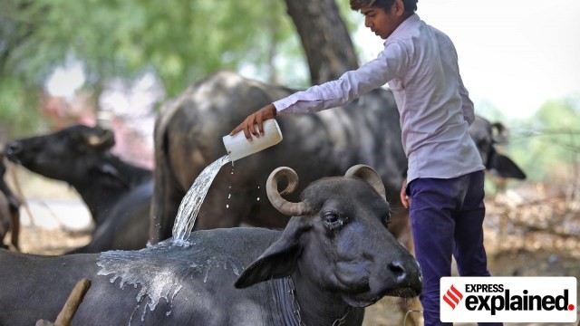
PashuAushadhi Initiative
- 12 Mar 2025
In News:
The Government of India has launched the PashuAushadhi initiative to establish dedicated stores across the country offering affordable, high-quality generic veterinary medicines. This move aims to reduce the out-of-pocket expenditure of farmers and enhance animal health and productivity, especially in the livestock and dairy sectors.
Key Features:
- Modelled on PMBJK: Inspired by the success of the Pradhan Mantri BharatiyaJanaushadhiKendras (PMBJK) that provide generic human medicines, the PashuAushadhiKendras will serve the same purpose for animals.
- Affordable Veterinary Drugs: These Kendras will provide non-branded (generic) veterinary medicines at significantly lower prices.
- Ethnoveterinary Medicines: Alongside allopathic drugs, they will also stock traditional remedies based on indigenous knowledge, compiled by the National Dairy Development Board (NDDB). These include formulations for fever, diarrhoea, indigestion, mastitis, and more.
Implementation Framework
- The initiative is part of the revised Livestock Health and Disease Control Programme (LHDCP), approved by the Union Cabinet.
- Run by Co-operative Societies & PM-KisanSamriddhiKendras (PMKSKs).
- An initial budget of ?75 crore has been allocated under the LHDCP for veterinary medicine access and sales incentives.
Livestock Health and Disease Control Programme (LHDCP)
- With an outlay of ?3,880 crore for 2024–25 and 2025–26, the LHDCP focuses on:
- Prophylactic vaccination against major animal diseases (e.g., FMD, Brucellosis, CSF, PPR, Lumpy Skin Disease).
- Disease surveillance and veterinary infrastructure strengthening.
- Capacity building of veterinary services across India.
Need and Significance
- As per the 20th Livestock Census (2019), India has 535.78 million livestock, including over 302 million bovines.
- Livestock productivity is often hampered by preventable diseases.
- Farmers bear significant expenses on veterinary care, highlighting the need for cost-effective treatment options.
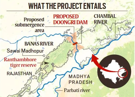
PKC-ERCP: Rajasthan’s River-Linking Project
- 25 Jan 2025
In News:
The Parbati-Kalisindh-Chambal-Eastern Rajasthan Canal Project (PKC-ERCP), part of the National Interlinking of Rivers (ILR) programme, aims to address water scarcity in 23 districts of Rajasthan, potentially benefiting 3.45 crore people. However, it has raised serious concerns over its ecological impact, particularly on the Ranthambore Tiger Reserve.
About the PKC-ERCP Project:
Aspect Details
Objective To channel surplus water from the Chambal basin for irrigation, drinking, and industrial use in Rajasthan and Madhya Pradesh
Estimated Cost ?72,000 crore (90% funded by the Central Government)
Water Allocation 4,100 MCM to Rajasthan and 3,000 MCM to Madhya Pradesh
Rivers Involved Chambal, Parbati, Kalisindh, Banas, and tributaries
Major Structure 39 m high, 1.6 km long dam across the Banas River, a Chambal tributary, near Doongri village, ~30 km from Sawai Madhopur
Submergence and Environmental Concerns:
- Total Submergence: ~408.86 sq km in Rajasthan.
- Reservoir Impact: 227 sq km to be submerged under the proposed dam across Banas River.
- Impact on Tiger Reserve:
- 37.03 sq km of the Ranthambore Tiger Reserve (total area: 1,133 sq km) to be submerged.
- This includes parts of Ranthambore National Park (392 sq km) and Keladevi Wildlife Sanctuary (674 sq km).
- May fragment the reserve, disrupting wildlife corridors and tiger movement.
- Ranthambore’s Significance:
- Home to ~57 tigers, it is one of India’s most prominent conservation areas.
- Situated at the Aravalli-Vindhya junction, with rich biodiversity, including leopards, hyenas, sloth bears, and iconic flora like Dhok trees.
- Encompasses the UNESCO-listed Ranthambore Fort and the Great Boundary Fault.
Arguments For the Project:
- Addresses chronic water scarcity in eastern Rajasthan.
- Promotes agricultural productivity, drinking water security, and industrial development.
- Aims to optimize water use by diverting surplus flows.
Arguments Against the Project:
- Biodiversity loss due to habitat submergence and reserve fragmentation.
- Risks to tiger conservation efforts.
- Potential violation of environmental safeguards under the Wildlife Protection Act and Forest Conservation norms.
Long-term ecological costs may outweigh short-term developmental gains.
Mount Ibu Eruption
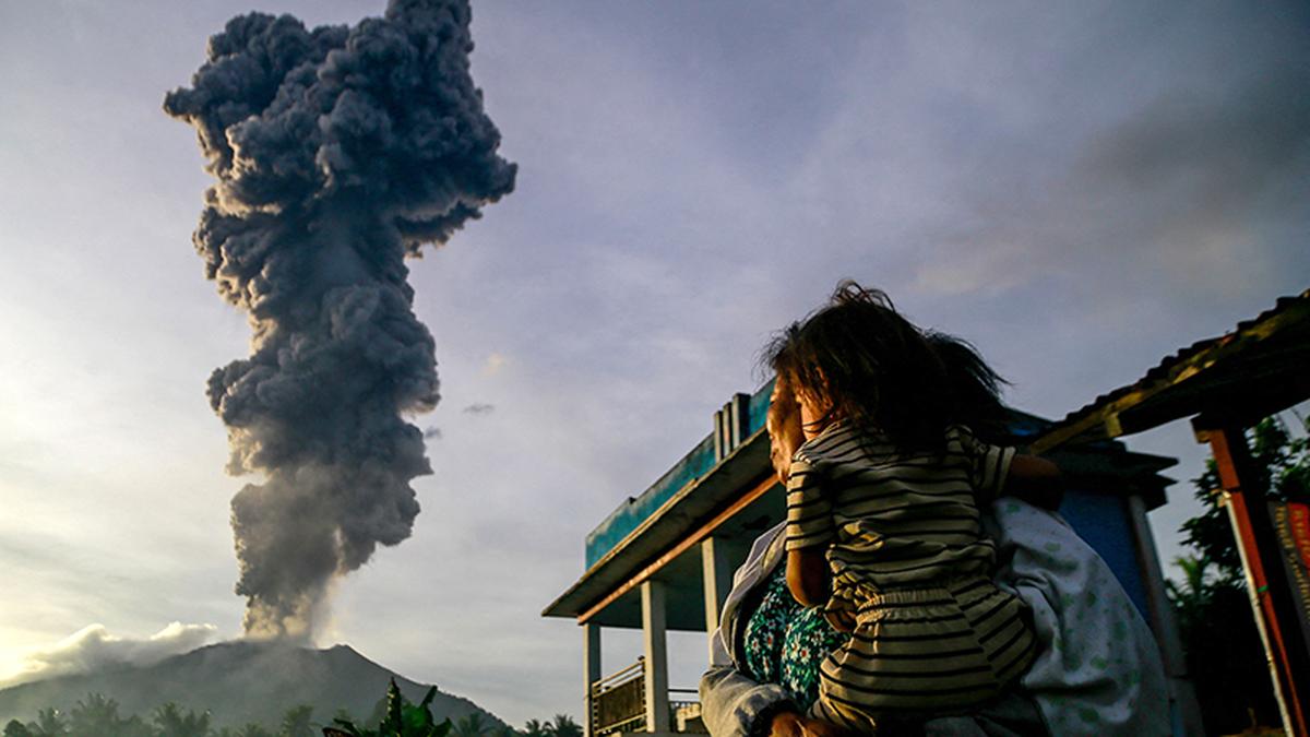
- 21 Jan 2025
In News:
Indonesia’s Mount Ibu erupted 1,000 times this month.
Overview:
- Location: Mount Ibu, Halmahera Island, North Maluku province, Indonesia.
- Volcano Type: Stratovolcano (composite volcano) – steep-sided, conical structure formed by successive layers of lava, ash, and pyroclastic material.
- Tectonic Setting: Located on the Pacific Ring of Fire, a major area of subduction zones with high volcanic and seismic activity.
Volcanic Context – Indonesia:
- Pacific Ring of Fire: Indonesia's location makes it one of the most volcanically active regions globally.
- Other Recent Eruptions:
- Mount Lewotobi Laki-Laki (twin-peaked volcano)
- Mount Ruang
- Both have shown heightened activity, triggering mass evacuations.
Indian Coffee Sector

- 21 Jan 2025
In News:
India is now the seventh-largest coffee producer globally with exports reaching $1.29 billion in FY 2023-24, almost double the $719.42 million in 2020-21.
Historical Background
- Origin: Coffee was introduced to India in the 17th century by Baba Budan, a Sufi saint, who brought seven Mocha beans from Yemen and planted them in Baba Budan Giri hills, Karnataka.
- This act laid the foundation for India’s coffee cultivation, which has since evolved into a robust agro-industry.
India’s Global Coffee Status
- 7th largest coffee producer globally (FY 2023–24).
- Exports: Reached $1.29 billion in FY 2023–24, nearly double the $719.42 million in FY 2020–21.
- Major export destinations: Italy, Belgium, Russia.
- Export Share: Over 70% of India's coffee is exported, mostly in unroasted (green bean) form.
Types of Coffee Cultivated
- Arabica: Mild flavor, higher market value.
- Robusta: Strong flavor, more robust; often used in instant coffee.
- India's production: Around 75% is a mix of Arabica and Robusta.
Geographical Distribution
- Major Coffee-Growing Regions:
- Karnataka: Leads with over 70% of national production (~248,020 MT in 2022–23).
- Kerala and Tamil Nadu follow.
- Other contributors: Andhra Pradesh, Odisha, and parts of Northeast India
- Agro-climatic Conditions:
- Altitude: 600–1600 meters
- Temperature: 15°C–28°C
- Rainfall: 150–250 cm annually
- Soil: Well-drained, loamy, rich in humus and minerals
Economic & Environmental Significance
- Coffee is largely grown in the Western and Eastern Ghats, biodiversity-rich zones with shade-grown plantations.
- These plantations:
- Conserve ecology and biodiversity
- Support sustainable agriculture
- Contribute to rural livelihoods
Domestic Trends
- Rising café culture, urbanization, and higher disposable incomes have led to increased coffee consumption.
- Domestic consumption rose from 84,000 tonnes (2012) to 91,000 tonnes (2023).
- Preference for coffee over tea is growing, especially in urban and semi-urban India.
Government Initiatives
- Coffee Board of India initiatives under the Integrated Coffee Development Project (ICDP) aim to:
- Enhance yields
- Expand to non-traditional areas
- Promote sustainable practices
- Araku Valley Model:
- Involves 150,000 tribal families
- 20% increase in production
- Backed by Girijan Co-operative Corporation (GCC) and Integrated Tribal Development Agency (ITDA)
- Aligned with Aatmanirbhar Bharat and rural empowerment
Current Challenges and Future Outlook
- Challenges: Climate change impacts, pest attacks, price volatility in global markets.
- Opportunities:
- Rising global demand for value-added products (roasted & instant coffee)
- Export incentives and improved logistics
- Potential for agri-tourism and organic branding
Dark Oxygen
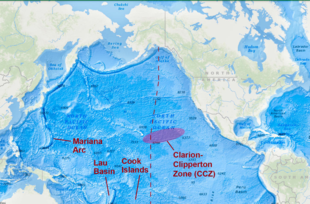
- 20 Jan 2025
In News:
Scientists who recently discovered that metal lumps on the dark seabed make oxygen, have announced plans to study the deepest parts of Earth's oceans in order to understand the strange phenomenon.
What is Dark Oxygen?
Dark Oxygen refers to oxygen produced deep under the ocean without sunlight or photosynthesis.
Discovered in July 2024, this challenges the long-standing belief that photosynthesis is the sole natural source of oxygen.
Where was it discovered?
- Location: Clarion-Clipperton Zone (CCZ), 13,100 feet deep in the North Pacific Ocean, between Hawaii and Mexico.
- Zone Significance: Rich in polymetallic nodules containing manganese, iron, cobalt, nickel, copper, and lithium — crucial for green technologies.
Mechanism of Oxygen Production
- Polymetallic nodules on the seafloor generate oxygen via electrochemical reactions.
- These nodules split seawater (H?O) molecules into hydrogen and oxygen, without any light.
- This process is non-biological and independent of photosynthesis.
Why is this Discovery Important?
- Scientific Paradigm Shift: Challenges the idea that photosynthesis is the only natural pathway for oxygen generation.
- Origins of Life: Suggests that oxygen production may have existed before photosynthetic organisms, reshaping theories of early Earth’s evolution.
- Astrobiological Implications: Indicates the possibility of oxygen-rich environments on other planets, even without sunlight — enhancing the search for extraterrestrial life.
- Environmental Tech Potential: Could lead to innovations in renewable energy and carbon-neutral technologies, using metal-based catalysis.
About the Clarion-Clipperton Zone (CCZ)
- Geographic span: Between Hawaii and Mexico in the North Pacific Ocean.
- Resources: Contains vast reserves of critical minerals like manganese, nickel, cobalt — essential for electric vehicles and solar technology.
- A focus area for deep-sea mining and sustainability studies.
India’s Recalculated Coastline
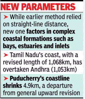
- 09 Jan 2025
In News:
India’s coastline has grown significantly over the past five decades, now extending 11,098 km in 2023-24, compared to 7,516 km in 1970. This marks an increase of 47.6% in just over five decades, attributed to a more precise methodology for measuring coastlines.
Key Factors Behind the Growth:
New Methodology for Measuring Coastlines:
- The old methodology used straight-line distances to measure the coastline, a method that didn't capture the complexity of India’s coastlines.
- The updated approach incorporates bays, estuaries, inlets, and other geomorphological features, offering a more accurate and detailed representation of the coastline.
- Advanced technologies like geospatial mapping have been used to ensure greater precision.
State-wise Recalculated Coastline Changes:
- Gujarat:
- Old coastline (1970): 1,214 km
- New coastline (2023-24): 2,340 km
- Growth: The largest absolute increase in coastline, nearly doubling its size.
- West Bengal:
- Old coastline: 157 km
- New coastline: 721 km
- Growth: A dramatic 357% increase, marking the highest percentage rise.
- Tamil Nadu:
- Old coastline: 906 km
- New coastline: 1,068 km
- Growth: Revised length now exceeds Andhra Pradesh’s coastline, which was 1,053 km.
- Puducherry:
- Old coastline: No major shift, but the updated data shows a contraction of 4.9 km (-10.4%), due to erosion and recalculations.
- Kerala:
- Old coastline: Relatively small increase of 30 km (5%), the smallest among the states.
Notable Observations:
- Andhra Pradesh is developing new ports like Ramayapatnam, Krishnapatnam, and Kakinada Gateway, aiming to boost economic growth and employment by leveraging its expanding coastline.
- The recalculated coastline helps in better maritime planning, focusing on port development, tourism, biodiversity conservation, and coastal erosion.
Impact of Coastline Expansion:
- Economic Growth:
- Coastal states, particularly Gujarat and West Bengal, benefit from an expanded coastline that improves maritime trade, port infrastructure, and tourism.
- The expansion supports industrialization, with growing logistics and transportation activities along the coast.
- Environmental Considerations:
- The new data aids biodiversity conservation, helping to track coastal erosion and accretion (land buildup), especially in areas like the West Coast.
- Understanding these changes is essential for disaster preparedness and sustainable coastal management.
- Coastlines of Emergence and Submergence:
- Emerging Coastlines: Land rising due to uplift or falling sea levels, such as along the Tamil Nadu Coast.
- Submerged Coastlines: Land that has sunk or been submerged due to rising sea levels, particularly noticeable along parts of Kerala’s coast.
Geographical Significance of the Expanded Coastline:
- India’s coast touches three major bodies of water: the Bay of Bengal (east), the Indian Ocean (south), and the Arabian Sea (west).
- The expansion reflects more than just geography—accurate coastline data is crucial for policy planning, maritime security, and resource management.
Homo juluensis
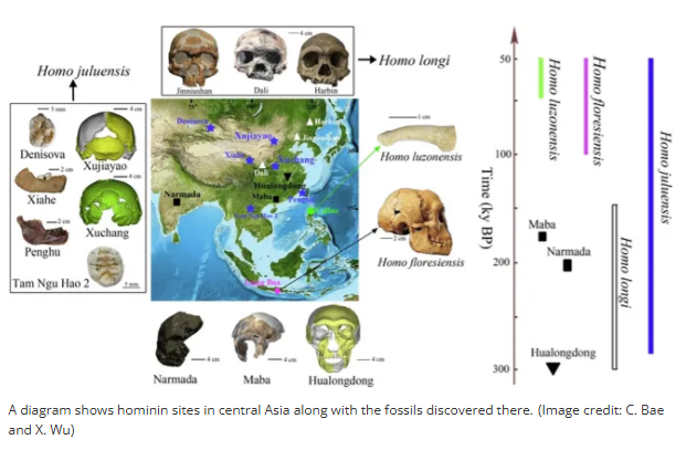
- 08 Jan 2025
In News:
A significant discovery in paleoanthropology has unveiled a new species of ancient humans, Homo juluensis. This species, characterized by its unusually large skulls, lived in eastern Asia between 300,000 to 50,000 years ago. The discovery adds to our understanding of human evolution, particularly during the Middle to Late Pleistocene epoch.
Key Characteristics
- Name Origin: Homo juluensis is named after "julu," meaning "big head," reflecting the species' large cranium.
- Geographical Range: This species inhabited regions of eastern Asia, including parts of China, Korea, Japan, and Southeast Asia.
- Fossil Evidence: Fossils have been discovered in Xujiayao and Xuchang (northern and central China), dating from 220,000 to 100,000 years ago.
- Physical Traits:
- Homo juluensis had large braincases, up to 30% larger than modern humans.
- They had thick skulls and facial features reminiscent of both Neanderthals and Denisovans.
- Their dental and jaw features show strong similarities to Neanderthals.
- Cultural Practices:
- They lived in small groups and were hunter-gatherers, hunting wild horses and potentially processing animal hides.
- Their tool-making and survival strategies indicate a complex level of social organization and resource use.
Relationship with Other Ancient Human Species
- Coexistence with Other Species: Homo juluensis coexisted with Neanderthals and Denisovans, potentially interacting and interbreeding with these species.
- Genetic Exchange: Studies suggest hybridization between Neanderthals, Denisovans, and early Homo sapiens played a significant role in shaping the genetic makeup of modern humans, especially in Asia.
- Evolutionary Significance: The species' relationship with other Pleistocene hominins is complex, involving shared ancestry with Homo sapiens, Neanderthals, and Denisovans. The genetic exchange among these populations likely influenced the course of human evolution in eastern Asia.
Neanderthals and Denisovans
- Neanderthals (Homo neanderthalensis):
- Lived between 400,000 to 40,000 years ago, primarily in Europe and parts of Asia.
- Neanderthals contributed significantly to the modern human gene pool, especially among non-African populations.
- Evidence of Neanderthal DNA is present in living humans, indicating past interbreeding with early human species.
- Denisovans:
- Identified through DNA analysis in 2010, based on fossils found in a Siberian cave.
- Closely related to Neanderthals, Denisovans inhabited diverse environments ranging from Siberian mountains to Southeast Asia’s jungles.
- Like Neanderthals, Denisovans interbred with both Homo sapiens and Neanderthals, influencing the genetic structure of modern populations, especially in Asia.
Implications for Human Evolution
- Complex Evolutionary Web:
- The discovery of Homo juluensis highlights the complex web of interrelated ancient human species during the Pleistocene epoch. These species did not live in isolation but likely interacted, competed, and interbred, shaping the evolutionary history of humans in Asia.
- Broader Understanding of Human Development:
- By expanding our knowledge of species like Homo juluensis, we gain a better understanding of the genetic diversity and cultural complexity in ancient human populations. This also provides insights into the environmental and social conditions that shaped early human survival strategies.
- Impact on Modern Genetics:
- The interbreeding between these ancient species has left a lasting imprint on the genetic makeup of modern humans, especially in regions like Asia, where Denisovan genes are still present in the DNA of some populations.
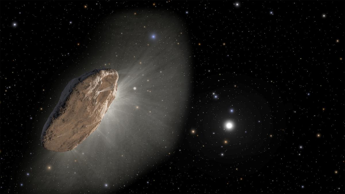
Dark Comets
- 20 Dec 2024
In News:
Dark comets are a newly identified class of celestial objects that challenge our traditional understanding of comets and asteroids. Unlike regular comets, these objects exhibit characteristics that blur the lines between comets and asteroids, leading astronomers to closely study their nature, origin, and significance.
Discovery and Background
The first hint of dark comets appeared in 2016, when asteroid 2003 RM exhibited strange orbital deviations that suggested it might be a comet in disguise. NASA further fueled this interest in 2017 when it discovered ‘Oumuamua, an interstellar object that entered our Solar System. Though initially classified as an asteroid, its erratic motion and lack of a visible tail led scientists to consider it a dark comet. Since then, several more objects with similar characteristics have been discovered, and astronomers now identify these objects as a new class—dark comets.
Characteristics of Dark Comets
- Appearance: Dark comets do not exhibit the brilliant, glowing tails typically associated with comets. Instead, they resemble asteroids, appearing as faint points of light in space. Unlike bright comets, they do not have a visible coma (a cloud of gas and dust) or a tail, making them much harder to detect.
- Size: Dark comets are typically small, ranging from a few meters to a few hundred meters in diameter. Due to their small size, there is less surface area for material to escape, preventing the formation of the iconic tails seen in traditional comets.
- Orbital Path: These objects follow elongated, elliptical orbits. While some of them travel close to the Sun, they can also venture to the outer reaches of the Solar System, far beyond Pluto, and even into the Oort Cloud—the distant region where long-period comets are believed to originate.
- Spin and Gas Dispersion: Dark comets often rotate rapidly, dispersing gas and dust in all directions. This rapid spin contributes to their invisibility, as the gas and dust are scattered evenly, making it more difficult for astronomers to detect their presence.
- Composition: The composition of dark comets may also play a role in their lack of visibility. Over time, the materials that form the bright tails of comets may be depleted, especially for older objects. As a result, dark comets may not release enough gas to produce a visible coma or tail.
Types of Dark Comets
There are two main categories of dark comets:
- Inner Dark Comets: These are smaller objects that reside closer to the Sun and typically travel in nearly circular orbits. They are often just a few meters in size, with less surface area for gas and dust to escape.
- Outer Dark Comets: These larger objects, measuring over 100 meters in diameter, travel in highly eccentric orbits, similar to Jupiter-family comets. These dark comets follow elliptical paths that bring them close to the Sun and then send them back toward the outer reaches of the Solar System.
Importance of Studying Dark Comets
Dark comets may hold critical clues about the early Solar System and the formation of Earth. Studying these objects can provide insights into the origins of water on Earth, as well as the ingredients necessary for life. Their unique composition and orbits also offer potential for understanding the processes that led to the formation of planets.
Recent Discoveries and Advancements
Astronomers recently discovered 10 new dark comets with the help of the Dark Energy Camera (DECam) on a large telescope in Chile. The DECam, designed to study distant galaxies and stars, has enabled researchers to detect these faint objects by analyzing images of the night sky. Further progress is expected with the upcoming Vera C. Rubin Observatory, which will feature the largest digital camera ever built. This new instrument will allow astronomers to capture more detailed images of the night sky and detect fainter objects, potentially doubling or even tripling the number of known dark comets in the next decade.
Key Facts:
- Dark comets lack the characteristic glowing tails of typical comets, instead resembling asteroids.
- They exhibit erratic motions and follow elliptical orbits, often extending beyond Pluto and into the Oort Cloud.
- They are typically small (a few meters to hundreds of meters wide) and spin rapidly.
- The first dark comet was identified in 2016, with more discoveries made in the years since.
- The Dark Energy Camera (DECam) in Chile has been instrumental in detecting these elusive objects, with a new Vera C. Rubin Observatory expected to further enhance detection in the future.
- Studies suggest that between 0.5% and 60% of Near-Earth Objects (NEOs) could be dark comets, many originating from the asteroid belt between Mars and Jupiter.
Ladakh's Aurorae
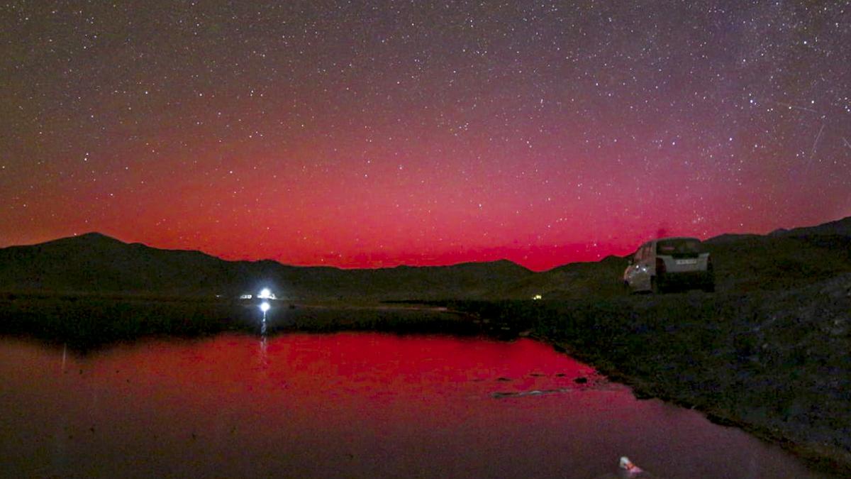
- 14 Oct 2024
In News:
In October 2024, Ladakh witnessed spectacular auroras, typically seen in higher latitudes, indicating increased solar activity. This phenomenon was reported following intense solar storms, with red and green lights observed in the night sky. The auroras were captured by all-sky cameras operated by the Indian Institute of Astrophysics (IIA) in Hanle and Merak.
What Are Auroras?
Auroras are vibrant displays of light caused by interactions between charged particles from the Sun and Earth's magnetosphere. When solar winds—streams of charged particles—collide with atoms in the upper atmosphere, they create visible light, similar to how neon lights function.
Causes of Recent Auroras
The recent auroras in Ladakh were linked to several strong solar storms, particularly coronal mass ejections (CMEs), which are significant bursts of solar wind and magnetic fields rising above the solar corona. The storms, emanating from active solar regions, traveled towards Earth at remarkable speeds, disrupting the normal space weather and allowing auroras to be visible at lower latitudes, including Mexico and Germany.
Implications of Solar Activity
Astrophysicists at the Center of Excellence in Space Sciences India (CESSI) noted that these auroras validate ongoing efforts in space weather monitoring. The increased solar activity is part of the solar cycle, which peaks approximately every 11 years. Current predictions indicate that Solar Cycle 25 may reach its peak in 2024.
Monitoring Space Weather
Organizations like the National Oceanic and Atmospheric Administration (NOAA) closely monitor space weather to provide timely warnings about solar events that could disrupt satellite communications and other services. The CESSI team successfully predicted the occurrence of solar storms, enhancing confidence in their ability to forecast space weather and its potential impacts.
Potential Hazards
While auroras are visually striking, intense solar storms can have detrimental effects, including:
- Satellite Disruption: Increased drag and radiation can damage satellites in low Earth orbit, affecting navigation, communications, and military operations.
- Communication Blackouts: Severe storms can interfere with radio and satellite communications, impacting daily life and services.
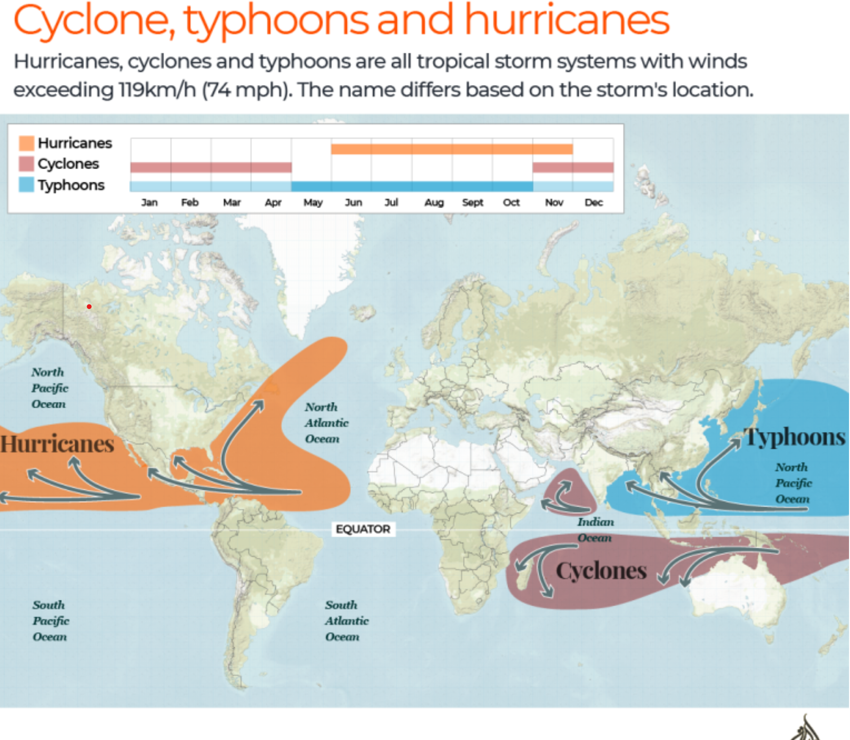
Increasing Frequency of Typhoons in Southeast Asia
- 07 Oct 2024
In News:
Overview of Typhoons
- Definition: A typhoon is a type of cyclone with wind speeds of 119 km/h or more, forming over warm ocean waters near the equator.
- Mechanism: As warm, moist air rises from the ocean, it creates a low-pressure system, leading to the characteristic circular wind patterns: anticlockwise in the Northern Hemisphere and clockwise in the Southern Hemisphere.
Recent Typhoon Events
- Typhoon Yagi: The most powerful tropical cyclone in Asia in 2024, with peak winds of 260 km/h. It caused significant destruction across Myanmar, Vietnam, Laos, and Thailand, displacing around 631,000 people and resulting in over 500 fatalities.
- Typhoon Bebinca: Reached wind speeds of 151 km/h, classified as a Category 1 storm, impacting eastern China with heavy rainfall and forcing evacuations for over 414,000 residents.
- Typhoon Shanshan: Affected Japan, bringing severe weather conditions.
Why are Typhoons more frequent?
- Rising Sea Surface Temperatures:
- Global warming has raised ocean temperatures, providing more energy for typhoon formation and intensification.
- Atmospheric Circulation Changes:
- Alterations in patterns, such as the weakening of the Walker Circulation, affect the frequency and paths of typhoons.
- El Niño and La Niña Effects:
- The El Niño-Southern Oscillation significantly influences typhoon activity. El Niño years often lead to increased typhoon occurrences in Southeast Asia, while La Niña can enhance cyclone activity in the Western Pacific.
- Increased Atmospheric Moisture:
- Higher global temperatures result in more evaporation, adding moisture to the atmosphere, which fuels stronger storms and increases rainfall intensity.
- Geographical Vulnerability:
- Southeast Asia’s location near warm ocean currents makes it a hotspot for typhoon activity, particularly along its extensive coastlines.
- Marine Heat Waves:
- Climate change has led to more frequent marine heat waves, causing extreme ocean warming, which contributes to intensified storms.
- Weaker Land-Sea Temperature Gradients:
- Changes in temperature differences between land and sea can prolong storm duration and severity.
- Urbanization and Environmental Degradation:
- Rapid urban development and the destruction of coastal ecosystems, like mangroves, diminish natural barriers against storm impacts.
Humanitarian Impact and Response
- The increasing intensity and frequency of typhoons have precipitated severe humanitarian crises in affected regions. The need for international cooperation in disaster response has become critical, involving collaboration among governments, civil societies, and humanitarian organizations to provide aid and support for those affected.
- Understanding the multifaceted reasons behind the rising frequency of typhoons is crucial for developing effective strategies to mitigate their impacts and enhance community resilience in Southeast Asia.
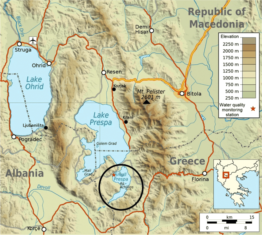
Little Prespa Lake's Decline
- 03 Oct 2024
In News:
Little Prespa Lake on Albanian-Greek border slowly dying.
Overview of Little Prespa Lake's Decline
- Location and Geography:
- Little Prespa Lake is situated on the Albanian-Greek border, primarily in Greece with a southern tip extending into Albania.
- It covers approximately 450 hectares in Albania, now largely transformed into swamps or dry land.
- Ecological Changes:
- Once a crystal-clear lake, it has degraded into a marshy area, with about 430 hectares in Albania suffering from significant drying.
- Local wildlife has shifted; cows now roam where fish once thrived.
- Historical Context:
- The lake's decline began in the 1970s when Albanian authorities diverted the Devoll River to irrigate surrounding agricultural lands, severely limiting water inflow.
- Climate Change Impact:
- Rising temperatures, mild winters, and decreased precipitation have intensified the lake’s ecological crisis.
- Local experts warn that continued dry winters and hot summers could lead to irreversible damage.
La Nina and North India’s pollution
- 01 Oct 2024
In News:
Recent research by scientists at the National Institute of Advanced Science (NIAS) has underlined the links between climate change, La Niña and air quality.
Key Points on Air Quality Outlook for Delhi and North India
- Delayed La Niña & Monsoon Retreat:
- Erosion of optimism for improved air quality this winter in Delhi.
- Significant pollution challenges anticipated in early winter months.
- Possible relief in December and January, contingent on La Niña strengthening.
- Impact of Stubble Burning:
- If stubble burning occurs at half the intensity of previous years, November air quality may deteriorate.
- Research Insights:
- Study by National Institute of Advanced Science (NIAS) links climate change, La Niña, and air quality.
- Notable air quality improvement in winter 2022-23 was linked to La Niña conditions.
- Late onset of La Niña contributes to air quality uncertainty.
- Changing Pollution Dynamics:
- Shift from local emission-centric views to broader climatological factors is necessary.
- Air quality in Delhi worsens during winter due to high humidity, calm winds, and poor pollutant dispersion.
- La Niña Delays:
- Delayed La Niña onset means weak winds and stagnant conditions, worsening pollution.
- Expected development between September and November 2024.
- Effects of Stubble Burning:
- North-north-westerly winds could carry pollution from stubble burning in Punjab and Haryana into Delhi.
- Potential Outcomes of Late La Niña Onset:
- If La Niña develops in December or January, may improve air quality slightly.
- However, a longer, severe winter could exacerbate pollution issues due to lower inversion layers.
- NIAS-SAFAR Model Predictions:
- Early La Niña could have worsened air quality in the peninsular region.
- Early onset might have improved northern air quality.
- Link to Climate Change:
- Evidence suggests extreme air pollution correlates with climate change.
- Emphasizes the need for rigorous mitigation efforts and broader airshed management.
- Call for Rethinking Air Quality Strategies:
- Focus on integrating larger climatic factors into air quality policies.
- Prioritize health-centric measures through collaborative efforts with scientific bodies.
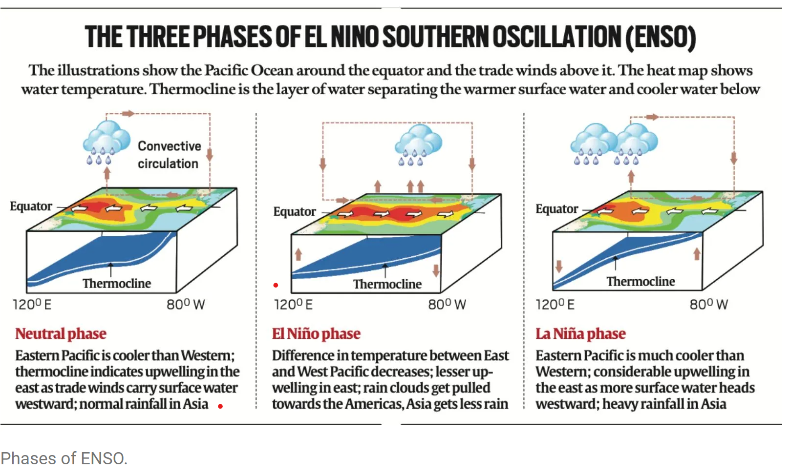
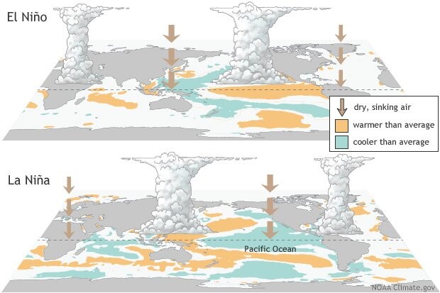
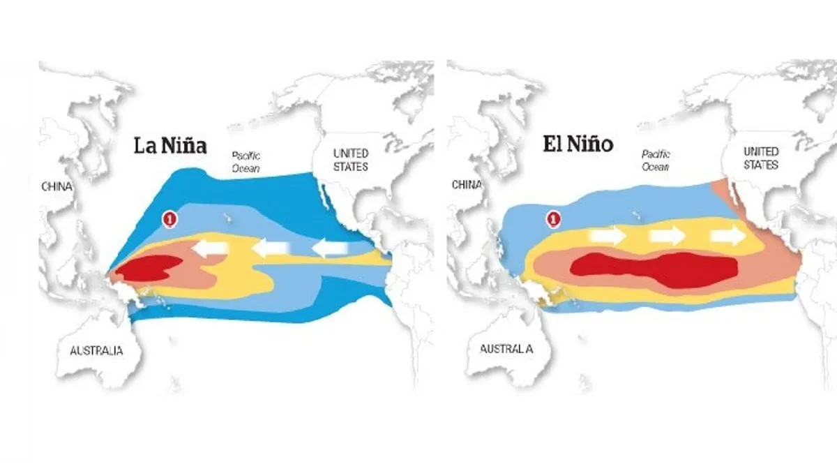
What is La Niña?
- La Niña (or ‘The Little Girl’ in Spanish) is a phase of what climatologists refer to as the El Niño Southern Oscillation (ENSO), a phenomenon that is a key driver of global natural climate variability.
- ENSO is characterised by changes in sea temperatures along the tropical Pacific Ocean due to atmospheric fluctuations overhead. These changes alter and interfere with the global atmospheric circulation, and influence weather worldwide.
- Occurring in irregular cycles of anywhere between two to seven years, ENSO has three phases — warm (El Niño or ‘The Little Boy’ in Spanish), cool (La Niña), and neutral.
- During the neutral phase, the eastern Pacific (off the northwestern coast of South America) is cooler than the western Pacific (around Philippines and Indonesia). This is because prevailing trade winds — caused by Earth’s rotation, between 30 degrees north and south of the equator — move east to west, sweeping warmer surface water along with them. The relatively cool waters from below rise to the surface to replace the displaced water.
- These wind systems weaken in the El Niño phase, leading to lesser displacement of warmer waters off the American coasts. Consequently, the eastern Pacific becomes warmer than usual. The opposite happens in the La Niña phase i.e. trade winds become stronger than usual and push larger quantities of water to the western Pacific.
All-India Reservoir Status
- 17 Sep 2024
In News:
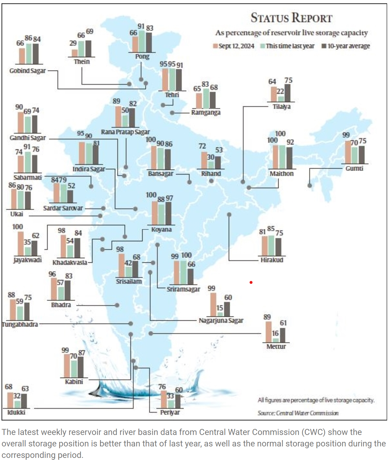
The southwest monsoon has provided significant rainfall across India, with total precipitation at 836.7 mm as of September 12, marking an 8% surplus for this time of year. The Central Water Commission (CWC) reports that reservoir levels are notably higher compared to last year and the 10-year average.
All-India Reservoir Status
- Total Capacity: 180.852 billion cubic metres (BCM) across 155 reservoirs.
- Current Storage: 153.757 BCM, which is 85% of total capacity.
- Last Year Comparison: 119.451 BCM (66%) and 10-year average of 130.594 BCM.
Regional Reservoir Highlights:
- North: 11 reservoirs at 68% capacity (13.468 BCM). Storage is lower than last year (81%) and decadal average (82%). Himachal Pradesh and Punjab saw significant rainfall deficits.
- East: 25 reservoirs at 76% capacity (15.797 BCM), improved from last year's 58%. Despite deficits in Nagaland and Bihar, overall rainfall has supported reservoir levels.
- West: 50 reservoirs at 90% capacity (33.526 BCM), a marked increase from 75% last year. Heavy rainfall, particularly in Gujarat, has led to flooding but boosted water reserves.
- Central: 26 reservoirs at 89% capacity (42.808 BCM), better than last year's 76%. This region has enjoyed normal or above-average rainfall.
- South: 43 reservoirs at 88% capacity (48.158 BCM), significantly higher than 49% last year. Regions traditionally receiving less monsoon rain have also seen improvements.
Comparison to 2023
- Improved Storage: Notable increases in states like Jharkhand, Odisha, West Bengal, and several others.
- Stable: No change in Goa and Telangana.
- Declines: Himachal Pradesh, Punjab, and Uttarakhand show worse conditions compared to last year.
River Basin Status
Major river basins exhibit normal or above storage levels, including:
- Barak (98.72%)
- Krishna (94.53%)
- Cauvery (93.54%)
- Narmada (92.19%)
- Godavari (91.85%)
- Others range from 83% to 66%.
Overall, the 2024 monsoon has led to improved water storage conditions across much of India, benefiting numerous states while highlighting specific areas of concern.
Centre gives clearance for ‘Mission Mausam’

- 13 Sep 2024
The Union Cabinet approved 'Mission Mausam,' a groundbreaking initiative with an investment of ?2,000 crore over the next two years. The mission, spearheaded by the Ministry of Earth Sciences (MoES), aims to significantly advance India's capabilities in atmospheric sciences and climate resilience.
Objectives and Key Focus Areas
Mission Mausam is designed to improve the accuracy and effectiveness of weather forecasting and climate management through several critical components:
- Advanced Technology Deployment: The mission will focus on deploying next-generation radars and satellite systems equipped with advanced sensors. These technologies are crucial for enhancing weather surveillance and prediction accuracy.
- Research and Development: A key objective of Mission Mausam is to bolster research and development in atmospheric sciences. This will include the development of enhanced Earth system models and advanced weather forecasting techniques.
- GIS-Based Decision Support System: An automated decision support system based on Geographic Information Systems (GIS) will be developed to facilitate real-time data sharing and improve decision-making processes.
Institutional Framework and Implementation
The Ministry of Earth Sciences will oversee the implementation of Mission Mausam. The following institutions will play central roles in the mission:
- India Meteorological Department (IMD)
- Indian Institute of Tropical Meteorology
- National Centre for Medium-Range Weather Forecasting
Additional support will come from other MoES bodies:
- Indian National Centre for Ocean Information Services
- National Centre for Polar and Ocean Research
- National Institute of Ocean Technology
Sectoral Benefits
Mission Mausam is expected to bring significant improvements across various sectors:
- Agriculture: Enhanced agromet forecasts will aid farmers in optimizing crop management and increasing resilience to climatic variability.
- Disaster Management: Improved monitoring and early warning systems will enhance disaster preparedness and response, potentially reducing loss of life and property damage.
- Defence: Accurate weather forecasting will support strategic planning and operational efficiency within the defence sector.
- Energy and Water Resources: Better weather predictions will lead to more efficient management of energy and water resources.
- Aviation: Safer aviation will be supported by more reliable weather information, reducing risks and improving travel safety.
- Tourism: Sustainable tourism will benefit from accurate weather forecasting, contributing to safer and more enjoyable travel experiences.
Mission Mausam represents a significant investment in India’s ability to manage and mitigate the impacts of climate change and extreme weather events, ultimately aiming to enhance the resilience of communities and support sustainable development.
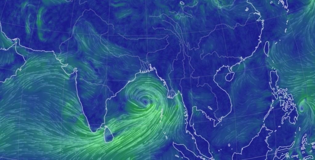
Uncommon Cyclones in the Arabian Sea
- 09 Sep 2024
Cyclones are intense weather systems with low atmospheric pressure and rotating winds, forming over warm tropical waters. These storms cause severe weather, including heavy rainfall, strong winds, and storm surges. Cyclones are categorized based on wind speeds, from tropical depressions to severe cyclonic storms. Warm ocean surfaces and high humidity fuel these storms, with atmospheric conditions like wind shear and moisture influencing their strength and formation.
The North Indian Ocean plays a key role in global weather systems, particularly the summer monsoon. Warm waters from the Arabian Sea and Bay of Bengal are crucial for moisture generation during monsoon seasons. However, despite the warm ocean surfaces that typically promote cyclones, this region has fewer cyclones compared to other tropical oceans. A mix of factors—both promoting and suppressing cyclone formation—makes the North Indian Ocean a unique and less cyclone-prone area.
The Indian Ocean stands out due to its monsoonal circulation, marked by seasonal wind reversals north of the equator. It also has "oceanic tunnels" connecting it to the Pacific and Southern Oceans, which influence its weather. The Pacific tunnel introduces warm water into the upper layers, while the Southern Ocean brings cooler waters into deeper levels. These oceanographic features contribute to distinct weather patterns, including influencing the formation and behavior of cyclones.
As the pre-monsoon season begins and the Sun moves into the northern hemisphere, the Arabian Sea rapidly warms. The Bay of Bengal, typically warmer, heats further, driving atmospheric convection and rainfall. These warming patterns make the Bay of Bengal more prone to cyclones, while the Arabian Sea, with its cooler waters and stronger wind shear, experiences less cyclone activity. These conditions contribute to significant differences in cyclone formation between the two seas.
Impact of Climate Change on Cyclones in the Indian Ocean
Climate change is amplifying the Indian Ocean’s warming, bringing in more heat from the Pacific Ocean while the Southern Ocean pushes warmer waters into deeper layers. These changes, combined with shifts in winds and atmospheric humidity, are causing the Indian Ocean to warm at a rapid pace. This warming is affecting cyclone formation, increasing the frequency and intensity of storms. The Indian Ocean acts as a "clearinghouse" for ocean warming, impacting global weather patterns and intensifying cyclone activity.
Monsoon and Cyclone Seasons in the North Indian Ocean
- The monsoon heavily influences cyclone activity in the region. During the monsoon, strong winds cool the Arabian Sea, reducing the likelihood of cyclone formation. In contrast, the Bay of Bengal sees more low-pressure systems, although many do not become cyclones due to wind shear that weakens their energy.
- The North Indian Ocean experiences two distinct cyclone seasons—pre-monsoon and post-monsoon—unlike other regions that typically have just one. Cooler temperatures and stronger wind shear keep cyclone numbers low in the Arabian Sea, compared to the Bay of Bengal.
- Cyclone Asna, formed in August 2023, was a rare cyclone for this time of year. It developed from a land-based depression that moved over the Arabian Sea, marking the first August cyclone in the region since 1981. This rare occurrence highlights how rapidly warming oceans, influenced by climate change and El Niño, can drive unexpected cyclone formations.
Typhoon Yagi
- 10 Sep 2024
In News:
A devastating series of events unfolded in Vietnam, as a bridge collapsed and a bus was swept away by severe flooding, raising the death toll to at least 65. The fatalities are attributed to Typhoon Yagi and the subsequent heavy rains, which have wreaked havoc across the Southeast Asian country.
In Depth:
- The typhoon made landfall in Vietnam’s northern coastal provinces of Quang Ninh and Haiphong with wind speeds of up to 149 kilometers per hour (92 miles per hour) on Saturday afternoon.
- It raged for roughly 15 hours before gradually weakening into a tropical depression early Sunday morning.
- Vietnam’s meteorological department predicted heavy rain in northern and central provinces and warned of floods in low-lying areas, flash floods in streams and landslides on steep slopes.
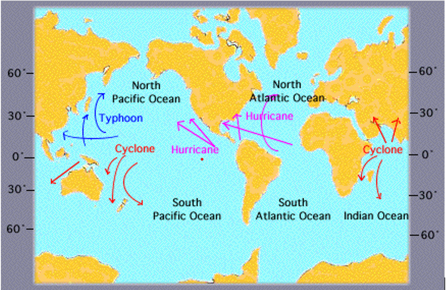
What is a cyclone?
- The term 'Cyclone' is derived from the Greek word 'Cyclos' which means 'Coiling of the Snake'.
- Cyclones are created by atmospheric disturbances around a low-pressure area and are usually accompanied by violent storms and severe weather conditions. Basically, a tropical cyclone is a deep low-pressure area.
Tropical Cyclone Remal
- 24 May 2024
Why is it in the News?
The first cyclone in the Bay of Bengal this pre-monsoon season, Cyclone Remal, is expected to make landfall between Sagar Island in West Bengal and Bangladesh's Khepupara on Sunday midnight.
About Cyclone Remal:
- The IMD has forecasted that a depression in the Bay of Bengal is likely to concentrate into a severe cyclonic storm and make landfall between Sagar Island in West Bengal and Khepupara in Bangladesh around May 26 midnight.
Name of the cyclone:
- If the cyclone is formed, it will be named 'Remal', which means 'sand' in Arabic.
- The cyclone has been named ‘Remal’, according to a system of naming cyclones in the Indian Ocean region.
- A standard naming convention is followed for tropical cyclones forming in the North Indian Ocean, including the Arabian Sea and the Bay of Bengal.
- As the IMD is a part of the Regional Specialised Meteorological Centres (RSMCs), it gives names to the tropical cyclones after consulting 12 other countries in the region.
- The name 'Remal' has been suggested by Oman which means 'sand' in Arabic.
What is a Tropical Cyclone?
- A tropical cyclone is a rapidly rotating storm system characterized by a low-pressure centre, strong winds, and a spiral arrangement of thunderstorms that produce heavy rain.
- These cyclones develop over warm tropical or subtropical waters and can cause significant damage due to high winds, heavy rainfall, and storm surges.
How a Tropical Cyclone is Formed?
- Tropical cyclones form over warm ocean waters near the equator.
- The process begins when warm, moist air rises from the ocean surface, creating an area of low pressure.
- This causes surrounding air with higher pressure to move toward the low-pressure area, warming up and rising as well.
- As this air rises and cools, the moisture condenses to form clouds.
- The system of clouds and wind starts to spin and grow, fueled by the ocean's heat.
- When the wind speeds increase sufficiently, an eye forms in the centre of the cyclone.
Characteristics of a Tropical Cyclone:
- Calm Center: The eye of the cyclone is calm and clear, with very low air pressure.
- High Wind Speeds: The average wind speed of a tropical cyclone is around 120 km/h.
- Closed Isobars: These are lines on a weather map that connect areas of equal atmospheric pressure, leading to greater wind velocity.
- Oceanic Origin: Tropical cyclones develop over oceans and seas.
- Movement: They typically move from east to west under the influence of trade winds.
- Seasonal: Tropical cyclones are seasonal phenomena.
How are Cyclones Classified?
- The Indian Meteorological Department (IMD) classifies cyclones based on wind speeds:
- Depression: Wind speeds between 31–49 km/h
- Deep Depression: Wind speeds between 50-61 km/h
- Cyclonic Storm: Wind speeds between 62–88 km/h
- Severe Cyclonic Storm: Wind speeds between 89-117 km/h
- Very Severe Cyclonic Storm: Wind speeds between 118-166 km/h
- Extremely Severe Cyclonic Storm: Wind speeds between 166-221 km/h
- Super Cyclonic Storm: Wind speeds above 222 km/h
El Niño and La Nina
- 23 May 2024
Why is it in the News?
Last month, the India Meteorological Department (IMD) forecasted above-normal rain in the upcoming monsoon season in India, with “favourable” La Nina conditions expected to set in by August-September.
What are El Niño and La Nina?
- El Niño (meaning “little boy” in Spanish) and La Nina (meaning “little girl” in Spanish) are climate phenomena that are a result of ocean-atmosphere interactions, which impact the temperature of waters in the central and eastern tropical Pacific Ocean which affects global weather.
- The Earth’s east-west rotation causes all winds blowing between 30 degrees to the north and south of the equator to slant in their trajectory.
- As a result, winds in the region flow towards a southwesterly direction in the northern hemisphere and a northwesterly direction in the southern hemisphere which is known as the Coriolis Effect.
- Due to this, winds in this belt (called trade winds) blow westwards on either side of the equator.
- Under normal ocean conditions, these trade winds travel westwards along the equator from South America towards Asia.
- Wind movement over the ocean results in a phenomenon called upwelling, where cold water beneath the ocean surface rises and displaces the warm surface waters.
- At times, the weak trade winds get pushed back towards South America and there is no upwelling.
- Thus, warmer-than-usual sea surface temperatures are recorded along the equatorial Pacific Ocean, and this is known as the emergence of El Niño conditions.
- Conversely, during La Nina, strong trade winds push warm water towards Asia.
- Greater upwelling gives rise to cold and nutrient-rich water towards South America.
- Thus, climatologically, El Niño and La Nina are opposite phases of what is collectively called the El Niño Southern Oscillation (ENSO) cycle.
- It also includes a third neutral phase.
- El Niño events are far more frequent than La Nina ones.
- Once every two to seven years, neutral ENSO conditions get interrupted by either El Niño or La Nina.
- Recently, La Nina conditions prevailed between 2020 and 2023.
How could the incoming La Nina impact global weather?
- La Niña, driven by the cooling of ocean waters due to the ENSO (El Niño-Southern Oscillation) cycle, can significantly influence global weather patterns.
- The air circulation loop in the region, affected by these temperature changes, impacts precipitation levels in neighbouring areas and can alter the Indian monsoon.
- Currently, the El Niño event that began in June last year has significantly weakened.
- Neutral ENSO conditions are expected to be established by June.
- Following this, La Niña conditions are anticipated to emerge, with its effects likely becoming apparent from August.
La Nina’s Impact on India:
- With above normal rain forecast, the seasonal rainfall is expected to be 106 per cent of the Long Period Average (LPA), which is 880mm (1971-2020 average).
- Except in east and northeast India, all remaining regions are expected to receive normal or above-seasonal rainfall.
- Heavy rains could result in some regions witnessing riverine and urban flooding, mudslides, landslides and cloudbursts.
- East and northeast India region, during La Nina years, receive below average seasonal rainfall.
- Therefore, there may be a shortfall in water reserves there this year.
- During La Nina years, incidents of thunderstorms generally increase.
- “The east and northern India regions could experience thunderstorms accompanied by lightning.
- With increased farming activities undertaken during the July and August rainy months, which coincides with the season’s enhanced lightning and thunderstorms, there is a high risk of fatalities in these regions.
- In addition to ENSO, there are other parameters that can impact the monsoon.
- However, in a La Nina year, a deficit monsoon over India can be easily ruled out.
La Nina’s Impact on the World:
- Similar to India, Indonesia, the Philippines, Malaysia and their neighbouring countries receive good rainfall during a La Nina year.
- This year, Indonesia has already witnessed floods.
- On the other hand, droughts are common in southern regions of North America, where winters become warmer than usual.
- Canada and the northwestern coast of the United States see heavy rainfall and flooding.
- Southern Africa receives higher than usual rainfall, whereas eastern regions of the continent suffer below-average rainfall.
- ENSO has a huge impact on hurricane activity over the Atlantic Ocean.
- During a La Nina year, the hurricane activity here increases.
- For instance, the Atlantic Ocean churned out a record 30 hurricanes during the La Nina year 2021.
Is Climate Change Affecting ENSO?
- Over India, El Niño is known to suppress the southwest monsoon rainfall and drive higher temperatures and intense heat waves, like the present summer season.
- In the past, monsoon seasons during years following an El Niño were 1982-1983 and 1987-1988, with both 1983 and 1988 recording bountiful rainfall.
- At present too, a similar situation could play out.
- The 2020-2023 period witnessed the longest La Nina event of the century.
- Thereafter, ENSO neutral conditions developed, which soon gave way to El Niño by June 2023 which has been weakening since December last year.
- Scientists say that climate change is set to impact the ENSO cycle.
- Many studies suggest that global warming tends to change the mean oceanic conditions over the Pacific Ocean and trigger more El Niño events.
- The World Meteorological Organization (WMO) has also said that climate change is likely to affect the intensity and frequency of extreme weather and climate events linked to El Niño and La Nina.
Oceanic Niño Index (ONI)
- 08 Apr 2024
Why is it in the News?
The US National Oceanic and Atmospheric Administration (NOAA) has recently forecasted an 83% likelihood that the Oceanic Niño Index (ONI) will move into a neutral range between April and June 2024.
What is the Oceanic Niño Index?
- The Oceanic Niño Index (ONI) is the National Oceanic and Atmospheric Administration's (NOAA) primary indicator for monitoring El Niño and La Niña, which are opposite phases of the climate pattern called the El Niño-Southern Oscillation, or “ENSO” for short.
- NOAA is a US governmental agency responsible for monitoring and researching the Earth's oceans, atmosphere, and climate, and providing weather forecasts and environmental data.
- The ONI is the difference between a three-month running average of the sea surface temperature averaged over an area of the ocean from 120 West to 170 West longitude along the equator and the long-term average for the same three months.
- NOAA considers El Niño conditions to be present when the Oceanic Niño Index is +0.5 or higher, indicating the east-central tropical Pacific is significantly warmer than usual.
- La Niña conditions exist when the Oceanic Niño Index is -0.5 or lower, indicating the region is cooler than usual.
What is El Niño and La Niña?
- El Niño and La Niña are two natural climate phenomena that occur in the Pacific Ocean, characterized by fluctuations in ocean surface temperatures.
- They are part of the El Niño-Southern Oscillation (ENSO) cycle, which impacts global weather patterns.
- El Niño refers to the warming of ocean surface temperatures in the eastern tropical Pacific.
- This warming causes changes in atmospheric pressure and wind patterns, which can lead to drought conditions in parts of South America and heavy rainfall in other regions, such as the southern United States.
- La Niña is the opposite phase of the ENSO cycle, characterized by cooler-than-average ocean surface temperatures in the eastern tropical Pacific.
- This results in the strengthening of normal trade winds, causing increased rainfall in some regions, such as Indonesia and northern Australia, and drier conditions in other areas, including the southwestern United States.
- El Niño refers to the warming of ocean surface temperatures in the eastern tropical Pacific.
Effects of El Niño and La Niña on India:
- Both El Niño and La Niña have significant impacts on India's climate, particularly during the monsoon season.
- El Niño events often lead to weaker monsoon winds and reduced rainfall in India, causing droughts and impacting agricultural production.
- On the other hand, La Niña events typically result in stronger monsoon winds and higher rainfall, leading to better agricultural yields.
- However, excessive rainfall can also cause floods and landslides in some regions.
- Monitoring and predicting the occurrence of El Niño and La Niña events is crucial for India's weather forecasting and agricultural planning.
- Accurate predictions enable authorities to take necessary measures to mitigate potential adverse effects on agriculture and infrastructure.
Swell waves

- 03 Apr 2024
Why is it in the News?
As a result of the low-pressure area formed over the Atlantic Ocean moving into the Indian Ocean, high swell waves in the range of 11 m were formed.
What Are Swell Waves?
- Swell waves are characterized by the formation of long wavelength waves on the surface of the seas, propagating along the interface between water and air.
- They are commonly known as surface gravity waves due to their nature.
Origin:
- Unlike waves generated by immediate local winds, swell waves originate from distant weather systems.
- These waves are the result of prolonged wind action over a significant area of water, known as fetch.
- Even after the wind subsides or shifts, or the waves move away from the wind source, swell waves persist and continue to propagate.
Influencing Factors:
- The speed of the wind, the extent of ocean surface area affected by consistent wind direction (fetch), and the duration of time the winds persist over the same part of the ocean are all contributing factors to the formation and behavior of swell waves.
Characteristics of Swell Waves:
- Limited Frequency and Direction Range: Swell waves exhibit a narrower range of frequencies and directions compared to wind-generated waves occurring locally.
- Defined Shape and Direction: Swell waves assume a more distinct shape and direction, displaying less randomness than waves generated by local winds.
- Directional Orientation: Unlike wind waves, swell waves are characterized by the direction from which they originate rather than where they are headed.
- Wavelength Variation: Swell waves typically possess long wavelengths, although this can vary depending on the size of the water body.
- Generally, their wavelengths seldom exceed 150 meters.
- However, on occasion, particularly severe storms may produce swells with wavelengths surpassing 700 meters.
What are the Differences Between a Normal Wave and Swell Waves?
Normal Waves:
- Random Nature: Normal waves encompass any spontaneous disturbance occurring in the sea, exhibiting a wide array of forms, types, shapes, heights, periods, directions, and speeds.
- Varied Characteristics: Waves can manifest in diverse forms and attributes, subject to the prevailing conditions in the ocean.
Swell Waves:
- Deep-water Linear Waves: Swell waves are a distinct category of deep-water, linear waves originating or emerging from a chaotic wave system during external weather events due to wave dispersion.
- Defined Characteristics: Swells travel in a specific direction as uniform, high-speed, long waves that maintain consistency over time, with speeds determined by their wavelengths and periods.
- Extensive Travel: Swell waves traverse significantly greater distances compared to typical wave packets, exhibiting remarkable endurance.
- Independence from Local Weather: Swell waves remain unaffected by local weather systems, retaining their characteristics even in the presence of nearby weather phenomena.
South East Africa Montane Archipelago (SEAMA)
- 28 Mar 2024
Why is it in the News?
A recent investigation in southern Africa has revealed a plethora of previously undiscovered biodiversity within a newly identified ecoregion known as the South East Africa Montane Archipelago (SEAMA).
About South East Africa Montane Archipelago (SEAMA):
- It represents a newly identified mountainous ecoregion spanning from northern Mozambique to Mount Mulanje in Malawi, which is the second-highest peak in southern Africa.
- This ecoregion comprises 30 granitic inselbergs rising over 1000 meters above sea level, hosting both the largest (Mt Mabu) and smallest (Mt Lico) mid-elevation rainforests in southern Africa, alongside uniquely diverse montane grasslands.
- SEAMA experiences notably higher annual rainfall and humidity, particularly during the dry season, compared to its surrounding areas.
- Since 2000, SEAMA has witnessed a loss of 18% of its primary humid forest cover, with rates reaching up to 43% in certain locations—marking one of the most rapid deforestation rates across Africa.
- The principal cause of montane forest depletion in SEAMA stems from slash-and-burn agricultural practices, predominantly employed for subsistence food cultivation by local communities, alongside charcoal production for household cooking and economic purposes.
What are Inselbergs?
- Inselbergs are solitary geological formations characterized by isolated, steep-sided hills or small mountains rising abruptly from flat or gently sloping terrain.
- Composed of erosion-resistant rock, such as granite or quartzite, inselbergs stand out prominently in landscapes, with steep or even vertical sides resulting from differential erosion processes.
- These formations, found predominantly in arid or semi-arid regions, take various shapes, including dome-shaped hills, conical peaks, or sheer-sided cliffs.
- Despite their isolated nature, inselbergs support unique ecosystems and biodiversity, creating microclimates and habitats for specialized plant and animal species.
- Rock crevices, caves, and pockets of soil on inselbergs harbor distinct flora and fauna adapted to harsh conditions, making these formations biodiversity hotspots.
- Additionally, inselbergs often hold cultural and spiritual significance for indigenous peoples and local communities, serving as sites for religious rituals, cave paintings, or archaeological artifacts.
- However, inselbergs face threats such as deforestation and habitat degradation due to human activities like slash-and-burn agriculture and charcoal production.
- Conservation efforts are crucial to protect these geological wonders and preserve their ecological and cultural significance for future generations.
Carlsberg Ridge & Afanasy-Nikitin Seamount
- 28 Mar 2024
Why is it in the News?
Indian delegates have been visiting the International Seabed Authority (ISA), Jamaica to strengthen efforts to explore two deep sea regions in the Indian Ocean for mining, according to reports this week.
What is the Carlsberg Ridge?
- The Carlsberg Ridge is the northern section of the Central Indian Ridge, a divergent tectonic plate boundary between the African Plate and the Indo-Australian Plate, traversing the western regions of the Indian Ocean.
- The ridge of which the Carlsberg Ridge is a part extends northward from a triple point junction near the island of Rodrigues (the Rodrigues Triple Point) to a junction with the Owen Fracture Zone.
- The ridge started its northwards propagation in the late Maastrichtian and reached the incipient Arabian Sea in the Eocene.
- Then it continued to accrete basalt but did not propagate for nearly 30 million years ago.
- Then, in the early Miocene, it started to propagate westwards towards the Afar hot spot, opening the Gulf of Aden.
- The Carlsberg Ridge is seismically active, with a major earthquake being recorded by the U.S. Geological Survey at 7.6 on the moment magnitude scale in July 2003.
- The ridge was discovered by the Danish research vessel Dana during the Carlsberg Foundation's Oceanographic Expedition around the world (1928–1930), better known as the 2nd Dana Expedition, and named after the Carlsberg Foundation, which funded the entire expedition and subsequent analysis and publication of results.
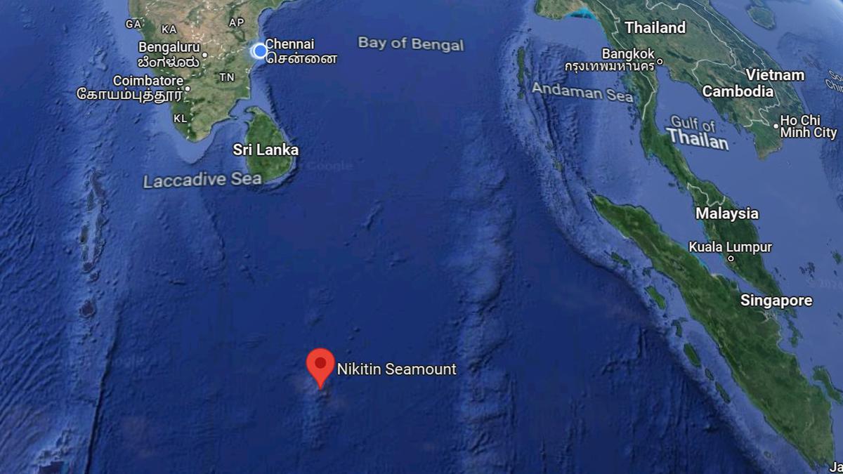
About the Afanasy Nikitin Seamount (ANS) Seabed:
- The ANS is a major structural feature in the Indian Ocean, rising up above the sea bed but below the surface, and forming a seamount.
- It is 400 km long and 150 km wide, and is located in the Central Indian Basin — southeast of Sri Lanka, right below the equator, to the west of Singapore.
- It was formed about 80 million years ago, while dinosaurs still roamed the Earth.
- The Seamount is named after Afanasy Nikitin, a 15th-century Russian merchant who was one of the first to document his travels to India.
- A black monolith is also erected in his honor at Revdanda, about 100 km away from Mumbai, where he is thought to have first set foot in the country.
- The ANS seamount is about 3,000 km from India’s coast and is rich in cobalt, copper, manganese, and nickel.
What are Seamounts?
- Seamounts are submarine mountains originating from volcanic eruptions beneath the ocean's surface, serving as critical habitats for diverse marine ecosystems.
- Similar to terrestrial volcanoes, seamounts can exhibit varying states of activity, including active, dormant, or extinct stages.
- They typically form near mid-ocean ridges, where tectonic plates separate, allowing magma to ascend and solidify on the seabed.
- Notably, seamounts also emerge near intraplate hotspots and oceanic island chains, such as island arcs, characterized by volcanic and seismic activity.
- These underwater formations hold significant scientific value, offering insights into mantle composition, plate tectonics, and oceanic circulation dynamics.
- Moreover, seamounts play a crucial role in nutrient cycling and marine life proliferation, fostering localized upwelling of nutrient-rich waters that support diverse biological communities.
Netravati River
- 23 Mar 2024
Why is it in the News?
The principal bench of the National Green Tribunal (NGT) in New Delhi has initiated action on the Netravati Waterfront Promenade Development Project in Mangaluru.
About the Netravati River:
- The Netravati River, also known as Netravathi Nadi, originates from the Bangrabalige valley, Yelaneeru Ghat in Kudremukh, Chikkamagaluru district, Karnataka, India.
- It passes through the revered pilgrimage site Dharmasthala, earning recognition as one of India's sacred rivers.
- Converging with the Kumaradhara River at Uppinangadi, it eventually flows into the Arabian Sea, south of Mangalore city, serving as the primary water source for Bantwal and Mangalore.
- The Netravati railway bridge, a prominent structure, acts as the gateway to Mangalore.
- Historically known as the Bantwal River, it was documented as unfordable during the South-West Monsoon in the 1855 Gazetteer of Southern India.
- The river's navigability by small country craft and its influence on local geography and transport, including the naming of the Netravati Express train, underscores its significance in the region's history.
- Instances of flooding, notably in 1928 and 1974, have shaped the lives of residents, prompting relocations and resilience
About the National Green Tribunal:
- The National Green Tribunal (NGT) was established under the National Green Tribunal Act of 2010.
- While its principal seat is located in New Delhi, it also holds sessions in Bhopal, Pune, Kolkata, and Chennai.
- The NGT is entrusted with the responsibility of adjudicating applications or appeals, ensuring their final disposition within six months of filing.
Composition:
- The tribunal comprises a Chairperson, Judicial Members, and Expert Members, each serving a non-renewable term of five years.
- The appointment of the Chairperson is made by the Central Government in consultation with the Chief Justice of India (CJI).
- A Selection Committee, constituted by the Central Government, is responsible for appointing both Judicial and Expert Members.
- The tribunal can accommodate a minimum of 10 and a maximum of 20 full-time Judicial and Expert Members.
Powers & Jurisdiction:
- Established to efficiently handle cases concerning environmental protection and conservation of natural resources, including forests.
- It possesses appellate jurisdiction akin to a court.
- While not bound by the procedural formalities outlined in the Code of Civil Procedure, 1908, the NGT operates based on the principles of natural justice.
Earth’s early evolution: Fresh insights from rocks formed 3.5 billion years ago
- 23 Feb 2024
Why is it in the News?
Exploring ancient cratons such as the Singhbhum Craton in India, alongside similar formations in South Africa and Australia, provides unparalleled insights into the early stages of our planet's development, reaching back approximately 3.5 billion years.
What is Singhbhum Craton?
- The Singhbhum Craton encompasses a vast expanse of rugged terrain, primarily spanning regions in Jharkhand and Odisha, situated between the Chhota Nagpur plateau and the Eastern Ghats.
- Dating back approximately 3.5 billion years, this ancient segment of the Earth's crust offers valuable insights into early geological processes.
- Its oldest rock formations consist predominantly of volcanic and sedimentary rocks, referred to as greenstone successions.
- Greenstones are characterised by submarine volcanic rocks with minor sedimentary components.
- Geologically akin to greenstone belts in South Africa's Barberton and Nondweni regions and the Pilbara Craton in Western Australia, these areas experienced extensive submarine mafic volcanic activity, rich in magnesium oxide, between 3.5 and 3.3 billion years ago, with preserved features like pillowed lava and komatiites.
Significance:
- The Singhbhum Craton sheds light on early tectonic activities during the Archaean era, enhancing our understanding of the Earth's formative stages.
- Its distinctive geological characteristics, particularly the presence of greenstone belts, yield invaluable data on surface and atmospheric processes crucial for theorising about early habitable conditions and the emergence of life on Earth.
What are Cratons?
- A craton is a stable and ancient part of Earth's lithosphere that has experienced long-term tectonic and geomorphic stability.
- It is considered to be the nucleus of a continent and is characterised by its thick and cold lithosphere.
- Cratons can undergo destruction, which is defined as a geological process resulting in the loss of craton stability due to changes in its physical and chemical properties.
- The mechanisms responsible for craton destruction include oceanic plate subduction, rollback and retreat of subducting plates, stagnation and dehydration of subducting plates in the mantle transition zone, melting of the mantle caused by dehydration of stagnant slabs, non-steady flow in the upper mantle induced by melting, and changes like the lithospheric mantle.
- Craton destruction can lead to crustal thinning, surface uplift, and the concentration of mineral deposits.
La Nina impacted air quality in India in the winter of 2022
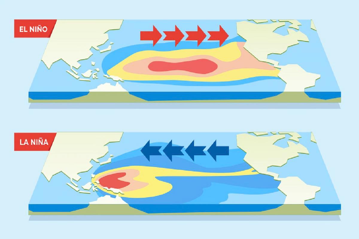
- 20 Feb 2024
Why is it in the News?
A new study suggests that monsoon rainfall over India, which is strongly influenced by El Niño and La Niña events—alternating warming and cooling of the eastern Pacific Ocean impacting global weather may also affect air quality in the country.
Key Findings of the New Study on the Impact of La Niña on Air Quality in India:
- According to the researchers at the National Institute of Advanced Studies (Bengaluru) and the Indian Institute of Tropical Meteorology (Pune), the strong influence of El Niño and La Niña events on monsoon rainfall over India, driven by the alternating warming and cooling of the eastern Pacific Ocean, with far-reaching effects on global weather patterns.
- Remarkably, this study marks the first time that air quality in Indian cities has been directly linked to a La Niña event, suggesting an indirect connection to climate change, which intensifies the severity of El Niño and La Niña occurrences.
- Traditionally, northern Indian cities, notably Delhi, face elevated concentrations of PM2.5 pollutants from October to January.
- However, the winter of 2022 witnessed a notable deviation from this trend, with northern cities experiencing cleaner air than usual, while western and southern cities like Mumbai, Bengaluru, and Chennai saw worsened air quality.
- Specifically, Delhi observed a 10% reduction in PM2.5 concentrations, contrasted with a 30% increase in Mumbai and a 20% rise in Bengaluru.
- The researchers, investigating this anomaly, identified the potent effects of the La Niña event, notably stronger than typical occurrences, leading to significant changes in wind circulation patterns over India.
- This impact became pronounced in the third year of La Niña, suggesting a cumulative effect that may amplify over time.
- While La Niña events are associated with improved air quality in northern India, the study emphasizes the need for further research to understand the potential impacts of El Niño events, which may produce contrasting effects on air quality across the country.
What are El Niño and La Niña?
- El Niño refers to a band of warmer water spreading from west to east in the equatorial Pacific Ocean.
- Similarly, a La Niña occurs when the band of water spreads east to west and is cooler.
- Both phenomena affect the weather worldwide and can have drastic effects on economies that depend on rainfall.
- Together, El Niño and La Niña make up a cyclical process called the El Niño Southern Oscillation.
- An El Niño year creates a global warming crisis in miniature because the warm water spreading across the tropical Pacific releases a large amount of heat into the atmosphere.
- El Niño: El Niño is characterized by warmer-than-average sea surface temperatures in the central and eastern Pacific Ocean.
- In India, El Niño events often correlate with below-average rainfall during the monsoon season.
- This can lead to drought conditions in some regions, affecting agriculture and water resources.
- El Niño can also influence temperature patterns, with some parts of India experiencing warmer temperatures during El Niño events.
- La Niña: La Niña is characterized by cooler-than-average sea surface temperatures in the central and eastern Pacific Ocean.
- In India, La Niña events often correlate with above-average rainfall during the monsoon season.
- This can lead to increased precipitation in some regions, potentially causing flooding, while other areas may experience drought conditions.
- La Niña can also influence temperature patterns, with some parts of India experiencing cooler temperatures during La Niña events.
Impact of La Niña on Air Quality in India:
- Altering Wind Patterns: During the winter of 2022, the typical north-westerly winds, carrying agricultural pollutants from Punjab and Haryana towards Delhi and the Gangetic plains, were disrupted.
- Instead, wind circulation shifted to a north-south direction, diverting pollutants away from Delhi.
- Consequently, pollutants bypassed Delhi, travelling over Rajasthan and Gujarat towards southern regions.
- Modifying Local Wind Circulation near Mumbai: In Mumbai, the local wind circulation, which alternates between land-to-sea and sea-to-land flows every few days, experienced prolonged unidirectional winds.
- This sustained wind pattern prevented the dispersal of pollutants from the city, leading to their accumulation within Mumbai's atmosphere throughout the winter of 2022.
- These changes in wind patterns, influenced by La Niña, significantly impacted air quality dynamics in India, highlighting the intricate relationship between climate phenomena and regional atmospheric conditions.