Krishi Integrated Command and Control Centre (ICCC)

- 27 Mar 2024
Why is it in the News?
Earlier this month, Agriculture Minister Arjun Munda inaugurated a Krishi Integrated Command and Control Centre (ICCC) set up at Krishi Bhavan in New Delhi, a big-screen dashboard of all digital innovations in the sector.
What is the Krishi ICCC?
- The ICCC is a tech-based solution involving multiple IT applications and platforms, designed to help make informed decisions.
- The center is housed in the Ministry of Agriculture & Farmers’ Welfare and is responsible for legislation, policy formation, and implementation of initiatives in the agriculture sector.
- The ICCC uses state-of-the-art technologies such as artificial intelligence, remote sensing, and Geographic Information Systems (GIS) to collect and process large amounts of granular data.
- The ICCC uses platforms including the Krishi Decision Support System (DSS) to collect micro-level data, process it, and present the macro picture.
How does the Krishi ICCC Operate?
- Using AI and machine learning, the system will initially identify a farmer either through their mobile number or Aadhaar details.
- Next, it will cross-reference this information with the farmer's field data retrieved from land records, as well as historical crop sowing data from the crop registry, and weather information from IMD, among other sources.
- Subsequently, the system will generate personalized advisories tailored to the farmer's needs, presented in their local language.
- This functionality will be facilitated through the Bhashini platform, enabling translations into multiple Indian languages.
What Information Does the Krishi ICCC Offer?
- Displayed on eight expansive 55-inch LED screens within the ICCC, the system provides comprehensive data covering various aspects such as temperatures, rainfall, wind speed, crop yields, production statistics, drought conditions, cropping patterns (both geographically and over time), and production forecasts.
- This information is presented in a graphical, map-based, timeline, and drill-down formats for enhanced visualization and analysis.
- Additionally, users can access pertinent trends, including periodic and non-periodic variations, outliers, and Key Performance Indicators (KPIs), alongside receiving insights, alerts, and feedback concerning agriculture schemes, programs, projects, and initiatives.
- Moreover, the system facilitates direct interaction between farmer beneficiaries and officials or the Minister through video conferencing facilities, ensuring effective communication and support.
Practical Applications:
- Farmer’s Advisory: The ICCC allows visualization of GIS-based soil carbon mapping as well as soil health card data for a particular district together in one place.
- This, when visualized with weather-related data from IMD for the selected district, will allow a customized and authentic advisory to be sent to the farmer about the type of crops that can be grown, and water and fertilizer requirements.
- Drought Actions: An increase or decrease in yield from a specific region (as per GCES data) can be correlated with weather, rainfall, and other information visualized through the Drought Portal, enabling the administration to understand the reason for the increase/ decrease in yield and to take decisions proactively.
- Crop Diversification: An analysis of crop diversification maps, together with field variability for paddy, will enable decision-makers to identify regions with scope for diversified cropping so that farmers can be advised accordingly.
- Farm Data Depository: Krishi Decision Support System (K-DSS), a platform under development, will act as an agriculture data repository. Integrated spatial and non-spatial data will be superimposed as a layer on the GIS map, and various AI/ ML models will be run on the data.
- The K-DSS will help in evidence-based, efficient, and data-driven decision-making, and assist in preparing customized advisories for farmers.
- Validation of Yield: Yield, as captured through Krishi MApper, can be analyzed with the yield generated through GCES application for a plot.
Archaeological Survey of India will ‘Delist’ Some ‘Lost’ Monuments
- 27 Mar 2024
Why is it in the News?
The Archaeological Survey of India (ASI) has decided to delist 18 “centrally protected monuments” because it has assessed that they do not have national importance.
Context:
- ASI has decided to delist 18 protected monuments
- ASI says the monuments have ceased to be of 'national importance'
- The 18 'lost' monuments include eleven in Uttar Pradesh
Significance of Delisting Monuments:
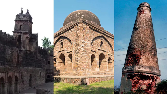
- Several monuments are currently facing the prospect of delisting, including historical landmarks such as a medieval highway milestone in Mujessar village, Barakhamba Cemetery in Delhi, Gunner Burkill’s tomb in Jhansi district, a cemetery at Gaughat in Lucknow, and Telia Nala Buddhist ruins in Varanasi.
- The exact whereabouts or condition of these monuments remain uncertain.
Meaning of Delisting:
- Delisting a monument entails its removal from the roster of protected sites, thereby relinquishing its conservation, protection, and maintenance responsibilities by the Archaeological Survey of India (ASI).
- Under the Ancient Monuments and Archaeological Sites and Remains (AMASR) Act, delisted monuments no longer enjoy protection against construction-related activities in their vicinity, enabling regular urbanization and development activities to proceed uninhibited.
Status of Protected Monuments:
- The inventory of protected monuments is subject to change through additions and removals. Presently, the ASI oversees 3,693 monuments, a number set to decrease to 3,675 following the ongoing delisting initiative.
- This marks the first extensive delisting endeavor in several decades.
Procedures for Monument Delisting:
- The regulations governing the List of Protected Monuments are stipulated under the Ancient Monuments and Archaeological Sites and Remains Rules, 1959.
- This legislation safeguards structures and sites aged over a century, encompassing a diverse array of architectural and historical marvels.
- The government possesses the authority to eliminate certain monuments from the protected list via official notification in the Gazette.
- Through such notifications, the government can declare that certain ancient monuments, archaeological sites, or relics no longer hold national significance under the purview of the AMASR Act (Section 35 of the AMASR Act).
Lost Monuments:
- The Ancient Monuments and Archaeological Sites and Remains (AMASR) Act safeguards monuments and sites aged over a century.
- Nevertheless, numerous structures, particularly smaller or lesser-known ones, have gradually disappeared over time due to factors like urbanization, encroachments, dam and reservoir construction, or neglect.
- In some instances, the lack of public memory hampers efforts to locate these monuments.
Extent of Loss:
- According to a submission by the Ministry of Culture to the Parliamentary Standing Committee on Transport, Tourism, and Culture in December 2022, 50 out of India's 3,693 centrally protected monuments were unaccounted for.
- Among these, 14 succumbed to rapid urbanization, 12 were submerged by reservoirs or dams, and the remaining 24 remain untraceable.
- The Committee noted that budget constraints limited the provision of security guards to historical sites, with only 2,578 guards assigned to 248 sites out of the required 7,000.
- Additionally, a 2013 report by the Comptroller and Auditor General (CAG) of India highlighted the disappearance of at least 92 centrally protected monuments nationwide.
About the Archaeological Survey of India (ASI):
- Founded in 1861 by Alexander Cunningham, the Archaeological Survey of India (ASI) was later formalized as a statutory body under the Ancient Monuments and Archaeological Sites and Remains Act, 1958 (AMASR Act) following India's independence.
- ASI's primary mandate encompasses archaeological research and the safeguarding, conservation, and preservation of cultural monuments across the nation.
- Its operational scope includes conducting surveys of antiquarian remains, exploring and excavating archaeological sites, and overseeing the conservation and maintenance of protected monuments, among other responsibilities.
- The ASI operates under the purview of the Ministry of Culture.
Armed Forces (Special Powers) Act (AFSPA)

- 27 Mar 2024
Why is it in the News?
Union Home Minister Amit Shah has said the Jammu and Kashmir Assembly elections will be held before September and that the Centre will consider revoking the Armed Forces (Special Powers) Act there.
What is AFSPA?
- The AFSPA empowers the armed forces to uphold law and order in “disturbed areas.”
- They have the right to prevent a gathering of five or more people in a given location, use force, or even open fire after providing a sufficient warning if they believe someone is breaking the law.
- Armed forces are also permitted to enter and search any location if they suspect illegal activity.
- According to the AFSPA Act, the Army also has the authority to detain someone without a warrant, seize weapons and ammunition, and offer protection to someone acting in good faith.
Salient features of the AFSPA Act:
- The Central Government or the Governor of a State has the right to declare all or a part of any state to be a disturbed region if they believe it is necessary to stop the terrorist activity or any other activity that could jeopardize India’s sovereignty or be disrespectful to the national anthem, flag, or constitution.
- According to Section 3 of the AFSPA, the Central Government may send out armed forces to support the civilian authorities if the governor of a state publishes a formal announcement in the Gazette of India.
- According to the Disturbed Areas Act of 1976, a territory must maintain the status quo for a minimum of three months after being designated “disturbed.”
- Section (4) of the AFSPA grants army officers specific authority to shoot the only requirement is that the officer must sound the alarm before firing.
- Security forces have the authority to search without permission and arrest anyone without a warrant.
- After being taken into custody, a person must be delivered to the closest police station as soon as possible.
- The Central Government must first provide its consent before prosecuting an on-duty officer for alleged human rights violations.
What are the “Disturbed areas” under the AFSPA Act?
- The state governor, the administrator of the union territory, or the central government may declare a region as a “disturbed area” by publishing a notice in the official gazette, the entire territory or an order to implement it may be declared disturbed.
- It is up to the state governments to decide whether or not to implement the Act.
- However, the governor or the Center may disregard their judgment under Section (3) of the Act.
- The state governor was the only person with the authority to confer AFSPA when the act came into force in 1958.
- The 1978 amendment granted the central government this authority.
List of states that implement the AFSPA Act:
- Four states and one union territory currently have AFPSA activities, while 12 districts are still partially subject to the act, and 31 districts have fully implemented the law.
The AFSPA states include:
-
- Jammu & Kashmir
- Nagaland
- Assam
- Arunachal Pradesh
- Manipur
Black Carbon
- 27 Mar 2024
Why is it in the News?
As per a study, the residential sector is responsible for 47% of India's overall black carbon emissions.
What is Black Carbon?
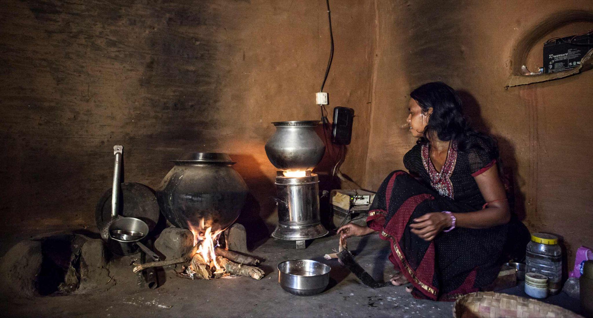
- Black carbon is the dark, sooty material emitted alongside other pollutants when biomass and fossil fuels are not fully combusted.
- It contributes to global warming and poses severe risks.
- Studies have found a direct link between exposure to black carbon and a higher risk of heart disease, birth complications, and premature death.
- Most black carbon emissions in India arise from burning biomass, such as cow dung or straw, in traditional cookstoves.
- According to a 2016 study, the residential sector contributes 47% of India’s total black carbon emissions.
- Industries contribute a further 22%, diesel vehicles 17%, open burning 12%, and other sources 2%.
- Decarbonization efforts in the industry and transport sectors in the past decade have yielded reductions in black carbon emissions, but the residential sector remains a challenge.
- Black carbon is a potent contributor to global warming due to its efficient absorption of light and subsequent heating of its surroundings.
- This process leads to the conversion of incoming solar radiation into heat.
- Moreover, black carbon influences cloud formation and affects regional circulation and precipitation patterns.
- When deposited on ice and snow, it diminishes surface albedo, reducing their ability to reflect sunlight and causing surface warming.
Impacts:
- Black carbon significantly contributes to global warming and poses substantial risks to human health.
- Exposure to black carbon has been linked to increased incidences of heart disease, birth complications, and premature mortality.
- Its warming effect on climate is estimated to be 460-1,500 times more potent than that of CO2.
Magnetofossils
- 27 Mar 2024
Why is it in the News?
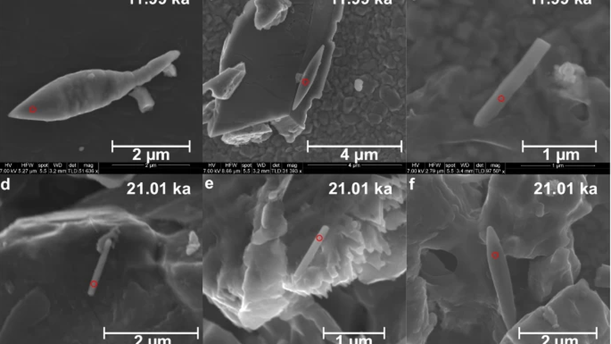
In the depths of the Bay of Bengal, scientists have discovered a 50,000-year-old sediment — a giant magnetofossil and one of the youngest to be found yet.
What are Magnetofossils?
- Magnetofossils represent the fossilized remnants of magnetic particles originated by magnetotactic bacteria, also referred to as magnetobacteria, encapsulated within the geological archives.
About Magnetotactic Bacteria:
- Magnetotactic bacteria, predominantly prokaryotic microorganisms, possess the unique ability to align themselves in alignment with Earth's magnetic field.
- These organisms were traditionally believed to utilize the Earth's magnetic field as a navigational aid to locate environments with optimal oxygen levels.
- Comprising distinctively structured particles abundant in iron, these bacteria harbor small sacs that function akin to a compass.
- Magnetotactic bacteria synthesize minute crystals composed of iron-rich minerals such as magnetite or greigite, facilitating their navigation amidst fluctuations in oxygen concentrations within their aquatic habitats.
Key Findings of the Study:
- Sediment Composition: The sediment core, measuring three meters in length and extracted from the southwestern Bay of Bengal, primarily comprised "pale green silty clays."
- Foraminifera Abundance: Researchers observed abundant benthic and planktic foraminifera, which are single-celled organisms characterized by shells found near the seabed and freely floating in water.
- Oxygen Concentration: At depths ranging from approximately 1,000 to 1,500 meters, the Bay of Bengal exhibited notably low oxygen levels.
- Analysis of the sediment sample confirmed fluctuations in monsoon activity, as evidenced by the presence of magnetic mineral particles from distinct geological periods.
- Role of Rivers: Rivers such as the Godavari, Mahanadi, Ganga-Brahmaputra, Cauvery, and Penner, which discharge into the Bay of Bengal, played a pivotal role in magnetofossil formation.
- Nutrient Supply: The nutrient-rich sediment transported by these rivers supplied reactive iron, which, combined with organic carbon in the suboxic conditions of the Bay of Bengal, created a conducive environment for magnetotactic bacteria growth.
- Impact of Oceanographic Processes: Factors such as freshwater discharge from rivers and oceanographic phenomena like eddy formation influenced the oxygen content in these waters, distinguishing them from other low-oxygen zones.
- Persistence of Suboxic Conditions: The presence of magnetofossils indicated the prolonged persistence of suboxic conditions in the Bay of Bengal, fostering an environment conducive to the proliferation of magnetotactic bacteria.