Solar Storms
- 15 May 2024
Why is it in the News?
According to the Indian Space Research Organisation (ISRO), Indian satellites did not suffer any major outages due to the multiple powerful earth-bound solar storms recently.
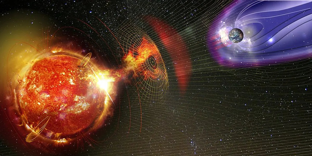
What is a Solar Storm?
- Solar storms are a normal part of our Sun's solar cycle.
- It occurs when the Sun emits huge bursts of energy in the form of solar flares and coronal mass ejections.
- These phenomena send a stream of electrical charges and magnetic fields toward the Earth at a speed of about three million miles per hour.
- When a solar storm strikes the Earth, it often produces a dazzling “northern lights" display in parts of the atmosphere that can be seen in areas close to the Arctic Circle.
- Solar storms start with a huge explosion on the Sun.
- These explosions — called solar flares — can be about as powerful as billions of nuclear bombs!
- Solar flares usually go hand-in-hand with the release of huge streams of charged plasma that travel at millions of miles per hour.
- These streams are called coronal mass ejections, or CMEs.
- When CMEs hit the Earth, they can cause geomagnetic storms that disrupt satellites and electrical power grids.
- For example, in 2017 two massive solar flares fired out from the surface of the Sun disrupted devices such as GPS navigation systems on Earth.
How often do solar storms happen?
- Scientists who study solar storms have discovered that the frequency of solar flares appears to follow an 11-year solar cycle.
- At times of peak activity, there could be several solar storms each day.
- At other times, there might be less than one solar storm per week.
What is the Impact of Solar Storm?
- It majorly interferes with several services, including GPS navigation, weather forecasting, communication, and other satellite-dependent services.
- Besides that, it also has a significant impact on satellite networks and communication.
- They can create geomagnetically induced currents (GICs), which can overload electrical systems and cause damage to transformers, issues with voltage regulation, and widespread power outages.
- Furthermore, because solar storms increase the amount of solar and cosmic radiation that reaches the top regions of Earth's atmosphere, they also pose health concerns to people, especially aircraft crew and passengers, especially on flights at high latitudes.
- These storms have the potential to disrupt infrastructure in near-Earth orbit and on Earth's surface, affecting communications, the electric power grid, navigation, radio, and satellite operations.
Humboldt Glacier
- 15 May 2024
Why is it in the News?
Venezuela is thought to be the first nation in modern times to have completely lost all of its glaciers.
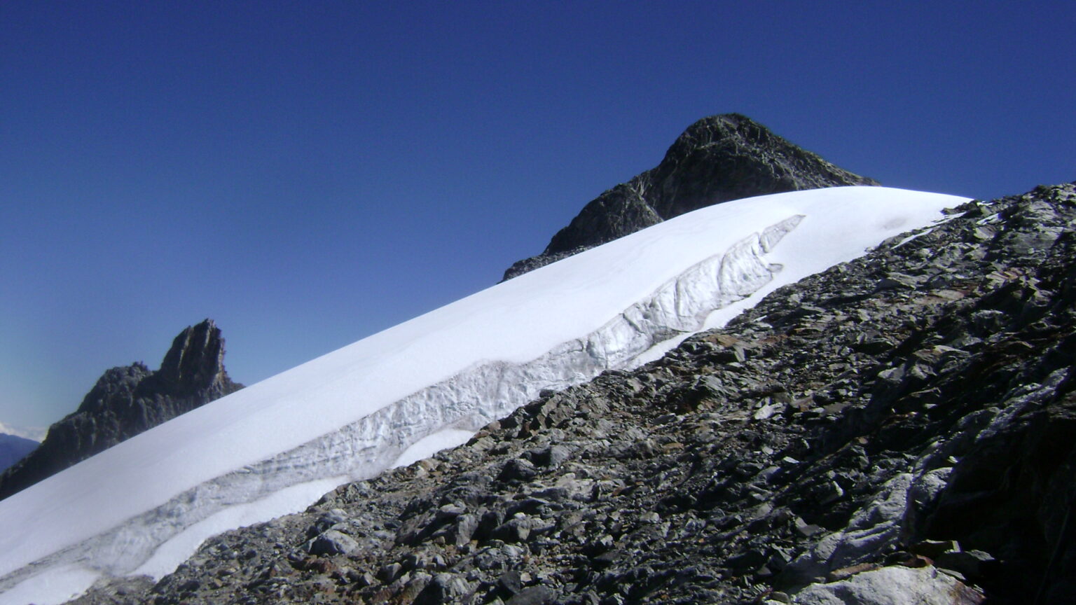
About Humboldt Glacier:
- Venezuela's Humboldt Glacier, also known as La Corona, held great significance as the country's last remaining glacier.
- Located in the Sierra Nevada de Mérida mountain range in the Andes, at an altitude of approximately 5,000 meters, the Humboldt Glacier was part of a group of six glaciers that once covered an area of 10 square kilometres.
- However, due to the accelerated melting caused by climate change, five of these glaciers had vanished by 2011, leaving Humboldt as the sole remnant.
- Humboldt Glacier's deterioration continued at an alarming pace in subsequent years.
- Recent studies conducted by the International Cryosphere Climate Initiative (ICCI), a scientific advocacy organization, revealed that the glacier had shrunk to an area of less than 2 hectares.
- As a result, it was downgraded from a glacier to an ice field, marking Venezuela as the first country in modern history to lose all of its glaciers.
- The demise of Humboldt Glacier serves as a stark warning of the global consequences of climate change.
- It exemplifies the rapid loss of ice in tropical regions, which not only impacts local ecosystems and water resources but also contributes to rising sea levels and exacerbates the effects of climate change worldwide.
About the International Cryosphere Climate Initiative (ICCI):
- International Cryosphere Climate Initiative (ICCI) was formed in 2009 following COP-15 in Copenhagen.
- It is a network of senior policy experts and researchers working with governments and organizations to create, shape and implement initiatives designed to preserve as much of the Earth’s cryosphere as possible.
- CCI's work focuses on three major areas of the cryosphere:
- The Arctic
- The Antarctic
- High mountain regions
- By connecting cutting-edge science to a variety of policy-making forums and supporting integrated projects worldwide to protect the cryosphere, ICCI advances climate action.
- ICCI programs target the unique climate dynamics at work in the cryosphere, while at the same time lending increased urgency to global climate efforts aimed at CO2 and other greenhouse gases by communicating the unexpected rapidity and global implications of cryosphere warming.
NISAR Satellite Can Monitor Earth’s Tectonic Movements
- 15 May 2024
Why is it in the News?
ISRO Chairman S. Somanath recently announced that the NISAR satellite has the capability to accurately monitor tectonic movements and complete full mappings of the Earth twice a month.
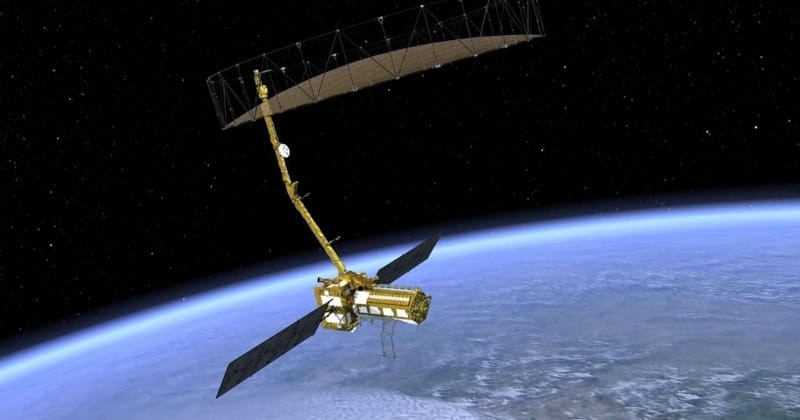
About the NISAR Satellite:
- NISAR is a joint Earth-observing mission between NASA and the Indian Space Research Organization (ISRO).
- It is a Synthetic Aperture Radar satellite with two bands.
- It will be launched into a polar Sun-synchronous dawn-dusk orbit.
- One is the S-band and the other is the L-band.
- The S-band payload has been made by the ISRO and the L-band payload by the U.S.
- The U.S. will contribute to the large deployable antenna.
- This being a dual-band polarizable radar, it can do a lot of things.
- First, because it has a large deployable antenna with an 18-metre diameter, it has a very high swath.
- It can fully cover the earth in approximately 14 to 15 days, according to radar.
- It can monitor various aspects in very high resolution.
- For example, it can monitor the tectonic movements to centimetre accuracy.
- It can do measurements of water bodies accurately.
- It can look at water stressing on the earth, wherever there is a deficiency of water.
- It can ground-penetrate to a certain depth.
- It is capable of monitoring the vegetation cover and snow cover.
- It, therefore, basically looks at the whole of the earth in terms of surface, water, greenery and all of that.
- It measures accurately and gives repetitive, full coverage of the earth two times a month.
- It means it is capable of a lot of observation and this data will be available to both India and the U.S.
- We can study the water-stressing, climate change-related issues, and agricultural changes through patterns, yield, desertification and continental movements precisely with respect to annual water cycle movements.
- It can measure tectonic plate movements accurately.
- So a lot of geological, agricultural and water-related observations can be obtained from this satellite.
Mission Objectives:
- The primary goal of NISAR is to provide precise measurements of tectonic plate movements, enabling comprehensive observations in geology, agriculture, and water-related domains.
- Additionally, it aims to analyze water stress, climate change impacts, agricultural shifts, desertification, and continental shifts with accuracy, particularly concerning annual water cycle variations.
- NISAR's data will facilitate global resource and hazard management, while also aiding scientists in comprehending climate change dynamics and its effects.
Launch Schedule:
- Initially planned for July, the launch is now expected in October-November due to issues on the U.S. side requiring corrections.
Memory of the World (MoW) Programme
- 15 May 2024
Why is it in the News?
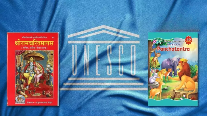
Three Indian literary works, Ramcharitmanas, Panchatantra, and Sah?dayaloka-Locana, were added to UNESCO’s Memory of the World Asia-Pacific Regional Register during the tenth meeting of the Memory of the World Committee for Asia and the Pacific (MOWCAP).
About Memory of the World Programme:
- The Memory of the World (MoW) Programme is an international initiative by UNESCO launched in 1992 aimed at preserving and recognizing the world's significant documentary heritage.
- The program's objective is to identify and protect important documents in a manner similar to how UNESCO's World Heritage Convention and World Heritage List recognize significant natural and cultural sites.
The Memory of the World Programme aims to:
-
- Facilitating the preservation of documentary heritage, particularly in conflict-affected areas or regions impacted by natural disasters.
- Enabling universal access to documentary heritage worldwide.
- Enhancing public awareness about the significance of documentary heritage among the wider public.
Governance Body:
- The International Advisory Committee (IAC) serves as the main governing body for the MoW Programme, providing guidance to UNESCO on its planning and implementation.
- The IAC comprises 14 members appointed by UNESCO's Director-General, who are chosen for their expertise and authority in the field of documentary heritage.
Nominations for MoW:
- Nominations for inscription on the Asia Pacific Register are called every two years, alternating with the International Register.
- In even-numbered years, nominations are accepted for the Asia Pacific Register.
India has three items included in the Memory of the World Register:
- Ramcharitmanas: Written by Tulasidas in the 16th century in the Awadhi dialect, this text holds immense cultural and literary significance in the regions of Lucknow, Prayagraj, and Ayodhya.
- Panchatantra: This ancient Indian collection of fables, originally written in Sanskrit, consists of five sections that revolve around specific principles.
- It is widely believed to have been authored by Vishnu Sharma.
- Sah?day?loka-Locana: A Sanskrit commentary on the Dhvanyaloka, Sah?day?loka-Locana holds significant historical and literary value within India's rich cultural landscape.
- Through the Memory of the World Programme, UNESCO continues to protect and celebrate the diverse documentary heritage of humanity, ensuring its preservation and accessibility for future generations.
Indian Cyber Crime Coordination Centre (I4C)
- 15 May 2024
Why is it in the News?
The Indian Cyber Crime Coordination Centre (I4C), in collaboration with Microsoft, has blocked more than 1,000 Skype IDs involved in blackmail, extortion, and “digital arrests” by cybercriminals posing as police and law enforcement authorities.
About Indian Cyber Crime Coordination Centre (I4C):
- The Indian Cyber Crime Coordination Centre (I4C) is a comprehensive initiative to address cybercrime in India.
- It has been established under the Ministry of Home Affairs (MHA) Govt. of India.
- With a focus on improving coordination between various Law Enforcement Agencies (LEAs) and stakeholders, I4C serves as a nodal point in the fight against cybercrime.
- It is located in New Delhi.
Its primary functions include:
- Acting as the central hub for tackling cybercrime and coordinating efforts among LEAs.
- Identifying research needs and collaborating with academia and research institutes within India and abroad to develop new technologies and forensic tools.
- Preventing the misuse of cyberspace by extremist and terrorist groups.
- Suggesting amendments to cyber laws to keep pace with evolving technologies and fostering international cooperation.
- Coordinating activities related to the implementation of Mutual Legal Assistance Treaties (MLAT) with other countries concerning cybercrimes, in consultation with the concerned nodal authority in MHA.
Key Components of the Indian Cyber Crime Coordination Centre (I4C):
- The I4C is comprised of several specialized units designed to tackle various aspects of cybercrime:
- National Cybercrime Threat Analytics Unit (TAU): Regularly reports on cybercrime threats and provides crucial insights to support the nation's cybersecurity efforts.
- National Cybercrime Reporting Portal (NCRP): Offers a unified platform for citizens to report various cybercrime complaints around the clock from anywhere in India.
- National Cybercrime Training Centre (NCTC): Imparts essential training to government officials, primarily focusing on state law enforcement agencies.
- National Cybercrime Research and Innovation Centre: Conducts research and develops indigenous tools for preventing cybercrimes.
- Platform for Joint Cyber Crime Coordination Team: Facilitates coordination, sharing of cybercrime modus operandi, and data/information exchange among state/UT LEAs.
- Cybercrime Ecosystem Management Unit: Focuses on creating mass awareness regarding cyber hygiene and prevention of cybercrimes.
- National Cybercrime Forensic Laboratory (Investigation) Ecosystem: Assists LEAs in cyber forensics investigations.
- In addition to these components, the I4C also fosters collaboration between academia, industry, the public, and government entities in the prevention, detection, investigation, and prosecution of cybercrimes.
- Through the Cyber Crime Volunteers Program, the I4C unites passionate citizens who are committed to serving the nation and contributing to the fight against cybercrime.