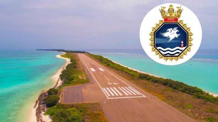
INS Jatayu, India’s new naval base in Lakshadweep
- 06 Mar 2024
Why is it in the News?
On Wednesday (March 6), Naval Detachment Minicoy will be commissioned as INS Jatayu, an upgraded naval base, marking an important milestone in the Indian Navy’s resolve to incrementally augment security infrastructure at the strategic Lakshadweep Islands.
About INS Jatayu Naval Base:
- The existing Naval Detachment Minicoy, which is under the operational command of the Naval Officer-in-Charge (Lakshadweep), will be commissioned as INS Jatayu.
- A naval detachment has administrative, logistics, and medical facilities.
- INS Jatayu will be upgraded to a naval base with additional infrastructure such as an airfield, housing, and personnel, after obtaining the requisite environmental and other clearances.
- The fragile ecology of the island may pose challenges for the construction but there are plans to construct a new airfield that will be capable of operating both military and civil aircraft.
Significance of INS Jatayu?
- The basing of an independent naval unit with requisite infrastructure and resources will enhance its overall operational capability in the islands.
- The establishment of the base is in line with the government’s focus on comprehensive development of the islands.
- The base will enhance its operational reach, facilitate its anti-piracy and anti-narcotics operations in the western Arabian Sea, and augment its capability as the first responder in the region.
- With the commissioning of INS Jatayu, the Indian Navy will add to its strength on the western seaboard.
- The proposed airfield will allow operations for a range of aircraft, including P8I maritime reconnaissance aircraft and fighter jets, and extend the Navy’s reach and operational surveillance capabilities at a time when India is seeking to counter the growing Chinese influence in the Indian Ocean Region.
- This has an immediate bearing at a time when India’s relations with the Maldives have come under strain since the election of the pro-China President Mohamed Muizzu.
About the Lakshadweep Islands:
- Lakshadweep, ‘a hundred thousand islands’ in Sanskrit and Malayalam, is an archipelago of 36 islands located between 220 km and 440 km from Kochi.
- The islands, only 11 of which are inhabited, have a total area of only 32 sq km.
- The Lakshadweep are part of a chain of coralline islands in the Indian Ocean that includes Maldives to the south, and the Chagos archipelago farther beyond, to the south of the equator.
- Given their location in the Indian Ocean, the Lakshadweep are of huge strategic importance to India.
- Minicoy straddles vital Sea Lines of Communications (SLOCs) — the world’s main maritime highways — including the Eight Degree Channel (between Minicoy and Maldives) and the Nine Degree Channel (between Minicoy and the main cluster of Lakshadweep islands).
- In consequence, the Lakshadweep Islands are also vulnerable to marine pollution.
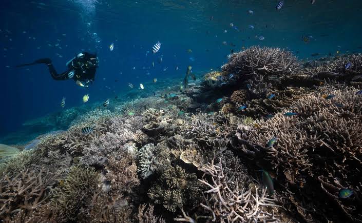
Exclusive-World on brink of fourth mass coral reef bleaching event- NOAA
- 06 Mar 2024
Why is it in the News?
The world stands on the brink of witnessing its fourth mass coral bleaching event, a phenomenon that threatens to hit vast expanses of tropical reefs, including significant portions of Australia's iconic Great Barrier Reef.
Key Findings from the National Oceanic and Atmospheric Administration (NOAA):
- Impending Fourth Mass Coral Bleaching Event: The world is on the brink of a fourth mass coral bleaching event, following those in 1998, 2010, and 2014.
- To classify as global, widespread bleaching must occur across three ocean basins: the Atlantic, Pacific, and Indian.
- Impact of Previous Events: The last global mass coral bleaching event occurred from 2014 to 2017, resulting in the loss of nearly a third of the Great Barrier Reef's corals.
- Preliminary data indicates that approximately 15% of the world's reefs experienced significant coral die-offs during this event.
- Current Situation: This year is witnessing even more severe bleaching events, with the Caribbean experiencing its worst coral bleaching on record following the Northern Hemisphere summer last year.
- Link to Climate Phenomena: Coral bleaching is often associated with the naturally occurring El Niño climate phenomenon, which leads to warmer ocean waters.
- Climate Change Impact: The world recently experienced its first 12-month period with an average temperature exceeding 1.5 degrees Celsius (2.7 degrees Fahrenheit) above pre-industrial levels.
- A temperature rise of 1.5°C is considered the tipping point for mass coral die-offs, with scientists estimating that 90% of the world's corals could be lost as a result.
About the Corals and Coral Reefs:
- Corals: Corals are animals known as polyps, which engage in a symbiotic relationship with tiny algae called zooxanthellae.
- These algae provide corals with food and oxygen, while corals offer them a safe habitat.
- Coral Reefs: Coral reefs are limestone structures formed by thousands of tiny coral animals and are predominantly found in tropical climates.
Coral Bleaching and Its Concerns:
- Coral bleaching occurs when corals are exposed to stressful conditions like high temperatures, pollution, or changes in water chemistry, leading them to expel the zooxanthellae.
- Without these algae, corals lose their color and turn white, hence the term 'bleaching,' and cannot survive for long in this state.
- Recovery Potential: Despite its severity, coral bleaching doesn't necessarily mean the end of the reef; timely removal of stressors can facilitate the return of zooxanthellae and coral recovery.
- Ecological Importance: Coral reefs serve as habitats and food sources for numerous fish and marine species.
- They also offer coastal protection from erosion and storms and play a critical role in regulating the Earth's climate by absorbing and storing carbon dioxide.
- Cultural and Aesthetic Value: Beyond their ecological functions, coral reefs represent stunning biodiversity and natural beauty, making their loss a tragic prospect for future generations.
- Impacts: When coral reefs suffer, so do the ecosystems and communities reliant on them, underscoring the far-reaching consequences of coral degradation.
Google-backed satellite to track global oil industry methane emissions

- 06 Mar 2024
Why is it in the News?
MethaneSAT — a satellite which will track and measure methane emissions at a global scale — was launched aboard a SpaceX Falcon9 rocket from California recently.
What is MethaneSAT?
- MethaneSAT will orbit the Earth 15 times a day, monitoring the oil and gas sector.
- It will create a large amount of data, which will tell “how much methane is coming from where, who’s responsible, and are those emissions going up or down over time”.
- The data collected by MethaneSAT will be made public for free in near real-time.
- This will allow stakeholders and regulators to take action to reduce methane emissions.
Institutions involved in the development:
- The entity behind MethaneSAT is the Environmental Defense Fund (EDF) — a US-based nonprofit environmental advocacy group.
- To develop the satellite, EDF partnered with Harvard University, the Smithsonian Astrophysical Observatory, and the New Zealand Space Agency.
Features of MethaneSAT:
- Historically, tracking the source of methane emissions and measuring them has been quite challenging.
- ?While some satellites can provide high-resolution data, they can only scan specific, pre-targeted sites.
- Others can examine larger areas and detect large emitting events, but cannot scan “smaller sources that account for the majority of emissions in many, if not most, regions,” the EDF statement added.
- Due to this discrepancy, according to an International Energy Agency (IEA) report, global methane emissions are about 70 per cent higher than levels reported by national governments.
- MethaneSAT is expected to fix the issue.
- Equipped with a high-resolution infrared sensor and a spectrometer, the satellite will fill critical data gaps.
- It can track differences in methane concentrations as small as three parts per billion in the atmosphere, which enables it to pick up smaller emissions sources than the previous satellites.
- MethaneSAT also has a wide-camera view — of about 200 km by 200 km — allowing it to identify larger emitters so-called “super emitters”.
Significance of MethaneSAT:
- Advancing the Goals of the Global Methane Pledge 2021: The Global Methane Pledge, signed by over 150 countries in 2021, aims to reduce collective methane emissions by at least 30% from 2020 levels by 2030.
- During the previous year's COP, over 50 companies pledged to significantly reduce methane emissions and routine flaring.
- MethaneSAT will play a crucial role in helping these entities achieve their targets.
- Enhancing Transparency: The satellite will usher in a new era of transparency by providing publicly available data accessible to anyone worldwide.
- This data will enable monitoring of methane commitments made by governments and corporations, promoting accountability and transparency in emission reduction efforts."
Why Do We Need to Track and Measure Methane Emission?
- Methane is an invisible but strong greenhouse gas, and the second largest contributor to global warming after carbon dioxide, responsible for 30 percent of global heating since the Industrial Revolution.
- According to the United Nations Environment Programme, over a period of 20 years, methane is 80 times more potent at warming than carbon dioxide.
- The gas also contributes to the formation of ground-level ozone — a colorless and highly irritating gas that forms just above the Earth’s surface.
- According to a 2022 report, exposure to ground-level ozone could be contributing to one million premature deaths every year.
- Therefore, it is crucial to cut methane emissions and the main culprit, fossil fuel operations, which account for about 40 percent of all human-caused methane emissions.
- The objective of MethaneSAT is to help achieve this goal.
Holistic Progress Card: How NCERT is planning to change student assessment

- 06 Mar 2024
Why is it in the News?
The New Education Policy (NEP), established in 2020, proposed redesigning the assessment system of school students in India recently.
About the Holistic Progress Card (HPC):
- It Is Developed by Performance Assessment, Review, and Analysis of Knowledge for Holistic Development (PARAKH), a standard-setting body under the NCERT.
- The Holistic Progress Card (HPC) marks a significant departure from traditional assessment methods for students in the foundational stage (Classes 1 and 2), preparatory stage (Classes 3 to 5), and middle stage (Classes 6 to 8), aligning with the recommendations of the National Education Policy (NEP) 2020.
Key Features:
- Incorporates feedback from parents, classmates, and self-evaluation by students.
- Aims to provide a comprehensive view of students' academic performance, cognitive abilities, socio-emotional skills, and creativity during class activities.
- Aligns with the National Curriculum Framework for School Education (NCFSE) to prioritize learner-centric evaluation.
- Emphasizes a shift from numerical grades to a 360-degree evaluation, focusing on students' active engagement in class activities and the demonstration of diverse skills and competencies.
- Enables teachers to identify students' strengths and weaknesses, fostering personalized support and intervention.
- Encourages students to reflect on their progress and set academic and personal goals, fostering self-awareness and accountability.
- Involves parents in the learning process, integrating their insights on homework, classroom engagement, and extracurricular activities.
- Includes peer evaluation, allowing students to assess their classmates' contributions to activities.
Benefits:
- Goes beyond numerical grades, providing descriptive and analytical evaluations that encompass academic achievements and critical skill development.
- Promotes a shift from summative to formative assessment, fostering competency-based evaluation and holistic growth.
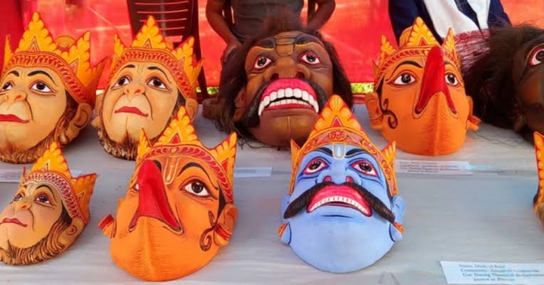
Majuli Island's Mask Craft Celebrated With Geographical Indication Tag
- 06 Mar 2024
Why is it in the News?
Adding to their growing national and international recognition, the traditional Majuli masks in Assam were given a Geographical Indication (GI) tag by the Centre recently.
What are Majuli Masks?
- These handmade masks are traditionally used to depict characters in bhaonas, or theatrical performances with devotional messages under the neo-Vaishnavite tradition.
- Majuli, the largest river island in the world and the seat of Assam’s neo-Vaishnavite tradition, has been home to the art of mask-making since the 16th century.
- It was introduced by the 15th-16th century reformer saint Srimanta Sankardeva.
- The masks can depict gods, goddesses, demons, animals and birds — Ravana, Garuda, Narasimha, Hanuman, Varaha Surpanakha all feature among the masks.
- They can range in size from those covering just the face (mukh mukha), which take around five days to make, to those covering the whole head and body of the performer (cho mukha), which can take up to one-and-a-half months to make.
- According to the application made for the patent, the masks are made of bamboo, clay, dung, cloth, cotton, wood and other materials available in the riverine surroundings of their makers.
Why is This Art Practiced in Monasteries?
- Sattras are monastic institutions established by Srimanta Sankardev and his disciples as centers of religious, social and cultural reform.
- Today, they are also centers of traditional performing arts such as borgeet (songs), sattriya (dance) and bhaona (theater), which are an integral part of the Sankardev tradition.
- Majuli has 22 sattras, and the patent application states that the mask-making tradition is by and large concentrated in four of them:
- Samaguri Sattra
- Natun Samaguri Sattra
- Bihimpur Sattra and
- Alengi Narasimha Sattra
What is Majuli Manuscript Painting?
- It is a form of painting which also received the GI tag.
- It originated in the 16th century done on sanchi pat, or manuscripts made of the bark of the sanchi or agar tree, using homemade ink.
- The earliest example of an illustrated manuscript is said to be a rendering of the Adya Dasama of the Bhagwat Purana in Assamese by Srimanta Sankardev.
- This art was patronized by the Ahom kings.
- It continues to be practiced in every sattra in Majuli.