Landslides in India
- 29 May 2024
Why is it in the News?
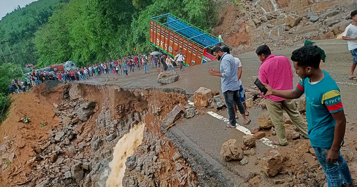
At least 36 people were killed in heavy rains and landslides in four northeastern states on Tuesday under the impact of Cyclone Remal while normal life came to a grinding halt in all the eight states of the region with road and rail links affected.
What are Landslides?
- Landslides in India are one of the major hydro-geological hazards affecting large parts of the landmass of the country.
- It refers to the gravitational movements of a mass of rock, debris, or earth down a slope.
- Landslides are a type of "mass wasting," which denotes any down-slope movement of soil and rock under the direct influence of gravity.
- As per a report from the Geological Survey of India (GSI), 13% of the total land area in India is prone to landslides.
- This covers almost all the hilly regions in the country.
- About 0.18 million square km, or 42% of this vulnerable area is in the Northeastern region, where the terrain is mostly hilly.
What Causes a Landslide in India?
- Deforestation: Removal of trees reduces the binding properties of soil and rocks. This enables the water to seep into the sub-surface, making the topsoil vulnerable.
- For example, the Himalayan region has become more vulnerable to landslides due to the indiscriminate cutting of trees.
- Shifting Cultivation: Shifting cultivation is common in hilly regions and Northeast areas. Every year, residents burn the forests for cultivation purposes.
- However, this deteriorates the quality of topsoil, causing erosion during heavy rainfall. This makes such regions more vulnerable to landslides.
- Heavy Rainfall and Earthquakes: Heavy rainfall and earthquakes often cause landslides.
- For example, heavy rain caused landslides in Talai village of Maharashtra in 2021.
- Mining: Human activities like mining or quarrying remove the vegetation cover and soil gravel. This lowers the groundwater retention capacity. Also, it increases the risk of flooding.
- Therefore, landslides occur due to loose debris or excess floods during an earthquake and heavy rainfall, respectively.
- Urbanisation: Intensive urbanisation and urbanization activities such as establishing commercial housing projects and road construction reduce the vegetation cover which leads to an increasing frequency of landslides.
What Are the Different Types of Landslides?
Landslides in India are divided into four categories:
- Topples: This occurs due to fractures in rocks. It causes tilting for gravitational pull without collapsing.
- Falls: This involves the collapse of rocks or debris from a cliff or slope. It results in the collection of debris at the base of a hill.
- Spread: It occurs in gentle slopes where soft debris or other materials are widely available.
- Slides: It occurs when debris, rocks or soil slide through a slope.
What Are the Impacts of Landslides in India?
- Mud, debris and rocks slide from the slope during landslides.
- This restricts human movement and creates a traffic barrier on highways and railway lines.
- Loss of human lives is one of the severe effects.
- Landslide is the primary factor behind the Joshimath sinking crisis which led to mass evacuation in January 2023.
- It damages houses, roads and buildings.
- This further creates a financial burden for rebuilding infrastructure to rehabilitate the masses.
- The debris sliding down from slopes blocks the river channel fully or partially.
- This makes it difficult for locals to get the water supply.
- Landslides also increase the risk of floods. This is because the debris increases the river sediment.
- As a result, irregular course rivers become frequent, resulting in floods.
What Are the Measures Required to Prevent Landslides?
- An increase in forest cover is a must in community lands to reduce the hazard of landslides.
- People must store the excess water in catchment areas.
- It will reduce the effect of flash floods and also recharge groundwater levels.
- People must restrict the grazing of their animals.
- Reduce the urbanisation activities such as building dams or other commercial projects.
Implementation of public awareness regarding preventive measures during landslides and other hazard management is necessary.
Kaza TFCA (Kavango Zambezi Transfrontier Conservation Area) Summit
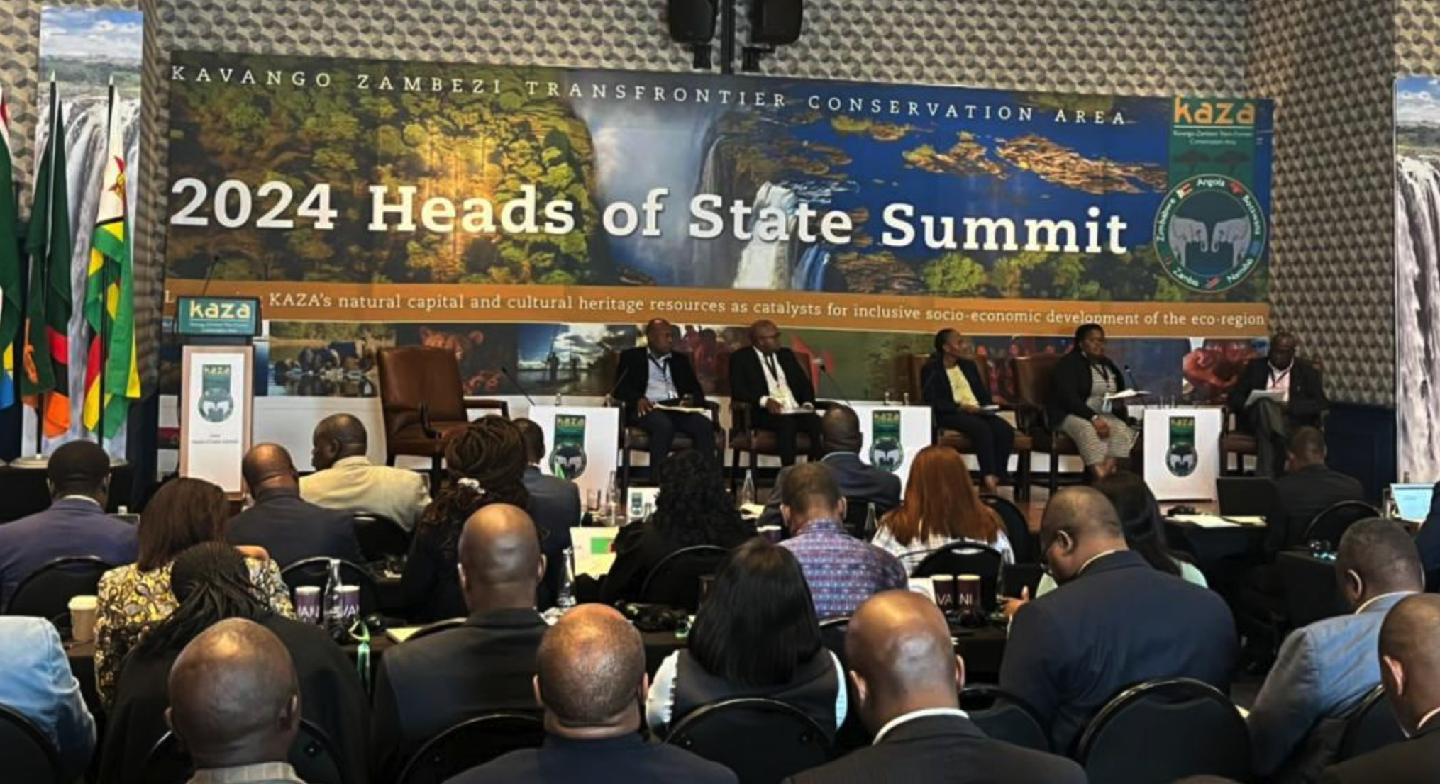
- 29 May 2024
Why is it in the News?
Members states of the world’s largest transnational conservation initiative meet to review progress and strategise the way forward.
About the Kaza TFCA (Kavango Zambezi Transfrontier Conservation Area) Summit:
- The Kaza TFCA (Kavango Zambezi Transfrontier Conservation Area) Summit is a high-level meeting of the heads of state and government representatives from the countries that make up the Kaza TFCA.
- The Kaza TFCA is a conservation area that spans parts of Angola, Botswana, Namibia, Zambia and Zimbabwe.
Some key points about the Kaza TFCA Summit:
- It brings together the political leadership from the five Kaza member countries to discuss issues related to the conservation and sustainable development of the Kaza transfrontier area.
- Topics discussed include wildlife conservation, tourism development, community involvement, and joint management of shared natural resources across international boundaries.
- The Summit aims to strengthen political support, coordination and collaboration among the Kaza partner countries for effective transboundary natural resource management.
- It provides a platform for the member states to review progress made, agree on priorities, and give strategic direction for the Kaza program going forward.
- The Summits are held periodically, with the last one being hosted by Botswana in 2018 in Kasane.
About the Kavango Zambezi Transfrontier Conservation Area:
- The Kavango Zambezi Transfrontier Conservation Area is a 520,000-square-kilometre wetland and spans five southern African countries: Angola, Botswana, Namibia, Zambia and Zimbabwe.
- It is home to a high concentration of wildlife species, including the largest elephant population.
- The KAZA TFCA was formally established on the 18th of August 2011 when the Heads of State of the five governments signed its Treaty in Luanda, Angola, during the SADC Summit for Heads of States.
The KAZA TFCA was established to:
- Conserve the shared natural resources and cultural heritage of this vast area of southern Africa
- Promote and facilitate the development of a complementary and linked network of protected areas that protect wildlife and provide and restore dispersal corridors and migratory routes
- Develop the KAZA TFCA into a world-class tourism destination offering a variety of breathtaking adventures and luxurious relaxation
- Promote the free and easy movement of tourists across borders
- Implement programmes that ensure the sustainable use of natural resources in ways that improve the livelihoods of communities and reduce poverty in the region
- Harmonise conservation legislation and natural resource management of the TFCA
Magellan Mission
- 29 May 2024
Why is it in the News?
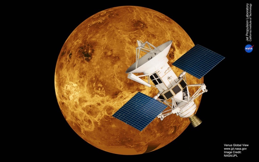
After analysing the archived data from the space agency’s Magellan mission, scientists suggest that Venus, the almost Earth-sized planet was volcanically active between 1990 and 1992.
What is the Magellan Mission?
- NASA's Magellan mission to Venus was one of the most successful deep space missions launched from Kennedy Space Center in Florida in the year 1989.
- It was the first spacecraft to image the entire surface of Venus and made several discoveries about the planet.
- Magellan burned up about 10 hours after being commanded to plunge into the Venusian atmosphere.
- Magellan's primary mission was to use a synthetic aperture radar (SAR) to create detailed maps of the surface of Venus.
- The SAR allowed Magellan to penetrate a thick cloud layer which made it challenging to study Venus from Earth.
- By mapping the planet's surface, scientists aimed to investigate the planet's geology and landforms, including its vast plains, steep mountains, and impact craters.
- Magellan was also sent to measure the planet's gravity and magnetic fields.
- This information was considered important to NASA scientists as it would provide more information about the planet's interior structure and composition.
- Because Venus is a planet close to Earth that compares in size and composition, mapping and studying Venus was considered an important mission as it added to understanding the evolution and geology of rocky planets like Earth.
What is the Magellan Spacecraft?
- The Magellan spacecraft was a space probe launched into space on May 4, 1989, by NASA on the Space Shuttle Atlantis.
- NASA named Magellan after the Portuguese explorer Ferdinand Magellan, who was the first documented person to circumnavigate the Earth.
- The Magellan probe aimed to map the planet Venus and collect data about its atmosphere and physical characteristics.
- Venus is the second planet from the sun in the Milky Way solar system and is, along with Mercury, one of two planets that orbit between Earth and the sun.
- Known for being the first spacecraft to map the surface of Venus, Magellan remained in Venus' orbit for four years before being burned up in its atmosphere in October 1994.
What does the study reveal?
- The study identified a 2.2 square kilometre volcanic vent associated with Maat Mons, the second-highest volcano on Venus, located in the Atla Regio near the planet's equator.
- The vent showed signs of drained lava, and the radar images indicated that it had doubled in size over eight months, with the lava lake seeming to have reached the rim. These changes suggested that the vent had been actively erupting and spewing lava.
This discovery provides new insights into the geology and activity of Venus and highlights the importance of studying the planet's surface features to better understand its history and evolution.
Vivekananda Rock Memorial
- 29 May 2024
Why is it in the News?
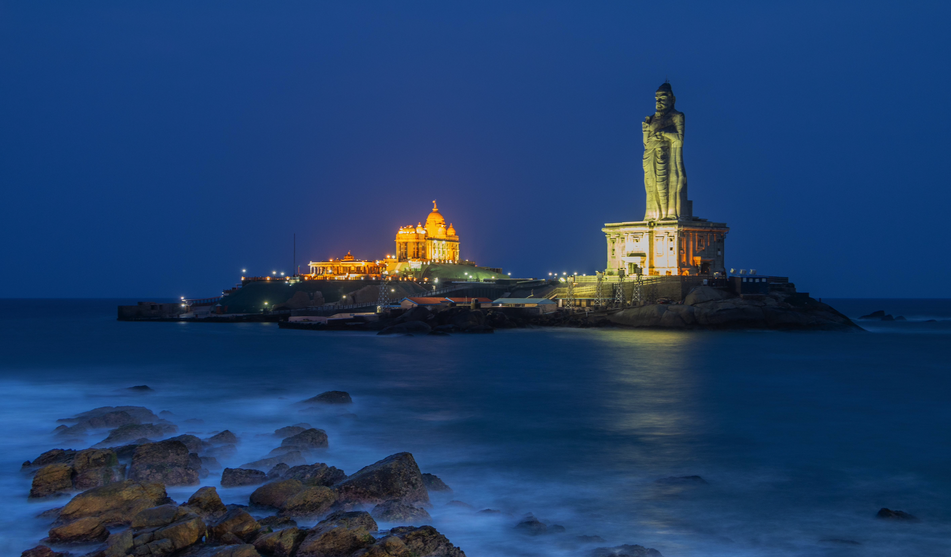
Prime Minister Narendra Modi will be visiting the Vivekananda Rock Memorial in Kanyakumari, to meditate between May 30 to June 1, to mark the culmination of the 2024 Lok Sabha polls.
About the Vivekananda Rock Memorial:
- The Vivekananda Rock Memorial is a monument and a popular tourist destination located approximately 500 metres off the mainland of Vavathurai, Kanyakumari in the state of Tamil Nadu.
- Situated on a big rock, it is surrounded by three water bodies – the Arabian Sea, the Bay of Bengal, and the Indian Ocean.
- Vivekananda is said to have arrived here after wandering across the country.
- It is believed that the monk and the philosopher meditated on the rock and attained a vision for a developed India.
- The memorial, designed by renowned architect Eknath Ranade and completed in 1970, is located at the southernmost point of India in Kanyakumari.
- This is where the eastern and western coastlines of India converge.
- The memorial features two primary structures:
- The Vivekananda Mandapam, which houses an impressive bronze statue of the revered Swami Vivekananda, and
- The Shripada Mandapam contains footprints believed to belong to Goddess Kanyakumari.
- This site holds profound cultural and spiritual significance, with legendary tales of Goddess Kanyakumari praying to Lord Shiva on this rock.
- This memorial is right next to a huge monolithic statue of Tamil poet and philosopher Thiruvalluvar which was created by the Indian sculptor V Ganapati Sthapati.
About Swami Vivekananda:
- Swami Vivekananda (1863–1902), born Narendranath Datta, was a renowned Hindu monk and spiritual leader.
- A foremost disciple of Sri Ramakrishna Paramhamsa, he was recognized as a meditation expert by his guru.
- Vivekananda sought to integrate Indian spirituality with Western material progress, viewing them as complementary.
- He emphasized self-purification through helping others and advocated for selfless service and societal betterment.
- His teachings covered the four yogas, the harmony of religions, the divinity of the soul, and serving humanity as God.
- He gained international recognition by representing Hinduism at the 1893 World's Parliament of Religions in Chicago.
Upon returning to India, he founded the Ramakrishna Order at Belur in 1897.
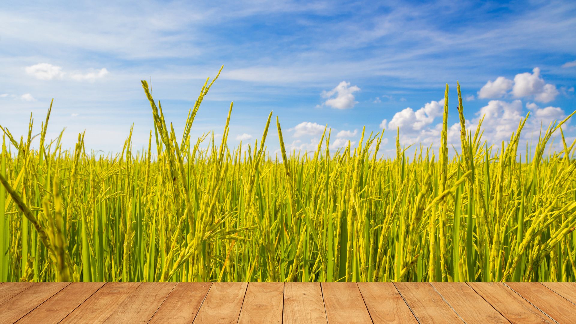
Golden Rice
- 29 May 2024
Why is it in the News?
A court in the Philippines recently revoked biosafety permits for commercial propagation of genetically modified golden rice and Bt eggplant.
What is Golden Rice?
- In the late 1990s, German plant scientists Ingo Potrykus and Peter Beyer developed Golden Rice to combat vitamin A deficiency, a leading cause of infant blindness and increased mortality from infectious diseases like measles.
- Golden Rice is a type of rice that produces beta-carotene, giving it a golden colour, unlike white rice, which lacks these nutrients.
- Vitamin A deficiencies are prevalent in countries where rice is a staple food.
- The widespread use of Golden Rice is expected to improve health by reducing rates of preventable blindness and mortality, especially among children and pregnant women.
Golden Rice and Vitamin A Deficiency:
- Potrykus and Beyer added two genes to white rice in 2004, creating Golden Rice, which they donated to impoverished nations as a solution to vitamin A deficiency (VAD).
- Governments approve Golden Rice cultivation only after ensuring it is safe for the environment, humans, and animals.
- Golden Rice can replace the daily intake of white rice without adverse effects, providing a natural source of vitamin A and beta-carotene to combat VAD.
Efficacy of Golden Rice:
- Adequate vitamin A levels in mothers support vision, immune health, and fetal development through the placenta and breastfeeding.
- Vitamin A deficiency is the leading cause of childhood blindness and weakens the body’s ability to fight common diseases, leading to high mortality rates among young children and their mothers.
- Natural sources of vitamin A include animal products like milk, butter, cheese, eggs, and liver, while plants do not contain vitamin A directly, they contain beta-carotene, which the body can convert into vitamin A.
- White rice is rich in carbohydrates but lacks beta-carotene, an antioxidant and precursor to vitamin A.
- Golden Rice, containing beta-carotene, can help prevent millions of deaths and alleviate suffering from VAD and micronutrient malnutrition in impoverished regions.
Additionally, expanding the cultivation of genetically modified, bio-fortified crops like Golden Rice could further address vitamin deficiencies in developing countries.