El Niño and La Nina

- 23 May 2024
Why is it in the News?
Last month, the India Meteorological Department (IMD) forecasted above-normal rain in the upcoming monsoon season in India, with “favourable” La Nina conditions expected to set in by August-September.
What are El Niño and La Nina?
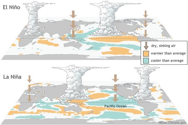
- El Niño (meaning “little boy” in Spanish) and La Nina (meaning “little girl” in Spanish) are climate phenomena that are a result of ocean-atmosphere interactions, which impact the temperature of waters in the central and eastern tropical Pacific Ocean which affects global weather.
- The Earth’s east-west rotation causes all winds blowing between 30 degrees to the north and south of the equator to slant in their trajectory.
- As a result, winds in the region flow towards a southwesterly direction in the northern hemisphere and a northwesterly direction in the southern hemisphere which is known as the Coriolis Effect.
- Due to this, winds in this belt (called trade winds) blow westwards on either side of the equator.
- Under normal ocean conditions, these trade winds travel westwards along the equator from South America towards Asia.
- Wind movement over the ocean results in a phenomenon called upwelling, where cold water beneath the ocean surface rises and displaces the warm surface waters.
- At times, the weak trade winds get pushed back towards South America and there is no upwelling.
- Thus, warmer-than-usual sea surface temperatures are recorded along the equatorial Pacific Ocean, and this is known as the emergence of El Niño conditions.
- Conversely, during La Nina, strong trade winds push warm water towards Asia.
- Greater upwelling gives rise to cold and nutrient-rich water towards South America.
- Thus, climatologically, El Niño and La Nina are opposite phases of what is collectively called the El Niño Southern Oscillation (ENSO) cycle.
- It also includes a third neutral phase.
- El Niño events are far more frequent than La Nina ones.
- Once every two to seven years, neutral ENSO conditions get interrupted by either El Niño or La Nina.
- Recently, La Nina conditions prevailed between 2020 and 2023.
How could the incoming La Nina impact global weather?
- La Niña, driven by the cooling of ocean waters due to the ENSO (El Niño-Southern Oscillation) cycle, can significantly influence global weather patterns.
- The air circulation loop in the region, affected by these temperature changes, impacts precipitation levels in neighbouring areas and can alter the Indian monsoon.
- Currently, the El Niño event that began in June last year has significantly weakened.
- Neutral ENSO conditions are expected to be established by June.
- Following this, La Niña conditions are anticipated to emerge, with its effects likely becoming apparent from August.
La Nina’s Impact on India:
- With above normal rain forecast, the seasonal rainfall is expected to be 106 per cent of the Long Period Average (LPA), which is 880mm (1971-2020 average).
- Except in east and northeast India, all remaining regions are expected to receive normal or above-seasonal rainfall.
- Heavy rains could result in some regions witnessing riverine and urban flooding, mudslides, landslides and cloudbursts.
- East and northeast India region, during La Nina years, receive below average seasonal rainfall.
- Therefore, there may be a shortfall in water reserves there this year.
- During La Nina years, incidents of thunderstorms generally increase.
- “The east and northern India regions could experience thunderstorms accompanied by lightning.
- With increased farming activities undertaken during the July and August rainy months, which coincides with the season’s enhanced lightning and thunderstorms, there is a high risk of fatalities in these regions.
- In addition to ENSO, there are other parameters that can impact the monsoon.
- However, in a La Nina year, a deficit monsoon over India can be easily ruled out.
La Nina’s Impact on the World:
- Similar to India, Indonesia, the Philippines, Malaysia and their neighbouring countries receive good rainfall during a La Nina year.
- This year, Indonesia has already witnessed floods.
- On the other hand, droughts are common in southern regions of North America, where winters become warmer than usual.
- Canada and the northwestern coast of the United States see heavy rainfall and flooding.
- Southern Africa receives higher than usual rainfall, whereas eastern regions of the continent suffer below-average rainfall.
- ENSO has a huge impact on hurricane activity over the Atlantic Ocean.
- During a La Nina year, the hurricane activity here increases.
- For instance, the Atlantic Ocean churned out a record 30 hurricanes during the La Nina year 2021.
Is Climate Change Affecting ENSO?
- Over India, El Niño is known to suppress the southwest monsoon rainfall and drive higher temperatures and intense heat waves, like the present summer season.
- In the past, monsoon seasons during years following an El Niño were 1982-1983 and 1987-1988, with both 1983 and 1988 recording bountiful rainfall.
- At present too, a similar situation could play out.
- The 2020-2023 period witnessed the longest La Nina event of the century.
- Thereafter, ENSO neutral conditions developed, which soon gave way to El Niño by June 2023 which has been weakening since December last year.
- Scientists say that climate change is set to impact the ENSO cycle.
- Many studies suggest that global warming tends to change the mean oceanic conditions over the Pacific Ocean and trigger more El Niño events.
- The World Meteorological Organization (WMO) has also said that climate change is likely to affect the intensity and frequency of extreme weather and climate events linked to El Niño and La Nina.
Indian Ocean Dipole (IOD)

- 08 May 2024
Why is it in the News?
The Positive Indian Ocean Dipole (IOD), also known as the Indian Nino, could potentially resurface for the second consecutive year during the latter part of 2024.
What is the Indian Ocean Dipole (IOD)?
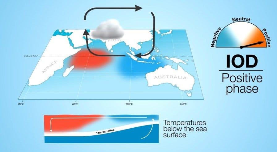
- The Indian Ocean Dipole (IOD) is defined by the difference in the sea surface temperature between the two equatorial areas of the Indian Ocean – a western pole near the Arabian Sea (in western Indian Ocean) and an eastern pole closer to the Bay of Bengal (in eastern Indian Ocean).
- The IOD affects the climate of Southeast Asia, Australia and other countries that surround the Indian Ocean Basin.
- The Indian Monsoon is invariably influenced by the IOD.
- IOD is simply the periodic oscillation of sea surface temperatures, from ‘positive’ to ‘neutral’ and then ‘negative’ phases.
- If the sea surface temperature of the western end rises above normal (0.4°C) and becomes warmer than the eastern end, it leads to a positive IOD.
- This condition is favourable for the Indian Monsoon as it causes a kind of barrier in the eastern Indian Ocean and all the southwesterly winds blow towards the Indian sub-continent.
- Accordingly, the waters in the eastern Indian Ocean cool down, which tends to cause droughts in adjacent land areas of Indonesia and Australia.
- Conversely, during a negative IOD period, the waters of the tropical eastern Indian Ocean are warmer than water in the tropical western Indian Ocean.
- This results in increased rainfall over parts of southern Australia.
Effects on India:
- A positive IOD can boost India's southwest monsoon performance depending on its development timing.
- Example: In 2019, a strong IOD event improved a 30% rainfall deficit during the late monsoon season.
- Benefits for agriculture through recharging water sources and reservoirs.
- The development of IOD likely benefits India's agricultural sector, particularly in areas with precarious water storage levels.
Difference between El Nino and IOD:
- The Indian Ocean Dipole (IOD) and the El Nino are independent climatic phenomena but often co-occur.
- Both IOD and El Nino result in changes in global wind patterns. To know about the change of wind patterns, click here.
- However, the cycle of IOD is shorter, while El Nino condition could last for even two years.
- IOD commences in the month of May and ends with the withdrawal of the Southwest Monsoon in the Indian sub-continent.
