LiDAR (Light Detection and Ranging)

- 01 Nov 2024
In News:
LiDAR (Light Detection and Ranging) is a cutting-edge remote sensing technology that uses laser pulses to measure distances and create detailed 3D maps of Earth's surface. This technology has recently played a crucial role in discovering a lost Mayan city hidden under the dense Mexican jungle.
What is LiDAR?
- Definition: LiDAR is a remote sensing technology that uses pulsed laser light to measure distances and generate precise 3D models of Earth’s surface.
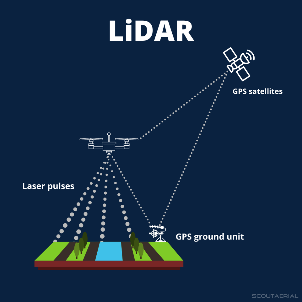
- Components: The system includes a laser, a scanner, and a GPS receiver. It is usually mounted on an aircraft to map large areas of terrain.
- Data Accuracy: LiDAR can create high-resolution 3D models with vertical accuracy up to 10 cm, making it highly precise for mapping ground elevation.
How LiDAR Works
- Laser Emission: LiDAR sends out rapid laser pulses toward the ground.
- Reflection: These pulses hit the Earth’s surface, reflecting off features like vegetation, buildings, and terrain.
- Measurement: The time it takes for the laser light to travel to the ground and back is measured, allowing the system to calculate the distance between the sensor and the surface.
- Point Cloud Data: The reflected light data is collected as a "point cloud", representing all the surfaces it hits, including trees, buildings, and other features.
- Refinement: This point cloud can be processed into a Digital Elevation Model (DEM), stripping away vegetation and structures to reveal the “bare earth,” which highlights features like roads, buildings, and hidden settlements.
Why LiDAR is Useful for Archaeologists
- Large-Scale Surveying: Traditional archaeological methods often involve labor-intensive fieldwork, such as walking over every square meter and manually cutting through thick vegetation. LiDAR, however, allows researchers to quickly survey vast areas of land, even through dense jungle, from the comfort of a lab.
- Visibility Under Vegetation: LiDAR’s ability to penetrate dense foliage and reveal features beneath the surface is a game changer. Even thick tree canopies that obscure the ground are no match for the laser pulses, which can pass through gaps to illuminate hidden structures.
The Discovery of the Lost Mayan City
- The City of Valeriana: Using publicly available LiDAR data from a forest monitoring project in 2013, archaeologist Luke Auld-Thomas discovered a lost Mayan city in Mexico’s Campeche region. The city, named Valeriana, had been hidden for centuries by the thick jungle.
- City Features: The city has all the hallmarks of a Classic Maya political capital, including:
- Multiple enclosed plazas
- Broad causeways
- Temple pyramids
- A ball court
- A reservoir formed by damming a seasonal watercourse
- Historical Significance: Valeriana is believed to date back before 150 CE and may have been a key political and cultural center in the Maya civilization.
Applications of LiDAR Beyond Archaeology
- Geography and Mapping: LiDAR is widely used to generate precise, three-dimensional data about the Earth’s surface, helping geographers and planners.
- Environmental Monitoring: It is also used in forest monitoring, flood risk assessment, and environmental conservation.
- Urban Planning and Engineering: Engineers use LiDAR for creating highly accurate topographical maps and planning infrastructure projects.
