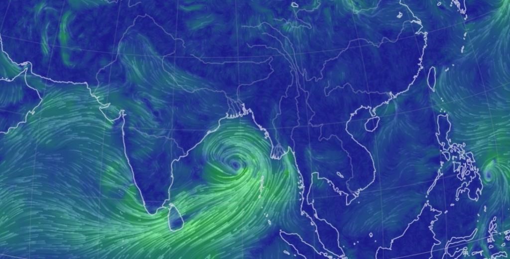
Tropical Cyclone Remal

- 24 May 2024
Why is it in the News?
The first cyclone in the Bay of Bengal this pre-monsoon season, Cyclone Remal, is expected to make landfall between Sagar Island in West Bengal and Bangladesh's Khepupara on Sunday midnight.
About Cyclone Remal:
- The IMD has forecasted that a depression in the Bay of Bengal is likely to concentrate into a severe cyclonic storm and make landfall between Sagar Island in West Bengal and Khepupara in Bangladesh around May 26 midnight.
Name of the cyclone:
- If the cyclone is formed, it will be named 'Remal', which means 'sand' in Arabic.
- The cyclone has been named ‘Remal’, according to a system of naming cyclones in the Indian Ocean region.
- A standard naming convention is followed for tropical cyclones forming in the North Indian Ocean, including the Arabian Sea and the Bay of Bengal.
- As the IMD is a part of the Regional Specialised Meteorological Centres (RSMCs), it gives names to the tropical cyclones after consulting 12 other countries in the region.
- The name 'Remal' has been suggested by Oman which means 'sand' in Arabic.
What is a Tropical Cyclone?
- A tropical cyclone is a rapidly rotating storm system characterized by a low-pressure centre, strong winds, and a spiral arrangement of thunderstorms that produce heavy rain.
- These cyclones develop over warm tropical or subtropical waters and can cause significant damage due to high winds, heavy rainfall, and storm surges.
How a Tropical Cyclone is Formed?
- Tropical cyclones form over warm ocean waters near the equator.
- The process begins when warm, moist air rises from the ocean surface, creating an area of low pressure.
- This causes surrounding air with higher pressure to move toward the low-pressure area, warming up and rising as well.
- As this air rises and cools, the moisture condenses to form clouds.
- The system of clouds and wind starts to spin and grow, fueled by the ocean's heat.
- When the wind speeds increase sufficiently, an eye forms in the centre of the cyclone.
Characteristics of a Tropical Cyclone:
- Calm Center: The eye of the cyclone is calm and clear, with very low air pressure.
- High Wind Speeds: The average wind speed of a tropical cyclone is around 120 km/h.
- Closed Isobars: These are lines on a weather map that connect areas of equal atmospheric pressure, leading to greater wind velocity.
- Oceanic Origin: Tropical cyclones develop over oceans and seas.
- Movement: They typically move from east to west under the influence of trade winds.
- Seasonal: Tropical cyclones are seasonal phenomena.
How are Cyclones Classified?
- The Indian Meteorological Department (IMD) classifies cyclones based on wind speeds:
- Depression: Wind speeds between 31–49 km/h
- Deep Depression: Wind speeds between 50-61 km/h
- Cyclonic Storm: Wind speeds between 62–88 km/h
- Severe Cyclonic Storm: Wind speeds between 89-117 km/h
- Very Severe Cyclonic Storm: Wind speeds between 118-166 km/h
- Extremely Severe Cyclonic Storm: Wind speeds between 166-221 km/h
- Super Cyclonic Storm: Wind speeds above 222 km/h
