NASA Recently Shared a Satellite Image of Deception Island (Tribune India)

- 11 Oct 2023
Why in the News?
National Aeronautics and Space Administration (NASA) recently shared a satellite image of Deception Island, one of the only places in the world where a ship can sail directly into the centre of an active volcano.
About Deception Island:
- Deception Island is situated within the South Shetland Islands, forming part of an archipelago northwest of the Antarctic Peninsula.
- This volcanic island is notable for its dynamic features and distinct geography.
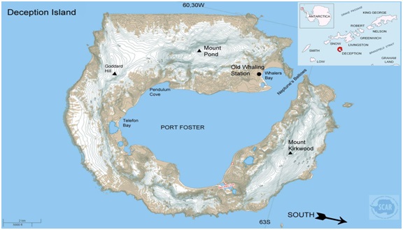
- Originating from a colossal volcanic eruption, Deception Island's formation resulted in the collapse of its central structure, allowing seawater to inundate the resulting caldera.
- The landscape is characterized by desolate volcanic slopes, steaming beaches, and glaciers adorned with ash layers, creating a unique horseshoe-shaped entrance to the sea via Neptune’s Bellows.
- The island encircles Port Foster, recognized as one of the safest harbours in the Antarctic, offering vessels a rare opportunity to navigate into the heart of an active volcano.
- Among the few places globally where this is possible, Deception Island has experienced over twenty eruptions since the 19th century.
- Notably, the island witnessed three volcanic eruptions from 1967 to 1970, leading to the destruction of Chilean and British stations.
- Presently, Argentina and Spain maintain summer scientific stations on the island.
- Deception Island is safeguarded under the Antarctic Treaty, designating it as a protected area with restricted human visits and minimized environmental impact.
