Survey of India (SoI)
- 23 Apr 2024
Why is it in the News?
The Tamil Nadu government filed its objections in the Supreme Court recently, about the Survey of India (SOI) report on the construction of the mega car parking project near the Mullaiperiyar dam, and sought rejection of the report.
What is the Survey of India (SoI)?
- The Survey of India (SoI) serves as the National Survey and Mapping Organization of India, operating under the Department of Science and Technology.
- Established in 1767, it holds the distinction of being the oldest scientific department within the Government of India.
- Tasked with the critical role of being the country's primary mapping agency, SoI bears the responsibility of thoroughly exploring and mapping India's terrain to furnish foundational maps for comprehensive and efficient development initiatives.
- Originally comprising only five directorates in 1950, primarily focused on catering to the mapping requirements of the Defense Forces in the Northwest and Northeast regions, the department has since expanded to encompass 18 directorates spread across the nation, ensuring comprehensive map coverage essential for national development.
- SoI's expertise is widely utilized by various ministries and government undertakings for diverse purposes, including delineating international borders, and state boundaries, and facilitating the planned development of previously underserved areas.
- Moreover, SoI actively contributes to numerous national scientific endeavors in fields such as geophysics, remote sensing, and digital data transmission.
- Functioning as a key advisor to the Government of India on all survey-related matters, including geodesy, photogrammetry, mapping, and map reproduction, SoI fulfills a multitude of duties and responsibilities, which include:
- Conducting all geodetic control, geodetic, and geophysical surveys.
- Undertaking topographical control, surveys, and mapping within India.
- Producing geographical maps and aeronautical charts.
- Conducting surveys for developmental projects.
- Mapping forests, cantonments, large-scale city surveys, guide maps, cadastral surveys, etc.
- Engaging in surveys and mapping for specialized purposes.
- Demarcating India's external boundaries, depicting them on published maps, and advising on inter-state boundary demarcation.
- Conducting research and development in cartography, printing, geodesy, photogrammetry, topographical surveys, and indigenization.
- Predicting tides at 44 ports, including 14 foreign ports, and publishing tide tables one year in advance to support navigational activities.
- Reviewing and certifying India's external boundaries and coastline on maps published by other entities, including private publishers.
- Headquartered: Dehradun (Uttarakhand)
Archaeological Survey of India will ‘Delist’ Some ‘Lost’ Monuments
- 27 Mar 2024
Why is it in the News?
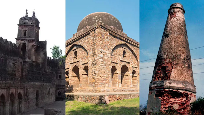
The Archaeological Survey of India (ASI) has decided to delist 18 “centrally protected monuments” because it has assessed that they do not have national importance.
Context:
- ASI has decided to delist 18 protected monuments
- ASI says the monuments have ceased to be of 'national importance'
- The 18 'lost' monuments include eleven in Uttar Pradesh
Significance of Delisting Monuments:
- Several monuments are currently facing the prospect of delisting, including historical landmarks such as a medieval highway milestone in Mujessar village, Barakhamba Cemetery in Delhi, Gunner Burkill’s tomb in Jhansi district, a cemetery at Gaughat in Lucknow, and Telia Nala Buddhist ruins in Varanasi.
- The exact whereabouts or condition of these monuments remain uncertain.
Meaning of Delisting:
- Delisting a monument entails its removal from the roster of protected sites, thereby relinquishing its conservation, protection, and maintenance responsibilities by the Archaeological Survey of India (ASI).
- Under the Ancient Monuments and Archaeological Sites and Remains (AMASR) Act, delisted monuments no longer enjoy protection against construction-related activities in their vicinity, enabling regular urbanization and development activities to proceed uninhibited.
Status of Protected Monuments:
- The inventory of protected monuments is subject to change through additions and removals. Presently, the ASI oversees 3,693 monuments, a number set to decrease to 3,675 following the ongoing delisting initiative.
- This marks the first extensive delisting endeavor in several decades.
Procedures for Monument Delisting:
- The regulations governing the List of Protected Monuments are stipulated under the Ancient Monuments and Archaeological Sites and Remains Rules, 1959.
- This legislation safeguards structures and sites aged over a century, encompassing a diverse array of architectural and historical marvels.
- The government possesses the authority to eliminate certain monuments from the protected list via official notification in the Gazette.
- Through such notifications, the government can declare that certain ancient monuments, archaeological sites, or relics no longer hold national significance under the purview of the AMASR Act (Section 35 of the AMASR Act).
Lost Monuments:
- The Ancient Monuments and Archaeological Sites and Remains (AMASR) Act safeguards monuments and sites aged over a century.
- Nevertheless, numerous structures, particularly smaller or lesser-known ones, have gradually disappeared over time due to factors like urbanization, encroachments, dam and reservoir construction, or neglect.
- In some instances, the lack of public memory hampers efforts to locate these monuments.
Extent of Loss:
- According to a submission by the Ministry of Culture to the Parliamentary Standing Committee on Transport, Tourism, and Culture in December 2022, 50 out of India's 3,693 centrally protected monuments were unaccounted for.
- Among these, 14 succumbed to rapid urbanization, 12 were submerged by reservoirs or dams, and the remaining 24 remain untraceable.
- The Committee noted that budget constraints limited the provision of security guards to historical sites, with only 2,578 guards assigned to 248 sites out of the required 7,000.
- Additionally, a 2013 report by the Comptroller and Auditor General (CAG) of India highlighted the disappearance of at least 92 centrally protected monuments nationwide.
About the Archaeological Survey of India (ASI):
- Founded in 1861 by Alexander Cunningham, the Archaeological Survey of India (ASI) was later formalized as a statutory body under the Ancient Monuments and Archaeological Sites and Remains Act, 1958 (AMASR Act) following India's independence.
- ASI's primary mandate encompasses archaeological research and the safeguarding, conservation, and preservation of cultural monuments across the nation.
- Its operational scope includes conducting surveys of antiquarian remains, exploring and excavating archaeological sites, and overseeing the conservation and maintenance of protected monuments, among other responsibilities.
- The ASI operates under the purview of the Ministry of Culture.
Pandavula Gutta designated an exclusive Geo-heritage site in Telangana
- 16 Mar 2024
Why is it in the News?
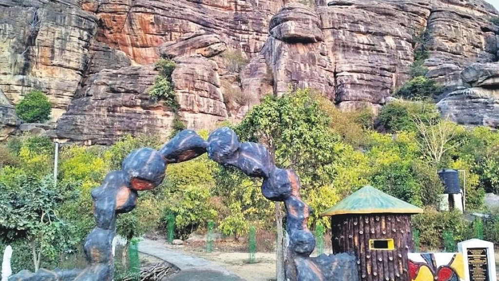
Pandavula Gutta, a geological marvel older than the Himalayan hills, has been officially recognized as the sole Geo-heritage site in Telangana.
What is Pandavula Gutta?
- Pandavula Gutta holds historical significance, being older than the Himalayas and renowned for its ancient rock paintings portraying diverse animals such as bison, antelope, tiger, and leopard, along with intricate geometric designs and symbols like swastikas, circles, and squares.
- These paintings indicate continuous human habitation from the Mesolithic period (around 12,000 to 6,000 BCE) through medieval times.
About Geo-heritage Sites:
- Geo-heritage sites encompass geological features of inherent or cultural significance, providing insights into the Earth's evolution or history, valuable for earth science and educational purposes.
- In India, the Geological Survey of India (GSI) identifies and designates these special places as Geo-Heritage Sites (GHS) to ensure their preservation, akin to UNESCO's protection of world heritage sites worldwide.
About the Geological Survey of India (GSI):
- The Geological Survey of India (GSI), established in 1851 initially to locate coal deposits for the Railways, has evolved into a comprehensive repository of geo-science information vital for various sectors in India.
- Its objective is to provide impartial and current geological expertise and geoscientific data to inform policy-making decisions and address commercial and socio-economic needs.
- Designated as the primary agency for geological mapping and regional mineral resources assessment under the National Mineral Policy (NMP) 2008, GSI emphasizes systematic documentation of geological processes across India and its offshore areas.
- Utilizing advanced techniques and methodologies, including geological, geophysical, and geochemical surveys, the organization operates from its headquarters in Kolkata, along with six regional offices and state units across the country.
- Presently, GSI operates as an attached office to the Ministry of Mines.