Dark Comets
- 20 Dec 2024
In News:
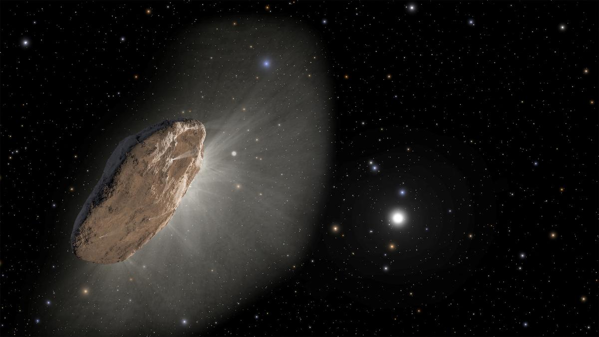
Dark comets are a newly identified class of celestial objects that challenge our traditional understanding of comets and asteroids. Unlike regular comets, these objects exhibit characteristics that blur the lines between comets and asteroids, leading astronomers to closely study their nature, origin, and significance.
Discovery and Background
The first hint of dark comets appeared in 2016, when asteroid 2003 RM exhibited strange orbital deviations that suggested it might be a comet in disguise. NASA further fueled this interest in 2017 when it discovered ‘Oumuamua, an interstellar object that entered our Solar System. Though initially classified as an asteroid, its erratic motion and lack of a visible tail led scientists to consider it a dark comet. Since then, several more objects with similar characteristics have been discovered, and astronomers now identify these objects as a new class—dark comets.
Characteristics of Dark Comets
- Appearance: Dark comets do not exhibit the brilliant, glowing tails typically associated with comets. Instead, they resemble asteroids, appearing as faint points of light in space. Unlike bright comets, they do not have a visible coma (a cloud of gas and dust) or a tail, making them much harder to detect.
- Size: Dark comets are typically small, ranging from a few meters to a few hundred meters in diameter. Due to their small size, there is less surface area for material to escape, preventing the formation of the iconic tails seen in traditional comets.
- Orbital Path: These objects follow elongated, elliptical orbits. While some of them travel close to the Sun, they can also venture to the outer reaches of the Solar System, far beyond Pluto, and even into the Oort Cloud—the distant region where long-period comets are believed to originate.
- Spin and Gas Dispersion: Dark comets often rotate rapidly, dispersing gas and dust in all directions. This rapid spin contributes to their invisibility, as the gas and dust are scattered evenly, making it more difficult for astronomers to detect their presence.
- Composition: The composition of dark comets may also play a role in their lack of visibility. Over time, the materials that form the bright tails of comets may be depleted, especially for older objects. As a result, dark comets may not release enough gas to produce a visible coma or tail.
Types of Dark Comets
There are two main categories of dark comets:
- Inner Dark Comets: These are smaller objects that reside closer to the Sun and typically travel in nearly circular orbits. They are often just a few meters in size, with less surface area for gas and dust to escape.
- Outer Dark Comets: These larger objects, measuring over 100 meters in diameter, travel in highly eccentric orbits, similar to Jupiter-family comets. These dark comets follow elliptical paths that bring them close to the Sun and then send them back toward the outer reaches of the Solar System.
Importance of Studying Dark Comets
Dark comets may hold critical clues about the early Solar System and the formation of Earth. Studying these objects can provide insights into the origins of water on Earth, as well as the ingredients necessary for life. Their unique composition and orbits also offer potential for understanding the processes that led to the formation of planets.
Recent Discoveries and Advancements
Astronomers recently discovered 10 new dark comets with the help of the Dark Energy Camera (DECam) on a large telescope in Chile. The DECam, designed to study distant galaxies and stars, has enabled researchers to detect these faint objects by analyzing images of the night sky. Further progress is expected with the upcoming Vera C. Rubin Observatory, which will feature the largest digital camera ever built. This new instrument will allow astronomers to capture more detailed images of the night sky and detect fainter objects, potentially doubling or even tripling the number of known dark comets in the next decade.
Key Facts:
- Dark comets lack the characteristic glowing tails of typical comets, instead resembling asteroids.
- They exhibit erratic motions and follow elliptical orbits, often extending beyond Pluto and into the Oort Cloud.
- They are typically small (a few meters to hundreds of meters wide) and spin rapidly.
- The first dark comet was identified in 2016, with more discoveries made in the years since.
- The Dark Energy Camera (DECam) in Chile has been instrumental in detecting these elusive objects, with a new Vera C. Rubin Observatory expected to further enhance detection in the future.
- Studies suggest that between 0.5% and 60% of Near-Earth Objects (NEOs) could be dark comets, many originating from the asteroid belt between Mars and Jupiter.
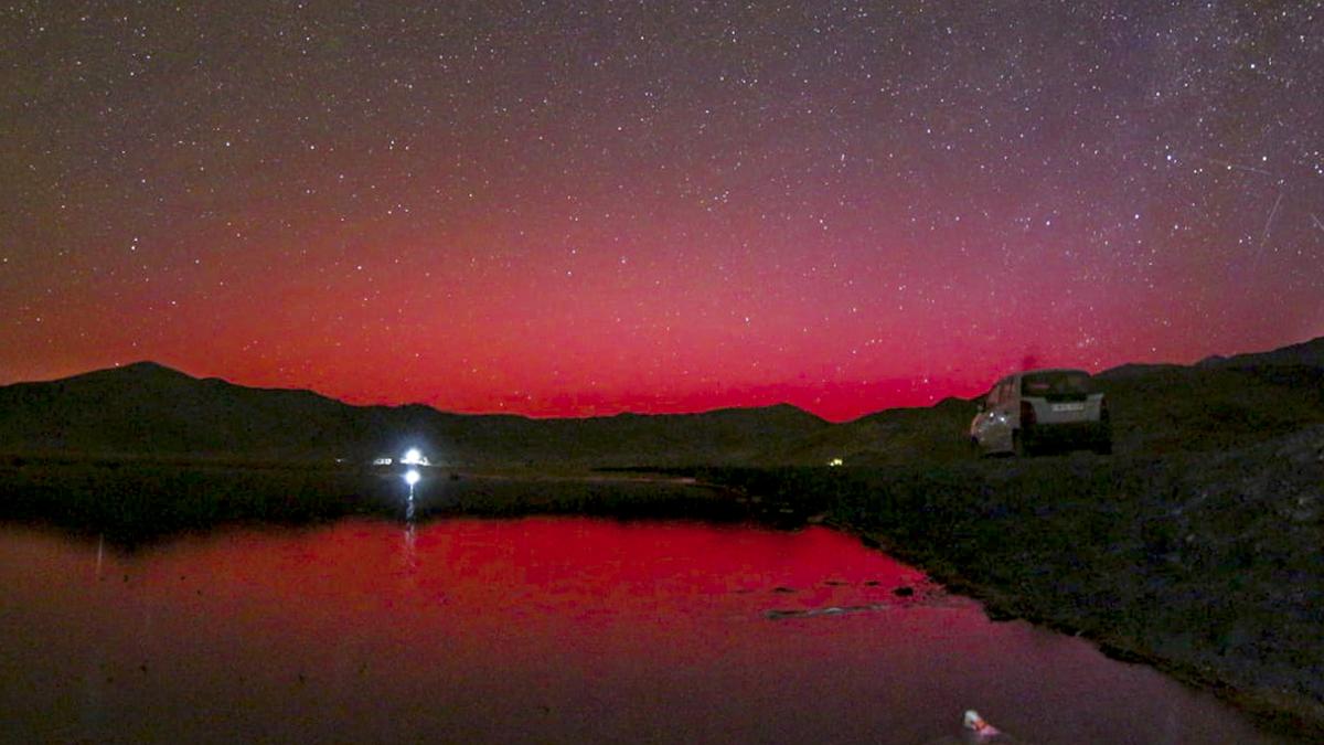
Ladakh's Aurorae
- 14 Oct 2024
In News:
In October 2024, Ladakh witnessed spectacular auroras, typically seen in higher latitudes, indicating increased solar activity. This phenomenon was reported following intense solar storms, with red and green lights observed in the night sky. The auroras were captured by all-sky cameras operated by the Indian Institute of Astrophysics (IIA) in Hanle and Merak.
What Are Auroras?
Auroras are vibrant displays of light caused by interactions between charged particles from the Sun and Earth's magnetosphere. When solar winds—streams of charged particles—collide with atoms in the upper atmosphere, they create visible light, similar to how neon lights function.
Causes of Recent Auroras
The recent auroras in Ladakh were linked to several strong solar storms, particularly coronal mass ejections (CMEs), which are significant bursts of solar wind and magnetic fields rising above the solar corona. The storms, emanating from active solar regions, traveled towards Earth at remarkable speeds, disrupting the normal space weather and allowing auroras to be visible at lower latitudes, including Mexico and Germany.
Implications of Solar Activity
Astrophysicists at the Center of Excellence in Space Sciences India (CESSI) noted that these auroras validate ongoing efforts in space weather monitoring. The increased solar activity is part of the solar cycle, which peaks approximately every 11 years. Current predictions indicate that Solar Cycle 25 may reach its peak in 2024.
Monitoring Space Weather
Organizations like the National Oceanic and Atmospheric Administration (NOAA) closely monitor space weather to provide timely warnings about solar events that could disrupt satellite communications and other services. The CESSI team successfully predicted the occurrence of solar storms, enhancing confidence in their ability to forecast space weather and its potential impacts.
Potential Hazards
While auroras are visually striking, intense solar storms can have detrimental effects, including:
- Satellite Disruption: Increased drag and radiation can damage satellites in low Earth orbit, affecting navigation, communications, and military operations.
- Communication Blackouts: Severe storms can interfere with radio and satellite communications, impacting daily life and services.
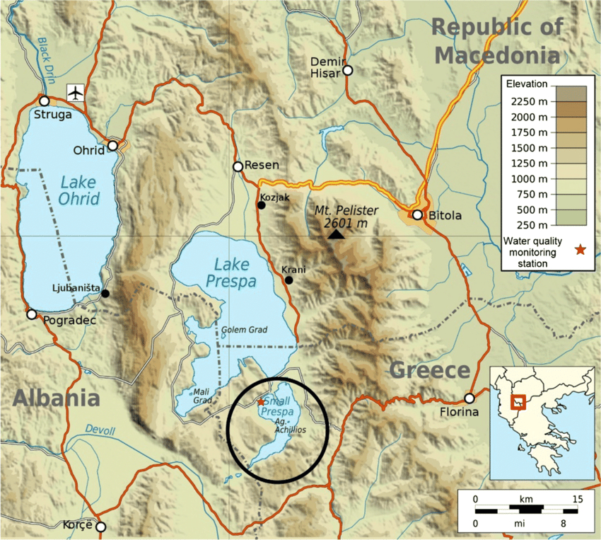
Little Prespa Lake's Decline
- 03 Oct 2024
In News:
Little Prespa Lake on Albanian-Greek border slowly dying.
Overview of Little Prespa Lake's Decline
- Location and Geography:
- Little Prespa Lake is situated on the Albanian-Greek border, primarily in Greece with a southern tip extending into Albania.
- It covers approximately 450 hectares in Albania, now largely transformed into swamps or dry land.
- Ecological Changes:
- Once a crystal-clear lake, it has degraded into a marshy area, with about 430 hectares in Albania suffering from significant drying.
- Local wildlife has shifted; cows now roam where fish once thrived.
- Historical Context:
- The lake's decline began in the 1970s when Albanian authorities diverted the Devoll River to irrigate surrounding agricultural lands, severely limiting water inflow.
- Climate Change Impact:
- Rising temperatures, mild winters, and decreased precipitation have intensified the lake’s ecological crisis.
- Local experts warn that continued dry winters and hot summers could lead to irreversible damage.
La Nina and North India’s pollution
- 01 Oct 2024
In News:
Recent research by scientists at the National Institute of Advanced Science (NIAS) has underlined the links between climate change, La Niña and air quality.
Key Points on Air Quality Outlook for Delhi and North India
- Delayed La Niña & Monsoon Retreat:
- Erosion of optimism for improved air quality this winter in Delhi.
- Significant pollution challenges anticipated in early winter months.
- Possible relief in December and January, contingent on La Niña strengthening.
- Impact of Stubble Burning:
- If stubble burning occurs at half the intensity of previous years, November air quality may deteriorate.
- Research Insights:
- Study by National Institute of Advanced Science (NIAS) links climate change, La Niña, and air quality.
- Notable air quality improvement in winter 2022-23 was linked to La Niña conditions.
- Late onset of La Niña contributes to air quality uncertainty.
- Changing Pollution Dynamics:
- Shift from local emission-centric views to broader climatological factors is necessary.
- Air quality in Delhi worsens during winter due to high humidity, calm winds, and poor pollutant dispersion.
- La Niña Delays:
- Delayed La Niña onset means weak winds and stagnant conditions, worsening pollution.
- Expected development between September and November 2024.
- Effects of Stubble Burning:
- North-north-westerly winds could carry pollution from stubble burning in Punjab and Haryana into Delhi.
- Potential Outcomes of Late La Niña Onset:
- If La Niña develops in December or January, may improve air quality slightly.
- However, a longer, severe winter could exacerbate pollution issues due to lower inversion layers.
- NIAS-SAFAR Model Predictions:
- Early La Niña could have worsened air quality in the peninsular region.
- Early onset might have improved northern air quality.
- Link to Climate Change:
- Evidence suggests extreme air pollution correlates with climate change.
- Emphasizes the need for rigorous mitigation efforts and broader airshed management.
- Call for Rethinking Air Quality Strategies:
- Focus on integrating larger climatic factors into air quality policies.
- Prioritize health-centric measures through collaborative efforts with scientific bodies.
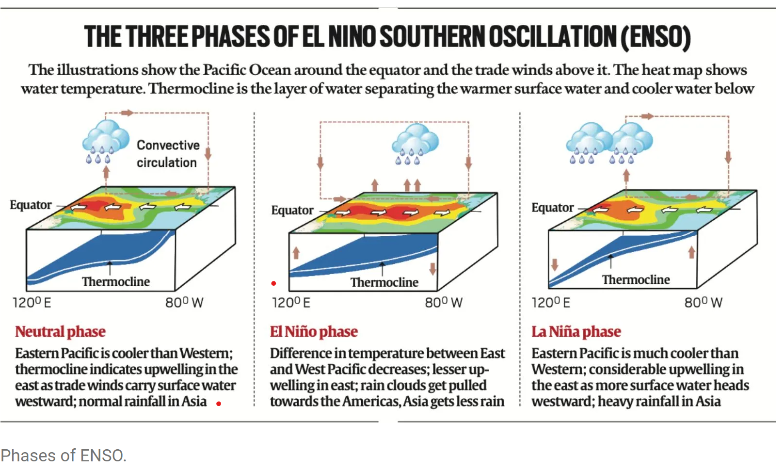
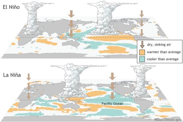
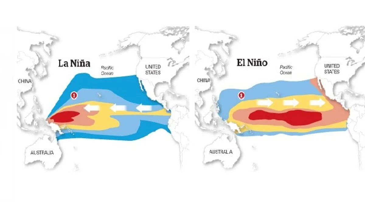
What is La Niña?
- La Niña (or ‘The Little Girl’ in Spanish) is a phase of what climatologists refer to as the El Niño Southern Oscillation (ENSO), a phenomenon that is a key driver of global natural climate variability.
- ENSO is characterised by changes in sea temperatures along the tropical Pacific Ocean due to atmospheric fluctuations overhead. These changes alter and interfere with the global atmospheric circulation, and influence weather worldwide.
- Occurring in irregular cycles of anywhere between two to seven years, ENSO has three phases — warm (El Niño or ‘The Little Boy’ in Spanish), cool (La Niña), and neutral.
- During the neutral phase, the eastern Pacific (off the northwestern coast of South America) is cooler than the western Pacific (around Philippines and Indonesia). This is because prevailing trade winds — caused by Earth’s rotation, between 30 degrees north and south of the equator — move east to west, sweeping warmer surface water along with them. The relatively cool waters from below rise to the surface to replace the displaced water.
- These wind systems weaken in the El Niño phase, leading to lesser displacement of warmer waters off the American coasts. Consequently, the eastern Pacific becomes warmer than usual. The opposite happens in the La Niña phase i.e. trade winds become stronger than usual and push larger quantities of water to the western Pacific.
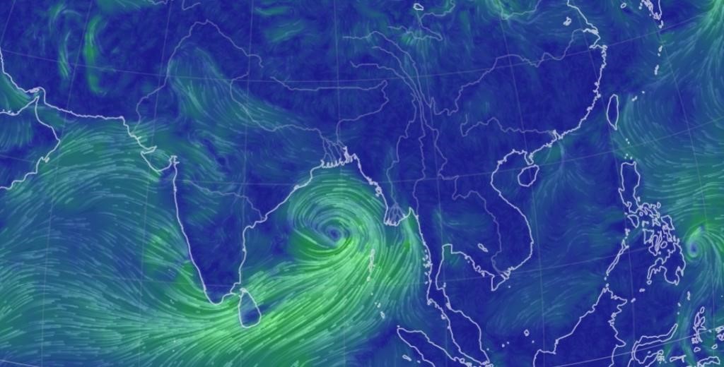
Uncommon Cyclones in the Arabian Sea
- 09 Sep 2024
Cyclones are intense weather systems with low atmospheric pressure and rotating winds, forming over warm tropical waters. These storms cause severe weather, including heavy rainfall, strong winds, and storm surges. Cyclones are categorized based on wind speeds, from tropical depressions to severe cyclonic storms. Warm ocean surfaces and high humidity fuel these storms, with atmospheric conditions like wind shear and moisture influencing their strength and formation.
The North Indian Ocean plays a key role in global weather systems, particularly the summer monsoon. Warm waters from the Arabian Sea and Bay of Bengal are crucial for moisture generation during monsoon seasons. However, despite the warm ocean surfaces that typically promote cyclones, this region has fewer cyclones compared to other tropical oceans. A mix of factors—both promoting and suppressing cyclone formation—makes the North Indian Ocean a unique and less cyclone-prone area.
The Indian Ocean stands out due to its monsoonal circulation, marked by seasonal wind reversals north of the equator. It also has "oceanic tunnels" connecting it to the Pacific and Southern Oceans, which influence its weather. The Pacific tunnel introduces warm water into the upper layers, while the Southern Ocean brings cooler waters into deeper levels. These oceanographic features contribute to distinct weather patterns, including influencing the formation and behavior of cyclones.
As the pre-monsoon season begins and the Sun moves into the northern hemisphere, the Arabian Sea rapidly warms. The Bay of Bengal, typically warmer, heats further, driving atmospheric convection and rainfall. These warming patterns make the Bay of Bengal more prone to cyclones, while the Arabian Sea, with its cooler waters and stronger wind shear, experiences less cyclone activity. These conditions contribute to significant differences in cyclone formation between the two seas.
Impact of Climate Change on Cyclones in the Indian Ocean
Climate change is amplifying the Indian Ocean’s warming, bringing in more heat from the Pacific Ocean while the Southern Ocean pushes warmer waters into deeper layers. These changes, combined with shifts in winds and atmospheric humidity, are causing the Indian Ocean to warm at a rapid pace. This warming is affecting cyclone formation, increasing the frequency and intensity of storms. The Indian Ocean acts as a "clearinghouse" for ocean warming, impacting global weather patterns and intensifying cyclone activity.
Monsoon and Cyclone Seasons in the North Indian Ocean
- The monsoon heavily influences cyclone activity in the region. During the monsoon, strong winds cool the Arabian Sea, reducing the likelihood of cyclone formation. In contrast, the Bay of Bengal sees more low-pressure systems, although many do not become cyclones due to wind shear that weakens their energy.
- The North Indian Ocean experiences two distinct cyclone seasons—pre-monsoon and post-monsoon—unlike other regions that typically have just one. Cooler temperatures and stronger wind shear keep cyclone numbers low in the Arabian Sea, compared to the Bay of Bengal.
- Cyclone Asna, formed in August 2023, was a rare cyclone for this time of year. It developed from a land-based depression that moved over the Arabian Sea, marking the first August cyclone in the region since 1981. This rare occurrence highlights how rapidly warming oceans, influenced by climate change and El Niño, can drive unexpected cyclone formations.
Tropical Cyclone Remal
- 24 May 2024
Why is it in the News?
The first cyclone in the Bay of Bengal this pre-monsoon season, Cyclone Remal, is expected to make landfall between Sagar Island in West Bengal and Bangladesh's Khepupara on Sunday midnight.
About Cyclone Remal:
- The IMD has forecasted that a depression in the Bay of Bengal is likely to concentrate into a severe cyclonic storm and make landfall between Sagar Island in West Bengal and Khepupara in Bangladesh around May 26 midnight.
Name of the cyclone:
- If the cyclone is formed, it will be named 'Remal', which means 'sand' in Arabic.
- The cyclone has been named ‘Remal’, according to a system of naming cyclones in the Indian Ocean region.
- A standard naming convention is followed for tropical cyclones forming in the North Indian Ocean, including the Arabian Sea and the Bay of Bengal.
- As the IMD is a part of the Regional Specialised Meteorological Centres (RSMCs), it gives names to the tropical cyclones after consulting 12 other countries in the region.
- The name 'Remal' has been suggested by Oman which means 'sand' in Arabic.
What is a Tropical Cyclone?
- A tropical cyclone is a rapidly rotating storm system characterized by a low-pressure centre, strong winds, and a spiral arrangement of thunderstorms that produce heavy rain.
- These cyclones develop over warm tropical or subtropical waters and can cause significant damage due to high winds, heavy rainfall, and storm surges.
How a Tropical Cyclone is Formed?
- Tropical cyclones form over warm ocean waters near the equator.
- The process begins when warm, moist air rises from the ocean surface, creating an area of low pressure.
- This causes surrounding air with higher pressure to move toward the low-pressure area, warming up and rising as well.
- As this air rises and cools, the moisture condenses to form clouds.
- The system of clouds and wind starts to spin and grow, fueled by the ocean's heat.
- When the wind speeds increase sufficiently, an eye forms in the centre of the cyclone.
Characteristics of a Tropical Cyclone:
- Calm Center: The eye of the cyclone is calm and clear, with very low air pressure.
- High Wind Speeds: The average wind speed of a tropical cyclone is around 120 km/h.
- Closed Isobars: These are lines on a weather map that connect areas of equal atmospheric pressure, leading to greater wind velocity.
- Oceanic Origin: Tropical cyclones develop over oceans and seas.
- Movement: They typically move from east to west under the influence of trade winds.
- Seasonal: Tropical cyclones are seasonal phenomena.
How are Cyclones Classified?
- The Indian Meteorological Department (IMD) classifies cyclones based on wind speeds:
- Depression: Wind speeds between 31–49 km/h
- Deep Depression: Wind speeds between 50-61 km/h
- Cyclonic Storm: Wind speeds between 62–88 km/h
- Severe Cyclonic Storm: Wind speeds between 89-117 km/h
- Very Severe Cyclonic Storm: Wind speeds between 118-166 km/h
- Extremely Severe Cyclonic Storm: Wind speeds between 166-221 km/h
- Super Cyclonic Storm: Wind speeds above 222 km/h
El Niño and La Nina
- 23 May 2024
Why is it in the News?
Last month, the India Meteorological Department (IMD) forecasted above-normal rain in the upcoming monsoon season in India, with “favourable” La Nina conditions expected to set in by August-September.
What are El Niño and La Nina?
- El Niño (meaning “little boy” in Spanish) and La Nina (meaning “little girl” in Spanish) are climate phenomena that are a result of ocean-atmosphere interactions, which impact the temperature of waters in the central and eastern tropical Pacific Ocean which affects global weather.
- The Earth’s east-west rotation causes all winds blowing between 30 degrees to the north and south of the equator to slant in their trajectory.
- As a result, winds in the region flow towards a southwesterly direction in the northern hemisphere and a northwesterly direction in the southern hemisphere which is known as the Coriolis Effect.
- Due to this, winds in this belt (called trade winds) blow westwards on either side of the equator.
- Under normal ocean conditions, these trade winds travel westwards along the equator from South America towards Asia.
- Wind movement over the ocean results in a phenomenon called upwelling, where cold water beneath the ocean surface rises and displaces the warm surface waters.
- At times, the weak trade winds get pushed back towards South America and there is no upwelling.
- Thus, warmer-than-usual sea surface temperatures are recorded along the equatorial Pacific Ocean, and this is known as the emergence of El Niño conditions.
- Conversely, during La Nina, strong trade winds push warm water towards Asia.
- Greater upwelling gives rise to cold and nutrient-rich water towards South America.
- Thus, climatologically, El Niño and La Nina are opposite phases of what is collectively called the El Niño Southern Oscillation (ENSO) cycle.
- It also includes a third neutral phase.
- El Niño events are far more frequent than La Nina ones.
- Once every two to seven years, neutral ENSO conditions get interrupted by either El Niño or La Nina.
- Recently, La Nina conditions prevailed between 2020 and 2023.
How could the incoming La Nina impact global weather?
- La Niña, driven by the cooling of ocean waters due to the ENSO (El Niño-Southern Oscillation) cycle, can significantly influence global weather patterns.
- The air circulation loop in the region, affected by these temperature changes, impacts precipitation levels in neighbouring areas and can alter the Indian monsoon.
- Currently, the El Niño event that began in June last year has significantly weakened.
- Neutral ENSO conditions are expected to be established by June.
- Following this, La Niña conditions are anticipated to emerge, with its effects likely becoming apparent from August.
La Nina’s Impact on India:
- With above normal rain forecast, the seasonal rainfall is expected to be 106 per cent of the Long Period Average (LPA), which is 880mm (1971-2020 average).
- Except in east and northeast India, all remaining regions are expected to receive normal or above-seasonal rainfall.
- Heavy rains could result in some regions witnessing riverine and urban flooding, mudslides, landslides and cloudbursts.
- East and northeast India region, during La Nina years, receive below average seasonal rainfall.
- Therefore, there may be a shortfall in water reserves there this year.
- During La Nina years, incidents of thunderstorms generally increase.
- “The east and northern India regions could experience thunderstorms accompanied by lightning.
- With increased farming activities undertaken during the July and August rainy months, which coincides with the season’s enhanced lightning and thunderstorms, there is a high risk of fatalities in these regions.
- In addition to ENSO, there are other parameters that can impact the monsoon.
- However, in a La Nina year, a deficit monsoon over India can be easily ruled out.
La Nina’s Impact on the World:
- Similar to India, Indonesia, the Philippines, Malaysia and their neighbouring countries receive good rainfall during a La Nina year.
- This year, Indonesia has already witnessed floods.
- On the other hand, droughts are common in southern regions of North America, where winters become warmer than usual.
- Canada and the northwestern coast of the United States see heavy rainfall and flooding.
- Southern Africa receives higher than usual rainfall, whereas eastern regions of the continent suffer below-average rainfall.
- ENSO has a huge impact on hurricane activity over the Atlantic Ocean.
- During a La Nina year, the hurricane activity here increases.
- For instance, the Atlantic Ocean churned out a record 30 hurricanes during the La Nina year 2021.
Is Climate Change Affecting ENSO?
- Over India, El Niño is known to suppress the southwest monsoon rainfall and drive higher temperatures and intense heat waves, like the present summer season.
- In the past, monsoon seasons during years following an El Niño were 1982-1983 and 1987-1988, with both 1983 and 1988 recording bountiful rainfall.
- At present too, a similar situation could play out.
- The 2020-2023 period witnessed the longest La Nina event of the century.
- Thereafter, ENSO neutral conditions developed, which soon gave way to El Niño by June 2023 which has been weakening since December last year.
- Scientists say that climate change is set to impact the ENSO cycle.
- Many studies suggest that global warming tends to change the mean oceanic conditions over the Pacific Ocean and trigger more El Niño events.
- The World Meteorological Organization (WMO) has also said that climate change is likely to affect the intensity and frequency of extreme weather and climate events linked to El Niño and La Nina.
Oceanic Niño Index (ONI)
- 08 Apr 2024
Why is it in the News?
The US National Oceanic and Atmospheric Administration (NOAA) has recently forecasted an 83% likelihood that the Oceanic Niño Index (ONI) will move into a neutral range between April and June 2024.
What is the Oceanic Niño Index?
- The Oceanic Niño Index (ONI) is the National Oceanic and Atmospheric Administration's (NOAA) primary indicator for monitoring El Niño and La Niña, which are opposite phases of the climate pattern called the El Niño-Southern Oscillation, or “ENSO” for short.
- NOAA is a US governmental agency responsible for monitoring and researching the Earth's oceans, atmosphere, and climate, and providing weather forecasts and environmental data.
- The ONI is the difference between a three-month running average of the sea surface temperature averaged over an area of the ocean from 120 West to 170 West longitude along the equator and the long-term average for the same three months.
- NOAA considers El Niño conditions to be present when the Oceanic Niño Index is +0.5 or higher, indicating the east-central tropical Pacific is significantly warmer than usual.
- La Niña conditions exist when the Oceanic Niño Index is -0.5 or lower, indicating the region is cooler than usual.
What is El Niño and La Niña?
- El Niño and La Niña are two natural climate phenomena that occur in the Pacific Ocean, characterized by fluctuations in ocean surface temperatures.
- They are part of the El Niño-Southern Oscillation (ENSO) cycle, which impacts global weather patterns.
- El Niño refers to the warming of ocean surface temperatures in the eastern tropical Pacific.
- This warming causes changes in atmospheric pressure and wind patterns, which can lead to drought conditions in parts of South America and heavy rainfall in other regions, such as the southern United States.
- La Niña is the opposite phase of the ENSO cycle, characterized by cooler-than-average ocean surface temperatures in the eastern tropical Pacific.
- This results in the strengthening of normal trade winds, causing increased rainfall in some regions, such as Indonesia and northern Australia, and drier conditions in other areas, including the southwestern United States.
- El Niño refers to the warming of ocean surface temperatures in the eastern tropical Pacific.
Effects of El Niño and La Niña on India:
- Both El Niño and La Niña have significant impacts on India's climate, particularly during the monsoon season.
- El Niño events often lead to weaker monsoon winds and reduced rainfall in India, causing droughts and impacting agricultural production.
- On the other hand, La Niña events typically result in stronger monsoon winds and higher rainfall, leading to better agricultural yields.
- However, excessive rainfall can also cause floods and landslides in some regions.
- Monitoring and predicting the occurrence of El Niño and La Niña events is crucial for India's weather forecasting and agricultural planning.
- Accurate predictions enable authorities to take necessary measures to mitigate potential adverse effects on agriculture and infrastructure.
Earth’s early evolution: Fresh insights from rocks formed 3.5 billion years ago
- 23 Feb 2024
Why is it in the News?
Exploring ancient cratons such as the Singhbhum Craton in India, alongside similar formations in South Africa and Australia, provides unparalleled insights into the early stages of our planet's development, reaching back approximately 3.5 billion years.
What is Singhbhum Craton?
- The Singhbhum Craton encompasses a vast expanse of rugged terrain, primarily spanning regions in Jharkhand and Odisha, situated between the Chhota Nagpur plateau and the Eastern Ghats.
- Dating back approximately 3.5 billion years, this ancient segment of the Earth's crust offers valuable insights into early geological processes.
- Its oldest rock formations consist predominantly of volcanic and sedimentary rocks, referred to as greenstone successions.
- Greenstones are characterised by submarine volcanic rocks with minor sedimentary components.
- Geologically akin to greenstone belts in South Africa's Barberton and Nondweni regions and the Pilbara Craton in Western Australia, these areas experienced extensive submarine mafic volcanic activity, rich in magnesium oxide, between 3.5 and 3.3 billion years ago, with preserved features like pillowed lava and komatiites.
Significance:
- The Singhbhum Craton sheds light on early tectonic activities during the Archaean era, enhancing our understanding of the Earth's formative stages.
- Its distinctive geological characteristics, particularly the presence of greenstone belts, yield invaluable data on surface and atmospheric processes crucial for theorising about early habitable conditions and the emergence of life on Earth.
What are Cratons?
- A craton is a stable and ancient part of Earth's lithosphere that has experienced long-term tectonic and geomorphic stability.
- It is considered to be the nucleus of a continent and is characterised by its thick and cold lithosphere.
- Cratons can undergo destruction, which is defined as a geological process resulting in the loss of craton stability due to changes in its physical and chemical properties.
- The mechanisms responsible for craton destruction include oceanic plate subduction, rollback and retreat of subducting plates, stagnation and dehydration of subducting plates in the mantle transition zone, melting of the mantle caused by dehydration of stagnant slabs, non-steady flow in the upper mantle induced by melting, and changes like the lithospheric mantle.
- Craton destruction can lead to crustal thinning, surface uplift, and the concentration of mineral deposits.