NISAR Satellite Can Monitor Earth’s Tectonic Movements
- 15 May 2024
Why is it in the News?
ISRO Chairman S. Somanath recently announced that the NISAR satellite has the capability to accurately monitor tectonic movements and complete full mappings of the Earth twice a month.
About the NISAR Satellite:
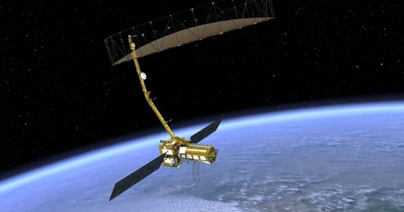
- NISAR is a joint Earth-observing mission between NASA and the Indian Space Research Organization (ISRO).
- It is a Synthetic Aperture Radar satellite with two bands.
- It will be launched into a polar Sun-synchronous dawn-dusk orbit.
- One is the S-band and the other is the L-band.
- The S-band payload has been made by the ISRO and the L-band payload by the U.S.
- The U.S. will contribute to the large deployable antenna.
- This being a dual-band polarizable radar, it can do a lot of things.
- First, because it has a large deployable antenna with an 18-metre diameter, it has a very high swath.
- It can fully cover the earth in approximately 14 to 15 days, according to radar.
- It can monitor various aspects in very high resolution.
- For example, it can monitor the tectonic movements to centimetre accuracy.
- It can do measurements of water bodies accurately.
- It can look at water stressing on the earth, wherever there is a deficiency of water.
- It can ground-penetrate to a certain depth.
- It is capable of monitoring the vegetation cover and snow cover.
- It, therefore, basically looks at the whole of the earth in terms of surface, water, greenery and all of that.
- It measures accurately and gives repetitive, full coverage of the earth two times a month.
- It means it is capable of a lot of observation and this data will be available to both India and the U.S.
- We can study the water-stressing, climate change-related issues, and agricultural changes through patterns, yield, desertification and continental movements precisely with respect to annual water cycle movements.
- It can measure tectonic plate movements accurately.
- So a lot of geological, agricultural and water-related observations can be obtained from this satellite.
Mission Objectives:
- The primary goal of NISAR is to provide precise measurements of tectonic plate movements, enabling comprehensive observations in geology, agriculture, and water-related domains.
- Additionally, it aims to analyze water stress, climate change impacts, agricultural shifts, desertification, and continental shifts with accuracy, particularly concerning annual water cycle variations.
- NISAR's data will facilitate global resource and hazard management, while also aiding scientists in comprehending climate change dynamics and its effects.
Launch Schedule:
- Initially planned for July, the launch is now expected in October-November due to issues on the U.S. side requiring corrections.