Bathymetry
- 26 Apr 2024
Why is it in the News?
Scientists from the Indian National Centre for Ocean Information Services (INCOIS) recently conducted a study of the bathymetry, or ocean floor, in the Indian Ocean.
What is Bathymetry?
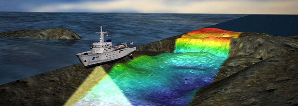
- Bathymetry is a technique dedicated to mapping the depths of water bodies, that is, it is the measurement and representation of the topography of the bottom of rivers, seas, and oceans.
- In addition to measuring depth, this study also includes identifying underwater relief and creating three-dimensional maps of the sea floor.
- The word “bathymetry” comes from the Greek "bathýs", meaning deep, and "metron", meaning measure.
- Bathymetry allows for obtaining information about the physical characteristics of the sea floor, such as seamounts, mountain ranges, valleys, abyssal plains, and underwater canyons.
How is Bathymetry Performed?
- To carry out bathymetry, specific equipment is used, such as multibeam sonar (MultiBeam Echosounder), IMU (Inertial Measurement Unit), and high-precision positioning systems (via satellite with RTK correction).
- Multibeam sonar emits sound pulses toward the sea floor and measures the time it takes for the sound to return to the sensor after being reflected by submerged surfaces.
- Based on this sound return time and knowledge of the exact position of the vessel and its attitude (roll, pitch, yaw), it is possible to calculate the depth at a given point.
- The bathymetry service generates charts, blueprints, and digital models (2D and 3D) of the sea floor.
- LiDAR sensors, on the other hand, are used to detect data through beams of light above the waterline, mapping slopes, rockfills, and channel walls.
- The fusion of bathymetry data with Lidar data allows the three-dimensional construction of the environment in very high resolution.
- Allowing the client to plan or verify works and/or assets in the region of interest.
About Indian National Centre for Ocean Information Services (INCOIS):
- Established in 1999, the Indian National Centre for Ocean Information Services (INCOIS) under the Ministry of Earth Science, Govt of India.
- It is mandated to provide ocean information and advisory services to a broad spectrum of users through sustained ocean observations and constant improvements through systematic and focused research.
- The activities include data services, consultancy, and capacity development.
- HQ: Hyderabad
- INCOIS is a permanent member of the Indian delegation to the IOC of UNESCO and a founding member of the Indian Ocean Global Ocean Observing System (IOGOOS) and the Partnership for Observing the Oceans (POGO).
Swell waves
- 03 Apr 2024
Why is it in the News?
As a result of the low-pressure area formed over the Atlantic Ocean moving into the Indian Ocean, high swell waves in the range of 11 m were formed.
What Are Swell Waves?
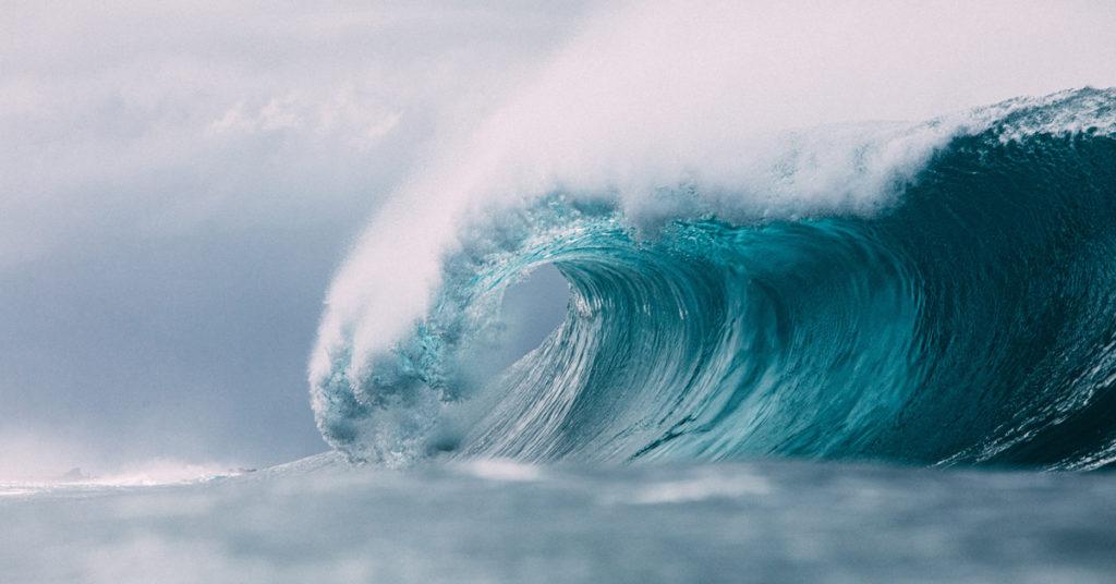
- Swell waves are characterized by the formation of long wavelength waves on the surface of the seas, propagating along the interface between water and air.
- They are commonly known as surface gravity waves due to their nature.
Origin:
- Unlike waves generated by immediate local winds, swell waves originate from distant weather systems.
- These waves are the result of prolonged wind action over a significant area of water, known as fetch.
- Even after the wind subsides or shifts, or the waves move away from the wind source, swell waves persist and continue to propagate.
Influencing Factors:
- The speed of the wind, the extent of ocean surface area affected by consistent wind direction (fetch), and the duration of time the winds persist over the same part of the ocean are all contributing factors to the formation and behavior of swell waves.
Characteristics of Swell Waves:
- Limited Frequency and Direction Range: Swell waves exhibit a narrower range of frequencies and directions compared to wind-generated waves occurring locally.
- Defined Shape and Direction: Swell waves assume a more distinct shape and direction, displaying less randomness than waves generated by local winds.
- Directional Orientation: Unlike wind waves, swell waves are characterized by the direction from which they originate rather than where they are headed.
- Wavelength Variation: Swell waves typically possess long wavelengths, although this can vary depending on the size of the water body.
- Generally, their wavelengths seldom exceed 150 meters.
- However, on occasion, particularly severe storms may produce swells with wavelengths surpassing 700 meters.
What are the Differences Between a Normal Wave and Swell Waves?
Normal Waves:
- Random Nature: Normal waves encompass any spontaneous disturbance occurring in the sea, exhibiting a wide array of forms, types, shapes, heights, periods, directions, and speeds.
- Varied Characteristics: Waves can manifest in diverse forms and attributes, subject to the prevailing conditions in the ocean.
Swell Waves:
- Deep-water Linear Waves: Swell waves are a distinct category of deep-water, linear waves originating or emerging from a chaotic wave system during external weather events due to wave dispersion.
- Defined Characteristics: Swells travel in a specific direction as uniform, high-speed, long waves that maintain consistency over time, with speeds determined by their wavelengths and periods.
- Extensive Travel: Swell waves traverse significantly greater distances compared to typical wave packets, exhibiting remarkable endurance.
- Independence from Local Weather: Swell waves remain unaffected by local weather systems, retaining their characteristics even in the presence of nearby weather phenomena.
INCOIS, ISRO to study rip currents for safer beaches
- 19 Feb 2024
Why is it in the News?
Indian National Centre for Ocean Information Services (INCOIS) and Indian Space Research Organisation (ISRO) have embarked on a project to continuously monitor and issue operational forecast alerts of rip currents.
What is a Rip Current?
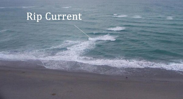
- Rip currents are channelled currents of water flowing away from shore at surf beaches.
- They typically extend from near the shoreline, through the surf zone and past the line of breaking waves. (The surf zone is the area between the high tide level on the beach to the seaward side of breaking waves.)
Formation of Rip Currents:
- Rip currents form when waves break near the shoreline, piling up water between the breaking waves and the beach.
- One of the ways this water returns to sea is to form a rip current, a narrow stream of water moving swiftly away from shore, often perpendicular to the shoreline.
Size of the Rip Currents:
- Rip currents can be as narrow as 10 or 20 feet in width though they may be up to ten times wider.
- The length of the rip current also varies.
- Rip currents begin to slow down as they move offshore, beyond the breaking waves, but sometimes extend for hundreds of feet beyond the surf zone.
Speed of the Rip Current:
- Rip current speeds can vary. Sometimes they are too slow to be considered dangerous.
- However, under certain wave, tide, and beach-shape conditions the speeds can quickly become dangerous.
Are All Rip Currents Dangerous?
- Rip currents are present on many beaches every day of the year, but they are usually too slow to be dangerous to beachgoers.
- However, under certain wave, tide, and beach-shape conditions they can increase to dangerous speeds.
- The strength and speed of a rip current will likely increase as wave height and wave period increase.
How Do Rip Currents Result in the Drowning of Swimmers?
- Drowning deaths occur when people pulled offshore are unable to keep themselves afloat and swim to shore.
- This may be due to any combination of fear, panic, exhaustion, or lack of swimming skills.
- Rip currents are the greatest surf zone hazard to all beachgoers. They can sweep even the strongest swimmer out to sea.
- Rip currents are particularly dangerous for weak and non-swimmers.
INCOIS wave rider buoy washes ashore in Gopalpur (New Indian Express)
- 04 Dec 2023
Why is it in the News?
A wave rider buoy, equipped belonging to the Indian National Centre for Ocean Information Services (INCOIS), with GPS and various weather-related instruments, was found ashore at the Gopalpur Military Station in Ganjam district on Saturday.
About Indian National Centre for Ocean Information Services (INCOIS):
- INCOIS is an autonomous organization under the Ministry of Earth Sciences (MoES).
- It is a unit of the Earth System Science Organization (ESSO), New Delhi.
- It is located in Hyderabad & was established in 1999.
- The ESSO operates as an executive arm of the Ministry of Earth Sciences (MoES) for its policies and programmes.
- It is mandated to provide the best possible ocean information and advisory services to society, industry, government agencies and the scientific community through sustained ocean observations and constant improvement through systematic and focused research.
What is the Earth System Science Organisation (ESSO)?
- Earth System Science Organisation (ESSO) is a virtual organisation set up by the Ministry of Earth Sciences GOI in 2007 and it is the executive arm of MoES.
- It has three major branches of earth sciences viz.,
- Ocean Science & Technology
- Atmospheric Science & Technology
- Geosciences and Technology.
- The overall vision of the ESSO is to excel in knowledge and technology enterprise for the earth system science realm towards the socio-economic benefit of the Indian sub-continent and in the Indian Ocean region.
- The ESSO contributes to the areas of Weather (General) and Weather advisories specific to agriculture, aviation, shipping, sports, etc. Monsoon, Disasters (cyclones, earthquakes, tsunamis, sea level rise), Living and non-living resources (fishery advisory, poly-metallic nodules, gas hydrates, freshwater etc), Coastal and Marine Ecosystems and Climate Change, Underwater Technology.