Bathymetry
- 26 Apr 2024
Why is it in the News?
Scientists from the Indian National Centre for Ocean Information Services (INCOIS) recently conducted a study of the bathymetry, or ocean floor, in the Indian Ocean.
What is Bathymetry?
- Bathymetry is a technique dedicated to mapping the depths of water bodies, that is, it is the measurement and representation of the topography of the bottom of rivers, seas, and oceans.
- In addition to measuring depth, this study also includes identifying underwater relief and creating three-dimensional maps of the sea floor.
- The word “bathymetry” comes from the Greek "bathýs", meaning deep, and "metron", meaning measure.
- Bathymetry allows for obtaining information about the physical characteristics of the sea floor, such as seamounts, mountain ranges, valleys, abyssal plains, and underwater canyons.
How is Bathymetry Performed?
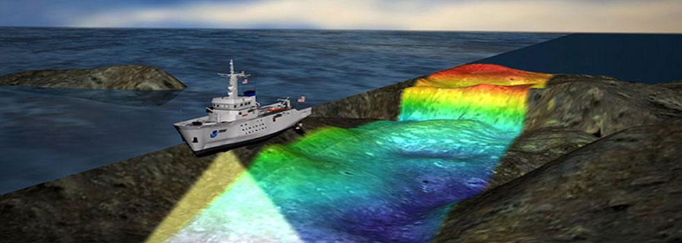
- To carry out bathymetry, specific equipment is used, such as multibeam sonar (MultiBeam Echosounder), IMU (Inertial Measurement Unit), and high-precision positioning systems (via satellite with RTK correction).
- Multibeam sonar emits sound pulses toward the sea floor and measures the time it takes for the sound to return to the sensor after being reflected by submerged surfaces.
- Based on this sound return time and knowledge of the exact position of the vessel and its attitude (roll, pitch, yaw), it is possible to calculate the depth at a given point.
- The bathymetry service generates charts, blueprints, and digital models (2D and 3D) of the sea floor.
- LiDAR sensors, on the other hand, are used to detect data through beams of light above the waterline, mapping slopes, rockfills, and channel walls.
- The fusion of bathymetry data with Lidar data allows the three-dimensional construction of the environment in very high resolution.
- Allowing the client to plan or verify works and/or assets in the region of interest.
About Indian National Centre for Ocean Information Services (INCOIS):
- Established in 1999, the Indian National Centre for Ocean Information Services (INCOIS) under the Ministry of Earth Science, Govt of India.
- It is mandated to provide ocean information and advisory services to a broad spectrum of users through sustained ocean observations and constant improvements through systematic and focused research.
- The activities include data services, consultancy, and capacity development.
- HQ: Hyderabad
- INCOIS is a permanent member of the Indian delegation to the IOC of UNESCO and a founding member of the Indian Ocean Global Ocean Observing System (IOGOOS) and the Partnership for Observing the Oceans (POGO).