IIT Guwahati researchers devise mathematical model to help prevent riverbank erosion (Indian Express)
- 23 Dec 2023
Why is it in the News?
A team of researchers at the Indian Institute of Technology (IIT) Guwahati has developed a new award-winning mathematical model to help prevent erosion of rivers like Brahmaputra.
What is BRAHMA-2D?
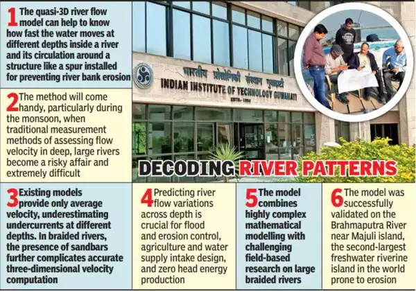
- BRAHMA-2D (Braided River Aid: Hydro-Morphological Analyzer) is a sophisticated mathematical model designed for assessing the flow dynamics of expansive braided rivers such as the Brahmaputra.
- Functioning as a quasi-3D river flow model, BRAHMA-2D offers insights into water velocity at various depths within the river and the circulation patterns around structures like spurs, crucial for preventing river bank erosion.
- Developed through collaboration between researchers at IIT Guwahati and the Brahmaputra Board under the Union Ministry of Jal Shakti, this innovative model plays a pivotal role in the design of sustainable hydraulic structures.
- Engineers can leverage BRAHMA-2D to create effective structures like spurs, river bends, and other protective measures to combat river bank erosion.
- The model's successful validation on the Brahmaputra River near Majuli Island in Assam, a region prone to river bank erosion, underscores its practical applicability.
- BRAHMA-2D integrates a two-dimensional water movement model with entropy theory, focusing on disorder or randomness.
- Notably, it identifies a unique dip phenomenon near spurs, where water flows underneath intensifies—a phenomenon absent at points away from these structures.
- Beyond erosion prevention, BRAHMA-2D extends its utility to environmental studies by assessing the habitat suitability of aquatic species, particularly endangered ones.
- This assessment is based on factors such as required depth and flow velocity, showcasing the model's versatility in addressing multifaceted challenges in river ecosystems.
About Brahmaputra River:
- Originating as Siang or Dihang from the Chemayungdung glacier in the Kailash range near Mansarovar Lake, the Brahmaputra enters India to the west of Sadiya town in Arunachal Pradesh.
- Tributaries: Dibang, Lohit, Siang, Burhi Dihing, Tista, and Dhansari contribute to its flow.
- This perennial river exhibits distinctive features influenced by its geography and prevailing climatic conditions.
- Experiencing biannual flooding, the first occurs from the melting Himalayan snow in summer, and the second is a consequence of monsoon flows.
- Climate change has amplified the frequency and intensity of these floods, posing a threat to populations and food security in the lower riparian states of India and Bangladesh.
- Known for its dynamism, the Brahmaputra undergoes frequent changes in course, driven by landslides and geological activities.