Antarctic Treaty Consultative Meeting (ATCM)

- 09 May 2024
Why is it in the News?
India is working with like-minded countries to promote regulated tourism in Antarctica as a steady increase in the number of tourists threatens to harm the fragile ecology in the White Continent.
About the Antarctic Treaty Consultative Meeting:
- The Antarctic Treaty Consultative Meeting (ATCM) is the annual meeting of the Parties to the 1959 Antarctic Treaty.
- The meeting serves as a platform for the exchange of information, discussion of common interests, and promotion of the principles and purposes of the Antarctic Treaty.
- The first ATCM was held in 1961, and initially occurred every other year, though the frequency has since increased.
- During the ATCM, representatives of the member countries address various issues related to Antarctica, such as environmental protection, scientific research, and tourism regulation.
- Key agenda items include strategic planning for sustainable management of Antarctica and its resources, policy, legal, and institutional operations, and biodiversity prospecting.
- The ATCM is organized by the Antarctic Treaty Secretariat, which is headquartered in Buenos Aires, Argentina, and was established in 2004.
- The Secretariat is responsible for facilitating communication and information exchange among the parties involved in the Antarctic Treaty System.
- In recent years, the ATCM has been hosted by various countries, with India hosting the 46th meeting in 2024.
- The Ministry of Earth Sciences (MoES), Government of India, through the National Centre for Polar and Ocean Research (NCPOR) and the Secretariat of the Antarctic Treaty will jointly organise the 46th Antarctic Treaty Consultative Meeting (ATCM 46) from 20 to 30 May 2024 at the Lulu Bolgatty International Convention Centre (LBICC) in Kochi, India.
What is the Antarctic Treaty?
- The Antarctic Treaty is an international agreement that aims to preserve and protect the Antarctic continent and its surrounding waters for scientific research and peaceful purposes.
- Signed on December 1, 1959, by 12 countries, the treaty came into effect on June 23, 1961.
- The treaty establishes Antarctica as a natural reserve devoted to scientific research, and it designates the area south of 60°S latitude as a region free of military and nuclear activities.
Key aspects of the treaty include:
-
- Freedom of scientific research and exploration, with cooperation among signatory nations
- Exchange of scientific information and personnel between treaty member nations
- Prohibition of military activities, such as the establishment of military bases or weapons testing
- Prohibition of nuclear explosions and disposal of radioactive waste
- Acknowledgement that no new territorial claims can be made on the continent
- Designation of Antarctica as a "Special Conservation Area" to protect its ecosystems and native species
- Currently, 54 countries have ratified the Antarctic Treaty, and 29 of these countries have Consultative Party status.
- Consultative Parties have the right to participate in decision-making processes related to the management and governance of the Antarctic region, while Non-Consultative Parties are encouraged to engage in scientific research and exchange information.
- On 12 September 1983, India became the fifteenth Consultative Member of the Antarctic Treaty.
- It participates in the decision-making process along with the other 28 Consultative Parties to the Antarctic Treaty.
- India’s first Antarctic research station, Dakshin Gangotri, was established in 1983.
- At present, India operates two year-round research stations: Maitri (1989) and Bharati (2012).
- The permanent research stations facilitate Indian Scientific Expeditions to Antarctica, which have been ongoing annually since 1981.
- In 2022, India enacted the Antarctic Act, reaffirming its commitment to the Antarctic Treaty.
Ross Ice Shelf

- 25 Apr 2024
Why is it in the News?
New research has found a "missing piece of the puzzle" of West Antarctic Ice Sheet melt, revealing that the collapse of the ice sheet in the Ross Sea region can be prevented—if we keep to a low-emissions pathway.
About Ross Ice Shelf:
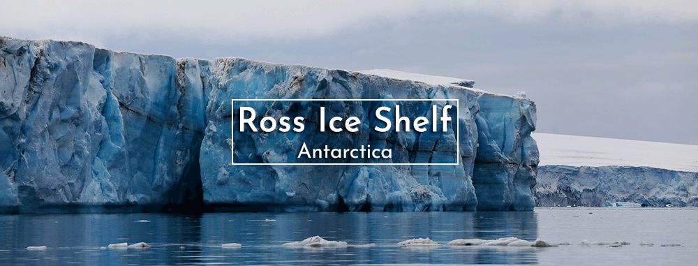
- The Ross Ice Shelf is a floating mass of land-ice, with a front between 15 and 50 meters high. ?
- It is the largest ice shelf in Antarctica.
- Situated in the Ross Sea, it extends off the coast into the ocean, covering an impressive 487,000 square kilometers, roughly the size of France.
- Despite its vast surface area, only 10% of the ice shelf is visible above the water, mostly concealed beneath hundreds of meters of ice.
- The thickness of the Ross Ice Shelf varies significantly, ranging from about 100 meters to several hundred meters at its thickest points near the areas where the shelf connects to the Antarctic continent.
- The formation of the Ross Ice Shelf is the result of snow accumulation and compaction over time, which ultimately transforms into ice.
- It is continuously fed by glaciers draining from both the East and West Antarctic Ice Sheets, creating a balance as new ice is added while existing ice is removed through melting at the base and calving at the front.
- This massive ice shelf plays a critical role in stabilizing the Antarctic ice sheet.
About the Ross Sea:
- Location and Size: The Ross Sea is a vast, remote bay located just 320 km from the South Pole, positioned south and slightly east of New Zealand.
- It covers an area of approximately 370,000 square miles (960,000 square km), making it the largest polar marine ecosystem in the world.
- The sea's dynamics are significantly shaped by the coastal East-Wind Drift, which establishes a vast clockwise gyre, complemented by deepwater upwelling phenomena.
- Notably, it holds the distinction of being Antarctica's first protected area, serving as a habitat for a plethora of penguin species and numerous whale species.
- Depth: Despite its vast size, the Ross Sea is relatively shallow, with an average depth of approximately 530 meters.
- Historical Exploration: The sea is named after British explorer Sir James Clark Ross, who first visited the area in 1841 during his expedition to Antarctica.
- The Ross Sea's importance to both the scientific community and global conservation efforts cannot be overstated, as it provides valuable insights into the effects of climate change on polar ecosystems.
NASA Recently Shared a Satellite Image of Deception Island (Tribune India)

- 11 Oct 2023
Why in the News?
National Aeronautics and Space Administration (NASA) recently shared a satellite image of Deception Island, one of the only places in the world where a ship can sail directly into the centre of an active volcano.
About Deception Island:
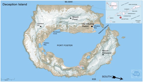
- Deception Island is situated within the South Shetland Islands, forming part of an archipelago northwest of the Antarctic Peninsula.
- This volcanic island is notable for its dynamic features and distinct geography.
- Originating from a colossal volcanic eruption, Deception Island's formation resulted in the collapse of its central structure, allowing seawater to inundate the resulting caldera.
- The landscape is characterized by desolate volcanic slopes, steaming beaches, and glaciers adorned with ash layers, creating a unique horseshoe-shaped entrance to the sea via Neptune’s Bellows.
- The island encircles Port Foster, recognized as one of the safest harbours in the Antarctic, offering vessels a rare opportunity to navigate into the heart of an active volcano.
- Among the few places globally where this is possible, Deception Island has experienced over twenty eruptions since the 19th century.
- Notably, the island witnessed three volcanic eruptions from 1967 to 1970, leading to the destruction of Chilean and British stations.
- Presently, Argentina and Spain maintain summer scientific stations on the island.
- Deception Island is safeguarded under the Antarctic Treaty, designating it as a protected area with restricted human visits and minimized environmental impact.
