Cyclone Michaung to make landfall in Tamil Nadu: What is a cyclone — and its different types? (Indian Express)
- 02 Dec 2023
Why is it in the News?
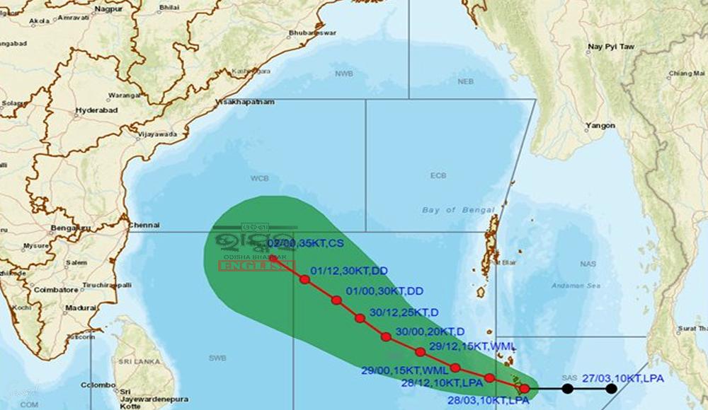
Cyclone Michaung: The deep depression currently over the Bay of Bengal is likely to intensify into a cyclonic storm within the next 24 hours, bringing heavy rain to coastal Tamil Nadu and Andhra Pradesh.
News Summary:
- The India Meteorological Department (IMD) has issued a warning as Cyclone Michaung looms over the Bay of Bengal and the South Andaman Sea.
- It is the fourth tropical cyclone of the year over the Bay of Bengal.
- With the potential to intensify, the cyclone is expected to make landfall in and around Tamil Nadu on December 4, prompting concerns and precautionary measures across southern India.
- Govt. has issued an ‘orange’ alert over Tamil Nadu, as well as coastal and interior Andhra Pradesh, and issued advisories to fishermen in coastal areas, urging them to suspend activities in the sea for safety reasons.
What is a Cyclone?
- A cyclone is a large-scale system of air that rotates around the centre of a low-pressure area. It is usually accompanied by violent storms and bad weather.
- As per NDMA, a cyclone is characterised by inward spiraling winds that rotate anticlockwise in the Northern Hemisphere and clockwise in the Southern Hemisphere.
- The National Disaster Management Authority (NDMA) classifies cyclones broadly into two categories: tropical cyclones and extratropical cyclones.
What are Tropical Cyclones?
- Tropical cyclones is a weather phenomenon formed only over warm ocean waters near the equator.
Formation:
- When warm, moist air over the ocean rises upward from near the surface, a cyclone is formed.
- When the air rises up and away from the ocean surface, it creates an area of lower air pressure below.
- It causes the air from surrounding areas with higher pressure to move towards the low-pressure area which further leads to the warming up of the air and causes it to rise above.
- As the warm, moist air rises and cools the water in the air forms clouds.
- The complete system of clouds and wind spins and grows, along with the ocean's heat and water evaporating from the ocean surface.
- As the wind system rotates with increasing speed, an eye gets formed in the middle.
- The centre of a cyclone is very calm and clear with very low air pressure.
- The difference in temperature between the warm, rising, and cooler environment causes the air to rise and become buoyant.
- When the wind speed is 39 mph (63 kmph), the storm is called a "tropical storm".
- Whereas when the wind speed reaches 74 mph (119 kmph), the storm is officially a "tropical cyclone" or hurricane.
- Annually, around 70 to 90 cyclonic systems develop all over the globe.
- The Coriolis force causes the wind to spiral around a low-pressure area.
- As the presence of Coriolis force is negligible in the equatorial belt between 5 degrees north and 5 degrees south latitudes, hence cyclonic systems do not develop in this region.
What are Extratropical Cyclones?
- Extratropical cyclones are also known as mid-latitude depressions, temperate cyclones, frontal depressions, and wave cyclones.
- They occur in the mid-latitudinal region, between 35° and 65° latitude, in both hemispheres.
- These cyclones move from west to east, especially during the winter seasons, when polar and tropical air masses meet and create fronts.
Formation of Extratropical Cyclones:
- Temperate cyclones form following the Polar Front theory.
- This theory explains that warm-humid air from the tropics meets cold-dry air from the poles, forming a polar front.
- The denser and heavier cold air pushes up the warm air, creating instability and low pressure at their meeting point.
- This low pressure results in a void that surrounding air rushes in to fill.
- Due to the Earth's rotation, a cyclone is formed at the center of these interactions.
- Extratropical cyclones are less intense compared to the more severe cyclones or hurricanes in tropical regions, which develop in areas with more consistent temperatures.
How are Tropical Cyclones Named?
- The meteorologist gives each tropical cyclone a name to avoid confusion, according to the World Meteorological Organisation.
- In general, tropical cyclones are named according to the rules at the regional level.
- For the Indian Ocean region, a formula for naming cyclones was agreed upon in 2000.
- Thirteen countries in the region - Bangladesh, India, Iran, Maldives, Myanmar, Oman, Pakistan, Qatar, Saudi Arabia, Sri Lanka, Thailand, United Arab Emirates, and Yemen - contributed a set of names, which are assigned sequentially whenever a cyclonic storm develops.
- Worldwide, there are six regional specialised meteorological centres (RSMCs) and five regional Tropical Cyclone Warning Centres (TCWCs) mandated for issuing advisories and naming tropical cyclones.
- The names are chosen to be easy to remember and pronounce, and they must not be offensive or controversial.
- They are also chosen from a variety of languages so that people from different regions can identify with them.
- Cyclone Michaung, for example, is one of the names proposed by Myanmar, which means "strength and resilience".
- The responsibility of choosing a name for a cyclone in the North Indian Ocean falls upon the Indian Meteorological Department, in accordance with the decree issued by the World Meteorological Organisation (WMO).
- The naming system has evolved over time. In the early years of the practice, the names were chosen alphabetically, with one name assigned to each letter of the alphabet.
- However, this system was found to be confusing and difficult to remember, so the current system of pre-defined names was introduced.
- In the Atlantic and Southern hemispheres (Indian Ocean and South Pacific), tropical cyclones receive names in alphabetical order, alternating between women’s and men's names.
- In the Northern Indian Ocean, nations began using a new system for naming tropical cyclones in 2000.
- Names are listed alphabetically country-wise and are neutral gender-wise.
- The name list is proposed by the National Meteorological and Hydrological Services of WMO Members of a specific region and approved by respective tropical cyclone regional bodies at their annual or biennial sessions.
How are Cyclones Classified?
- Cyclones are categorized on the basis of the strength of the winds by the Indian Meteorological Department (IMD):
- Depression: Wind speeds of between 31–49 km/h
- Deep Depression: Between 50-61 km/h
- Cyclonic Storm: Between 62–88 km/h
- Severe Cyclonic Storm: Between 89-117 Km/h
- Very Severe Cyclonic Storm: Between 118-166 Km/h
- Extremely Severe Cyclonic Storm: Between 166-221 Km/h
- Super Cyclonic Storm: Above 222 Km/h
Indian Meteorological Department (IMD):
- Established in 1875, the India Meteorological Department (IMD) serves as the National Meteorological Service of the country and is the primary government agency for meteorology and related subjects.
- The Director General of Meteorology leads the department, overseeing its operations.
Key Features:
- The IMD operates under the Ministry of Earth Sciences (MoES) and has its headquarters in New Delhi.
- There are six Regional Meteorological Centres, each headed by a Deputy Director General, located in Mumbai, Chennai, New Delhi, Calcutta, Nagpur, and Guwahati.
IMD's Mandate:
- Conduct meteorological observations and provide current and forecast meteorological information for activities such as agriculture, shipping, aviation, and offshore oil explorations.
- Issue warnings for severe weather phenomena, including tropical cyclones, norwesters, duststorms, heavy rains and snow, and cold and heat waves.
- Supply meteorological statistics essential for agriculture, water resource management, industries, oil exploration, and other nation-building activities.
- Conduct and promote research in meteorology and related disciplines.